![]()
United
Nations
Inundación
, processed by ESA, CC BY-SA 3.0 IGO.")
Definition
Facts and figures
Further information
UN-SPIDER Regional Support Offices with hazard-specific expertise
Related content on the Knowledge Portal
As the arrival of spring increases the risk of severe weather, NOAA's geostationary and polar-orbiting satellites, such as GOES East, GOES West, Suomi NPP, and NOAA-20, are closely monitoring the changing weather patterns.
GOES-16 and GOES-18 satellites provide real-time information about cloud properties, such as overshooting tops, gravity waves, and above-anvil cirrus plumes, as well as the temperature of cloud tops. This data helps forecasters track weather conditions, identify the severity of a storm, determine wind speeds, and predict the movement of the storm. In addition, these satellites use the Geostationary Lightning Mapper (GLM) instrument to monitor lightning activity, detecting total lightning activity and providing information about the extent and distance of lightning flashes. Scientists are also using AI to train the ProbSevere LightningCast model, which can predict lightning up to an hour before the first observation of lightning flashes, helping...
read more17/03/2023
Southern and Central provinces in Zambia are underwater after long-term rainfall starting 11 January, causing overflowing rivers. The floods, reported as “catastrophic” by Zambia’s Disaster Management and Mitigation Unit, have caused widespread damage to homes, farmland, and livestock. The floods have also left numerous communities isolated and sanitation facilities completely submerged, exposing the population to a high risk of waterborne diseases.
The International Water Management Institute (IWMI) has offered its support in developing a post-flood recovery strategy and strengthening digital climate agro-advisory services in Zambia.
Spokespersons at IWMI expressed the importance of enhancing emergency preparedness and response capacities to mitigate the impact of climate shocks. Furthermore, IWMI’s representatives also...
read moreRegional Support Offices mentioned:01/03/2023
The United Nations Platform for Space-based Information for Disaster Management and Emergency Response (UN-SPIDER) in collaboration with the German Aerospace Centre (DLR), the Global Flood Awareness System (GLOFAS) of the Copernicus Programme of the European Commission, and the University of Bonn’s Centre for Remote Sensing of Land Surfaces (ZFL), conducted an international training workshop on space-based technologies for flood management. The workshop was held at the UN Bonn Campus on 20-22 February 2023.
The workshop had an impressive turnout of nearly 30 attendees, including representatives from national disaster management agencies, space agencies, government agencies, and students enrolled in universities from various countries including Algeria, Barbados, Germany, Ghana, Italy, Kenya, Mexico, Mozambique, Nigeria, Pakistan, South Africa, Spain, Sri Lanka, Turkey, Uganda, and the United Kingdom.
The event aimed to increase the awareness of and developing skills...
read more28/02/2023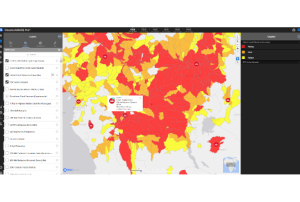
This is an excerpt from an article by NASA Earth Science, Applied Sciences.
Floods are among the most deadly and destructive disasters worldwide, and climate change has only increased their severity. To make matters worse, many smaller communities lack the tools they need to detect and respond to floods, leaving them vulnerable to the full force of their impacts.
To help protect these communities, NASA's Earth Applied Sciences Disasters program area has partnered with several leading scientific institutions to develop a new flood detection tool called "Model of Models" (MoM). This tool combines data from open-source hydrological models with Earth observing satellite data to generate global flood risk severity updates several times a day. This is the first time that comprehensive global flood early warnings have...
read more05/01/2023
The Center for Remote Sensing of Land Surfaces (ZFL) of the University of Bonn in Germany (German Regional Support Office of UN-SPIDER) is organizing an online training on 16 December 2022. It aims to provide an overview of Copernicus tools and data in the context of floods and droughts. With the help of the tools and platforms presented during this training, participants will be able to make use of earth observation data in the context of floods and droughts without the need of extensive background knowledge. There will be a focus on African examples throughout the training. The training is specifically meant for participants from African countries from government agencies, academia, NGOs or other institutions involved in disaster management or risk reduction.
Find more information and the registration link...
read moreRegional Support Offices mentioned:09/12/2022
New WMO Guidelines on the Implementation of a Coastal Inundation Forecasting Early Warning System offer solid and practical advice for countries, donors and experts seeking to set up early warning systems against an increasing hazard.
The guidelines are a contribution to the UN Early Warnings for All initiative and reflect the high priority needs of small island developing States (SIDS) and Least Developed Countries that are particularly vulnerable to these coastal hazards.
“The severity of the impacts of disasters, especially on coastal communities, is well known and documented. A contributing factor is the increasing intensity and frequency of meteorological and oceanographical hazards caused by climate change, including sea-level rise, which can seriously affect SIDS and other coastal nations,” state the...
read more28/10/2022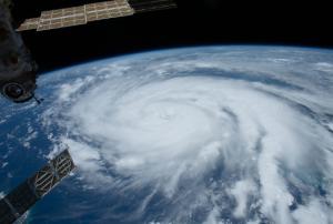
This article is republished from The Conversation under a Creative Commons license. Read the original article.
Authors: Zhe Zhu, University of Connecticut and Su Ye, University of Connecticut
Hurricane Ian left an extraordinarily broad path of destruction across much of South Florida. That was evident in reports from the ground, but it also shows up in satellite data. Using...
read more10/10/2022
The National Space Research and Development Agency (NASRDA), UN-SPIDER and the Centre for Remote Sensing of Land Surfaces (ZFL) of the University of Bonn organized a 3-day interinstitutional workshop to improve disaster preparedness in case of very large floods in Nigeria. The workshop, held in Abuja from 12 to 14 September 2022, addressed the use of space-based information provided by emergency mechanisms such as the International Charter Space and Major Disasters and services by the Copernicus programme such as the Global Flood Awareness System (GLOFAS) to take note of potential floods.
The Organizing Committee also included the National Emergency Management Agency of Nigeria (NEMA), the Nigeria Hydrological Services Agency (NIHSA), the Nigerian Meteorological Agency (NiMet) and the National Disaster Management Organization of Ghana (NADMO). The workshop brought together more than one hundred participants from several government agencies, UN agencies and other...
read more15/09/2022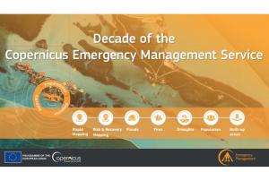
Implementing science to save lives: A Decade of the Copernicus Emergency Management Service
The Copernicus Emergency Management Service (CEMS) celebrates a decade of operation as a world leader in emergency mapping, early warning tools and open-access disaster information.
For the past ten years, CEMS has provided a global service as a fully operation emergency mapping service at no cost to users and with open access data.
Some highlights on the contribution of CEMS in global disaster risk management activities:
- 576 Rapid Mapping Activations with 5,500+ maps delivered
- Designed and implemented the world’s first Global Flood Monitoring tool
- Ten years of wildfire forecasts up to ten days into the future
- Average of 200+ flood and 500+ flash flood notifications to Member States and authorised users each year
- Offers a current and historical database of 7,000+ drought episodes since 1950
...
read more22/06/2022
On 10 May 2022, the United Nations Office for Outer Space Affairs (UNOOSA), the University of Energy and Natural Resources of Ghana, and the Prince Sultan Bin Abdulaziz International Prize for Water (PSIPW) inaugurated the 5th International Conference on the Use of Space Technology for Water Resources Management. The conference, held in Accra from 10 to 13 May 2022, aims to promote the use of space technology in water management in developing countries.
During the opening segment of the conference, high ranking authorities noted that there have been many success stories related to the Sustainable Development Goals (SDGs), but unfortunately some of these were eroded by the COVID 19 pandemic. They remarked that Ghana is hosting this conference to see how best to foster new partnerships to address the SDGs, and to facilitate a constructive discussion on two key issues essential to sustainable development: Space technologies and sustainable use of water...
read more12/06/2022
UN-SPIDER Regional Support Offices with hazard-specific expertise
![]()