  • English
  • Español
  • Français

United
Nations


Office for Outer Space Affairs
UN-SPIDER Knowledge Portal

  • Inicio
  • Sobre nosotros
    • Sobre ONU-SPIDER
    • Acerca de UNOOSA
    • Publicaciones
    • Ofertas de trabajo
    • Conozca el Equipo
    • Contacto
  • Aplicación Espacial
    • Guías Tecnológicas
    • Mecanismos de Emergencia
    • Mecanismos de Recuperación
    • Red Internacional de Alerta de Asteroides
    • Grupo Asesor para la Planificación de Misiones Espaciales
    • Iniciativa Internacional sobre Meteorología Espacial
    • Tecnologías Espaciales en la ONU
    • Historias de Usuarios
  • Enlaces y Recursos
    • Aplicación de datos del mes
      • Disaster Recovery
    • Fuentes de Datos
    • SIG y Software de Percepción Remota
    • Recursos de capacitación en línea
    • Instituciones
  • Riesgos y Desastres
    • Gestión del Riesgo de Desastres
    • Alerta temprana
    • Gestión de Desastres y Emergencias
    • Amenazas Naturales
    • El Proceso de la Reducción de Desastres Post-2015
    • La ONU y la Gestión del Riesgo de Desastres
    • La ONU y Alerta Temprana
    • La ONU y la Gestión de Desastres
  • Asesoría
    • Misiones de Asesoría
    • Apoyo en caso de Emergencia
    • Asesoría Virtual
    • Prácticas Recomendadas
    • Actividades de Entrenamiento
    • Usos Prácticos
  • Redes
    • Oficinas Regionales de Apoyo
    • GP-STAR
    • IN-MHEWS
    • IWG-SEM
  • Proyectos
    • SPEAR
    • FOSAT-S
    • EvIDENz
    • Flood GUIDE
  • Noticias y Eventos
    • Noticias
    • Eventos
    • Eventos pasados

Breadcrumb

  • Home
  • Taxonomy Pages
  • Taxonomy Pages

Syrian Arab Republic

country taxonomy block

Satellite Data Aids Emergency Response and Recovery Efforts Following Earthquakes in Turkey and Syria
Deformation map over Türkiye and Syria

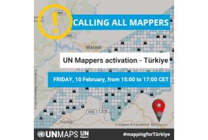
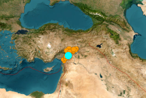
Turkey and Syria recently experienced two devastating earthquakes of magnitude 7.8 and closely followed by a magnitude 7.5, resulting in extensive damage and destruction. The International Charter 'Space and Major Disasters' was activated by Turkish authorities, the United Nations, and the International Federation Red Cross & Red Crescent Societies in response to the earthquakes. The Charter provided more than 350 crisis images from 17 space agencies worldwide, which were used to create damage and situation maps to estimate the hazard impact and support relief actions. The Copernicus Emergency Mapping Service (CEMS), which has a cooperation agreement for sharing data and collaborating with the Charter, has also been activated. The service, which has a collaboration agreement for data sharing and working with the Charter, also employs observations from several satellites to deliver on-demand mapping.

Satellite data is proving to be invaluable for emergency aid...

more
Publishing date 16/02/2023
UN Mappers Activation - Mapathon to support Turkey
UN Mappers Activation - Turkey

UN Mappers calls all mappers to support the Turkish Open Street Map community following the earthquake that hit southern Turkey and northern Syria on Monday 6 February.

Together with Copernicus and the International Charter activation, UN Mappers has also been activated. The community has organised a "mapathon", that will be held live on Friday 10 February from 15:00 to 17:00 CET, although mappers are invited to continue the activity over the weekend.

Click here for more information on the event. Registration is already open!

Publishing date 09/02/2023
Earthquake in Turkey and Syria - International Charter and Copernicus active
Earthquake Turkey 2023

A major earthquake of magnitude 7.8 struck Turkey with epicentre on 23 kilometres east of Nurdagi (Gaziantep Province) on February 6, 2023. By the activity spreading to adjacent faults, the region was hit by a 6.7- magnitude and a 7.5- magnitude aftershocks respectively. The earthquake also affected neighbouring Syria.

The space community is also taking action through the activation of the International Charter on Space and Major Disasters. The charter provides a mechanism for the provision of satellite data to support the relief efforts of disaster-stricken areas. The Copernicus Emergency Management Service (EMS) has also been activated to provide support to the affected countries.

The use of space-based information can greatly assist in disaster response efforts. Satellites can provide detailed images and maps of the affected area to help search and rescue teams identify areas in need of assistance. They can also provide information on the extent of the damage,...

more
Publishing date 07/02/2023
Syria: Crowdsourcing Satellite Imagery Analysis to Identify Mass Human Rights Violations

What if we crowdsourced satellite imagery analysis of key cities in Syria to identify evidence of mass human rights violations? This is precisely the question that my colleagues at Amnesty International USA’s Science for Human Rights Program asked me following this pilot project I coordinated for Somalia. AI-USA has done similar work in the past with their Eyes on Darfur project, which I blogged about here in 2008. But using micro-tasking with backend triangulation to crowdsource the analysis of high resolution satellite imagery for human rights purposes is definitely breaking new ground.

A staggering amount of new satellite imagery is produced every day; millions of square kilometers’ worth according to one knowledgeable colleague. This is a big data problem that needs mass human intervention until the software can catch up. I recently spoke with Professor Ryan Engstrom, the Director of the Spatial Analysis Lab at George Washington University, and he confirmed...

more
Publishing date 12/09/2011
Syrian Arab Republic

General Organization for Remote Sensing (GORS)

Contact

General Organization for Remote Sensing (GORS)


Tel. + 963 11 2218700


Email: gors@mail.sy


Address:


P.O. Box 12586


Damascus,


Syrian Arab Republic

Footer menu

  • Contact
  • Terms of Use

User account menu

  • Log in