Latin America and Caribbean

country taxonomy block

Como otras regiones del mundo, América Latina está expuesta a múltiples tipos de amenazas o peligros de tipo geológico e hidrometeorológico que desencadenan desastres.  Para contribuir al fortalecimiento de capacidades de profesionales que colaboran en la generación de información geoespacial útil para la respuesta en caso de desastres; ONU-SPIDER, la Comisión Económica para América Latina y el Caribe, CEPAL, y la Carta Internacional Espacio y Grandes Desastres organizaron el Curso de Entrenamiento “Gerencia de proyectos de la Carta Internacional Espacio y Grandes Desastres usando el Charter Mapper”.  Este curso se implementó en la sede de la CEPAL, en Santiago de Chile, del 7 al 9 de noviembre, y fue dirigido a a 15 profesionales de Argentina, Bolivia, Brasil, Chile, Colombia, Costa Rica, Ecuador, México, Paraguay y Perú, que ya tienen experiencia en las…

more
Publishing date 07/11/2023

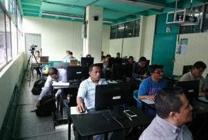
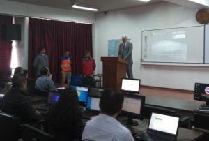
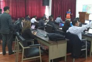
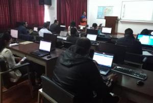
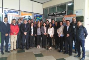
As in the case of other regions of the world, Latin America is exposed to various types of geological and hydro-meteorological hazards which trigger disasters.  To contribute to strengthen the skills of professionals that contribute to disaster response efforts through the generation of space-based information, UN-SPIDER, ECLAC and the International Charter Space and Major Disasters organised the training course "Project Management using the ESA Charter Mapper".   The training course brought together 15 professionals with skills in project management in case of activations of the International Charter from Argentina, Bolivia, Brazil, Chile, Colombia, Costa Rica, Ecuador, Mexico, Paraguay and Peru. The training course was held in the premises of ECLAC in Santiago de Chile from 7 to 9 November 2023 and its aims have been:

  • To introduce participants to the novel "ESA Charter Mapper" tool implemented by the International Charter.
  • To…
more
Publishing date 07/11/2023

The VIII Regional Platform for Disaster Risk Reduction in the Americas and the Caribbean (RP23) has successfully concluded in Punta del Este, Uruguay. The event was held in a hybrid format from February 28 to March 2, 2023, under the theme, “Science and Technology for Integrated Disaster Risk Management”. The Government of Uruguay hosted the forum, which aimed to bring together a wide range of stakeholders to discuss and address the issue of disaster risk reduction.

The forum was organized as an inclusive event, and participants had the option to attend either in person or online. The multi-stakeholder approach of the Regional Platform brought together Member States, Parliamentarians, Local Governments, United Nations system entities, Intergovernmental Organizations, private sector, media, major groups, and other stakeholder groups.

The event highlighted the importance of science and technology in integrated disaster risk management. Participants discussed various…

more
Publishing date 03/03/2023

Los incendios forestales representan una amenaza para muchos países alrededor del mundo, incluyendo México.  Desde 1999, la Comisión Nacional para el Conocimiento y Uso de la Biodiversidad (CONABIO) empezó a utilizar las tecnologías de información y comunicación para desplegar información sobre incendios forestales de manera más sistemática. Además, inició esfuerzos para establecer un Sistema de Alerta Temprana para tales Incendios Forestales (SATIF).  La meta de SATIF es generar y proporcionar geoinformación derivada de datos satelitales para el monitoreo y alerta temprana de incendios forestales, que contribuya a conservar la biodiversidad y salvaguardar la vida humana.   SATIF está estructurado en base a tres sistemas:

more
Publishing date 14/01/2022

ONU-SPIDER, la Carta Internacional Espacio y Grandes Desastres, el Centro de Coordinación para la Prevención de Desastres Naturales en América Central y República Dominicana (CEPREDENAC) y la Universidad Federal de Santa María de Brasil (UFSM) organizaron un curso de entrenamiento para facilitar la activación de la Carta Internacional Espacio y Grandes Desastres en México, América Central y República Dominicana, Dicho curso se llevó a cabo en Ciudad Guatemala del 30 de noviembre al 2 de diciembre del 2021.  El curso fue brindado por expertos de la Comisión Nacional de Actividades Espaciales de Argentina (CONAE), el Instituto Nacional de Investigaciones Espaciales de Brasil (INPE), el Servicio Geológico de los Estados Unidos (USGS) y UFSM. Los expertos  describireron el proceso que utiliza la Carta Internacional en caso de activaciones y los procedimientos y lineamientos que deben seguir los gerentes de proyecto que son designados por la Carta Internacional en caso de…

more
Publishing date 11/12/2021
Regional Support Offices mentioned:

To facilitate the activation of the International Charter Space and Major Disasters in Central America, Mexico and Dominican Republic, UN-SPIDER, the Central American Coordination Centre for Natural Disaster Prevention (CEPREDENAC) and the International Charter Space and Major Disasters organized a regional training course in Guatemala City, Guatemala, from 30 November to 02 December 2021.   Experts from the National Commission on Space Activities of Argentina (CONAE), National Space Research Institute of Brazil (INPE), and the United States Geological Survey (USGS) made participants aware of the procedures used by the International Charter in case of activations, and on the procedures and guidelines that project managers designated by the International Charter must follow when designated as project managers in case of activations. In addition, an expert from the Federal University of Santa Maria of Brazil (UFSM), in its role as a UN-SPIDER Regional Support Office,…

more
Publishing date 11/12/2021
Regional Support Offices mentioned:

Increasing in frequency and severity, wildfires have had a devastating impact in several areas around the world in recent years. The effects of wildfires pose a particular risk to the environment and communities in the Latin America and Caribbean (LAC) region. In order to mitigate the effects of wildfires and support wildfire risk management in the region, the Joint Research Centre (JRC) of the European Commission (EC) recently launched country profiles under the Global Wildfire Information System (GWIS).

A wildfire refers to “an unplanned, unwanted wild land fire”. Wildfires are both caused by man-made activity (slash/burn land clearing) and natural events (lightning or extreme drought). The likelihood of a wildfire increases dramatically in the dry season and during…

more
Publishing date 30/03/2021

Recent advances in the implementation of open data policies such as those that facilitate access to satellite data and products of the Copernicus programme and the incorporation of cloud-based processing platforms such as Google Earth Engine are facilitating the use of Earth Observation to address challenges posed by natural hazards. In addition, complementary efforts by international networks and space agencies are facilitating access to products such as digital elevation models, archived and up-to-date data on indicators developed by the space community that are paving the way for improved disaster risk management efforts. 

Between 2 February and 12 March 2021, the Latin American Network on Remote Sensing of Forest Fires (RedLaTIF)the Mario Gulich Institute on High Level Studies on Outer SpaceArgentina’s National Agricultural Technology…

more
Publishing date 15/03/2021

Under the annual theme "Towards A Safer Urban Future", the 2nd Resilient Infrastructure Forum took place in Colombia from 4 to 6 June 2019. The Forum aimed to develop a coordinated long-term strategy to overcome challenges posed by disasters, such as severe storms, tsunamis or earthquakes in Latin America and the Caribbean. At the event, UN-SPIDER underlined the benefits of space-based information for understanding the exposure of coastal urban infrastructure to natural hazards and highlighted how land-use changes, which can be observed through a combination of space data and aerial photography, lead to more frequent and more intense floods in cities in the region.

By enhancing the capacity of the region's institutions and private sector to plan, design and implement investments in disaster resilient infrastructure, RIF2019 provides a platform for specialists to support various stakeholders, such as governments or regional agencies to develop resilient…

more
Publishing date 06/06/2019
, , ,

As part of the technical advisory support it provides to countries worldwide in making use of space-based information for disaster management, UN-SPIDER carries out an Institutional Strengthening Mission to Ecuador from 8 to 12 April 2019 upon the request of the Government of Ecuador. This activity is jointly organized by the United Nations Office for Outer Space Affairs (UNOOSA), through its United Nations Platform for Space-based Information for Disaster Management and Emergency Response (UN-SPIDER) and the National Risk and Emergency Management Service of Ecuador. The Military Geographic Institute of Ecuador, the Agustín Codazzi Geographic Institute of Colombia (IGAC) and the Federal University of Santa Maria, Rio Grande do Sul, Brazil, and the Ecuadorian Space Institute support the mission.

During the five-day mission, UN-SPIDER runs a training programme on the "Analysis of satellite…

more
Publishing date 08/04/2019
Regional Support Offices mentioned:

To predict when a volcano will erupt, researchers rely on indirect signals. However, without long-term and ground-based observations, it is difficult to determine whether these signals are normal disturbances or indicators of a looming eruption. New research suggests satellite data could help to fill that gap and improve scientists understanding of the complex warning signs a volcano may issue before it erupts.

The multidecadal study analyzed 17 years of remote sensing observations of 47 volcanoes in Latin America, where more than 60 per cent of active volcanoes are unmonitored. The researchers looked at three types of data: sulfur dioxide gas emissions, which often increase before a volcano erupts; thermal measurements and radar data that show how a volcano is changing shape.

On the basis of their analysis of the satellite data, the team found that the majority of the 47 volcanoes were on a spectrum between open systems, able to release…

more
Publishing date 04/04/2019
, ,

As part of it advisory support activities, UN-SPIDER is carrying out out a Technical Advisory Mission (TAM) to Peru from 1 to 5 April to evaluate the current and potential use of space-based information in all aspects of disaster management. Based on exchanges with a wide range of stakeholders, UN-SPIDER will provide recommendations as to how to strengthen the use of space-based information in disaster risk management and emergency response in the country.

The team of experts led by UN-SPIDER is conducting multiple activities and institutional visits in Lima. The team is comprised of eight experts from UN-SPIDER; the German Aerospace Centre (DLR); the Argentinian National Space Activities Commission (CONAE); the Mexican Space Agency (AEM); the Agustin Codazzi Geographic Institute of Colombia (IGAC); the Santa Maria…

more
Publishing date 01/04/2019

Satellites from NASA and the US National Oceanic and Atmospheric Administration (NOAA) are monitoring the eruption of Volcan de Fuego (Volcano of Fire) in Guatemala that has killed at least 69 people since it started erupting on 3 June 2018.

The Visible Infrared Imaging Radiometer Suite (VIIRS) onboard the joint NOAA/NASA Suomi National Polar-orbiting Partnership (Suomi-NPP) satellite captured an imagery) of the eruption and resulting ash plume emitted by the volcano.

Such satellite images can be utilised by civil authorities, scientists and the local population to understand where pyroclastic flows, a high-density mix of hot lava blocks, pumice, ash and volcanic gas, are moving in order to avoid disaster.

Just before noon on 3 June, the Volcan de Fuego, which is located approximately 50 kilometres southwest of Guatemala City, produced an explosive eruption that sent ash billowing thousands of metres into the air. A deadly…

more
Publishing date 06/06/2018

The International Charter “Space and Major Disasters” has been activated for Guatemala’s Fuego volcano on 5 June.

Guatemala’s most powerful eruption in 100 years has killed at least 69 people with many more missing, according to local reports.

A state of emergency has been declared with the eruption, which started on Sunday, cascaded vast clouds of volcanic ash, rocks and toxic gas into the atmosphere. 3,000 local residents have been evacuated into temporary shelters as pyroclastic flows threaten to engulf villages surrounding the volcano.

Fuego is situated 40km south-west of the capital Guatemala City and the eruption closed the city’s La Aurora International Airport as the clouds of volcanic ash and gases rose 10 km into the air.

Emergency responders are working alongside soldiers and firefighters to search for missing people in the dense covering of ash, mud and volcanic rock…

more
Publishing date 05/06/2018

The European Commission has signed Cooperation Arrangement with Colombia, Chile and Brazil. Under the arrangements, the three countries will gain access to the wide range of applications of the Copernicus Earth observation programme and data provided by the European Sentinel satellites using connections between data centres.

With the arrangements, the European Commission aims to grant access to the three Latin American countries to data provided by Sentinel satellites. All three cooperation arrangements include reciprocity clauses that benefit the parties. As for Brazil, this reciprocity clause will allow the Copernicus programme full, free and open access to Brazilian Earth observation data. Also, the partner countries will facilitate access to in-situ data from their regional observation networks, including geophysical and meteorological networks. Such information will support Copernicus data architecture and the development of global products.

It is expected that…

more
Publishing date 14/03/2018

The Executive Secretariat of Guatemala’s National Coordinating Agency for Disaster Risk Reduction (SE-CONRED), the National Secretariat of Science and Technology (SENACYT), the National Authority for the Sustainable Management of Amatitlan Lake (AMSA) and the Institute of Environmental Studies of the Faculty of Agriculture of the San Carlos University of Guatemala (IAA-USAC) are joining forces to conduct a training course on the use of radar imagery to map the extent of floods. The training course is being conducted in the GIS Laboratory of IAA-USAC from 16 to 19 October 2017 by instructors from the Federal University of Santa Maria in Rio Grande do Sul, Brazil (UFSM), and from the Agustin Codazzi Geographic Institute of Colombia (IGAC).

The training course focuses on the use of the UN-SPIDER Recommended Practice that has been developed by the Ukrainian Space Agency in its role as one of the UN-SPIDER Regional Support Office. The step-by- step procedure makes use of ESA…

more
Publishing date 19/10/2017

The Copernicus Emergency Management Service (EMS) - Mapping and the International Charter Space and Major Disasters have been activated for Hurricane Maria, a category 5 storm, as it made landfall on Puerto Rico and the U.S. Virgin Islands.

Category 5 is the highest grade on the Saffir-Simpson Hurricane Wind Scale. With sustained wind of 252 km/h or higher, category 5 hurricanes are expected to cause extensive damage. Hurricane Maria is the second maximum strength storm in the Atlantic this this month and has caused significant damage in Dominicana and other Caribbean islands. Many of the affected areas are still recovering from Hurricane Irma, which ripped across the region earlier this month.

more
Publishing date 19/09/2017

A regional expert meeting to continue promoting the use of space-based technologies in disaster risk reduction in Latin America and the Caribbean kicked off today in Mexico City. The event under the title "Enhancing the use of Space-based information in Multi-Hazard Early Warning Systems" is run by the United Nations Office for Outer Space Affairs (UNOOSA), through its UN-SPIDER progamme, and the Mexican Space Agency (AEM), with the support of Mexico’s National Centre for Disaster Prevention (CENAPRED) and the Regional Centre for Space Science and Technology Education for Latin America and the Caribbean (CRECTEALC). Experts from Latin America and the Caribbean will address ways in which space-based technologies can be used to improve multi-hazard early warning systems in this region at the premises of CENAPRED until 13 July. The meeting was opened by Dr. Francisco Mendieta, General Director of the Mexican Space Agency, Dr. Javier Rivera, Adjoint Director General of the National…

more
Publishing date 11/07/2017
Regional Support Offices mentioned:

The International Charter Space and Major Disasters have been activated in Costa Rica on 28 November 2016 due to the consequences of Hurricane Otto. The activation was requested by USGS on behalf of National Emergency Committee Costa Rica. UN-SPIDER contributed with Costa Rica to activate the charter and is permanently giving technical support to that country.

Heavy rain, floods, landslides, destruction, some 6000 displaced people and nine victims left the tropical storm. Otto also affected Panama and Nicaragua leaving damage and victims. 

The FloodList portal informed that northern provinces in Costa Rica received intense rains on 24 November 2016. The national Weather Institute of the country (IMN) reported rains up to 120 mm in three hours in Guanacaste and Alajuela stations. The Costa Rica National Civil Defense reported that 255 communities were affected and 43 were inaccessible. For more information please click…

more
Publishing date 30/11/2016

The International Charter Space and Major Disasters have been activated on 21 November 2016 due to several days of heavy rain in Panama. The activation was requested by the United States Geological Survey.

The National Civil Protection System of the country (SINAPROC) issued alerts for the provinces of Chiriqui, Bocas del Toro and Veraguas and SINAPROC teams have evacuated several communities living along the Chiriqui Viejo river. According to the FloodList portal, t

more
Publishing date 24/11/2016

On 21 Monday 2016 the Otto tropical storm formed in the Caribbean and could reach the hurricane category. The U.S. National Hurricane Center estimated the storm to reach Nicaragua and Costa Rica on Thursday. The storm might strength within the next 48 hours therefore becoming a hurricane in the following days. Reuters reported that the almost-stationary storm, with sustained winds of 80 kilometers per hour, was some 282 km east-southeast of the San Andres Island. For more information on this storm click here

On Wednesday 23 November 2016 the Costa Rica Government declared the national state of emergency due to the arrival of Otto, that reached the hurricane level. The red alert was extended to 18 cantons of the country. ONU-SPIDER, in contact…

more
Publishing date 24/11/2016

8.2 million people have been affected by natural disasters from January to August 2016 in Latin America and the Caribbean according to the “Humanitarian Bulletin” for the region, a publication of the United Nations Office for the Coordination of Humanitarian Affairs (OCHA) recently.

Bolivia’s increased drought problems are affecting more than 740,000 inhabitants in different regions including the east and south parts of the country. In Central America, a region also affected by drought, people hope that food security will improve with the first 2017 harvests. Although strong, La Nina predictions have decreased and with them the expectations of climate-related disasters and floods. Until the end of August 2016 there were ten Hurricanes in the Atlantic and North Pacific regions combined, however the storm expectations increased towards the end of the season.  

more
Publishing date 10/11/2016

During the past decades Latin America countries like Argentina and Brazil have been active in launching satellites for Earth observation .  In recent years, a satellite receiving station was established in Chetumal, Mexico. 

In recent years countries  in this region have been engaged in the development of observation tools. Venezuela and Chile have launched Earth observation satellites and Venezuela is also working on a next satellite generation with the contribution of China. This year Peru launched its first observation satellite PeruSat-1 under the direction of Gustavo Henriquez. The data obtained from this satellite will be used for military and civil uses including disaster management, environmental protection and surveillance in case of illegal mining. More information on PeruSAT-1 Mission here.

more
Publishing date 29/10/2016

On 20 October 2016 the International Charter Space and Major Disaster was activated due to floods in Panama. The request of activation was due to heavy rain in the Darien and Tonosi province. The situation can worsen because more rain is expected on the following days. The activation of the charter was requested by the United States Geological Survey (USGS) on behalf of the Tropic Humid Water Center for Latin America and the Caribbean or CATHALAC for its acronym in Spanish. Approximately 3.500 people have been affected and there are no victims, reported the local daily La Prensa. More information on the topic here

more
Publishing date 21/10/2016

Our Latin American and Caribbean Regional Support Office, CATHALAC, participated in the 7th Annual Global Forum on Urban Resilience and Adaptation from 6 to 8 July 2016 in Bonn. The main purpose was to share experiences and solutions on how a city can be resilient or in other words be prepared to face and recovery from a shock maintaining its essential functions, organization and personality. 

The Center proposed different suggestions that are included in the “Catalogue of climate change Adaptation Options”. 

More information on the Forum can be found here

more
Publishing date 21/10/2016