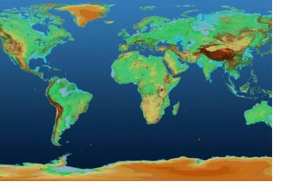
The German Aerospace Center (DLR) has released a 90-metre resolution global elevation model from its TanDEM-X mission for scientific data use. The data is free to download via the new Earth Observation Center (EOC) download service.
Digital Elevation Models (DEM) support disaster management efforts by allowing to map and modell natural hazards and risks that are influenced by topography such as floods or landslides. Elevation information is used, for instance, to assess where water will inundate the landscape. After an earthquake, damage to buildings might not be assessed correctly using optical satellite imagery as they might seem intact from above - information from a DEM can help determine whether buildings have collapsed or not.
For more background information, please see the "Data Application of the Month" page dedicated to digital elevation models.
The TanDEM-X model is a high-precision 3D representation of Earth’s terrain based on data from the German Earth observation mission TanDEM-X.
The German Aerospace Center (DLR) is responsible for the scientific use of the TanDEM-X data, the planning and the execution of the mission, the control of the two satellites and the generation of the digital elevation model together with Airbus Defense and Space, who built the satellite.
The TanDEM-X mission surveys the entire surface of the Earth by measuring the high point density and the high vertical accuracy. TanDEM-X data provides a highly reconfigurable platform for the demonstration of new SAR techniques and applications such as digital beamforming, single-pass polarimetric SAR interferometry, ATI (Along-Track Interferometry) with varying baseline, or super resolution.
Elevation models from different points in time can also be directly compared with each other in the map browser of the Earth Observation Center (EOC) Geoservice, which facilitates the discovery of traces of human activity, volcanic eruptions, or glacier movement between the dates that they were obtained.
Moreover, daily-updated satellite image mosaics, settlement masks, global snow cover, and ozone concentrations can be viewed in the map browser of the EOC Geoservice and can be directly integrated in user applications.
The TanDEM-X satellite is a replica of TerraSAR-X with minor enhancements. They are the first configurable SAR (synthetic aperture radar) interferometers in space. TanDEM-X receives location and position data from its twin satellite. It was designed for a lifetime of five years and has been flying in formation with TerraSAR-X since 2010.

