![]()
United
Nations
Glissement de terrain

Definition
Facts and figures
Further information
UN-SPIDER Regional Support Offices with hazard-specific expertise
Related content on the Knowledge Portal
 on October 31, 2022. Image: Sentinel 2A (The International Charter Space and Major Disasters)")
Tropical Storm Nalgae (known as Paeng in the Philippines) unleashed floods and landslides in the Philippines, killing at least 45 people.
Provinces and cities in the south were hit the hardest by the storm. The Bangsamoro Autonomous Region in Muslim Mindanao (BARMM) was put under a state of emergency due to severe flooding.
Authorities reported that close to 185,000 people across the country were affected by the storm.
UNOOSA/UN-SPIDER requested the activation of the International Charter Space and Major Disaters on behalf of the Philippine Space Agency (PhilSA) and the National Disaster Risk Reduction and Management Council (NDRRMC).
read moreOrganization Title …")
Tropical Storm Megi (also known as Agaton) passed over the Philippines on 10 April, causing landslides and floods in its wake.
The storm struck the east and south coasts of the archipelago, particularly affecting Western Visayas, Eastern Visayas and Craga regions.
35,000 people were evacuated before the storm arrived, and it is estimated that as many as 200,000 have had to leave their homes since then to move to safer locations. Estimates suggest almost a million people may be affected by the disaster.
76 people have been reported killed due to floods and landslides, after rivers burst their banks and debris from hills was washed down, and villages near Baybay City have been badly affected.
UNOOSA/UN-SPIDER requested the activation of the International Charter Space and Major Disasters on behalf of the Philippine Space Agency (PhilSA) and the Philippine National Disaster Risk Reduction and Management Council (NDRRMC)
… read more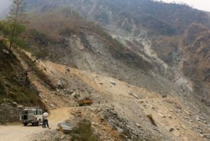
This article is a republished news article, created and originally published by the International Centre for Integrated Mountain Development (ICIMOD) under a Creative Commons license. Read the original article here.
Author: Utsav Maden, Knowledge Management and Communication Officer, ICIMOD
Nepal faces a double whammy of floods and landslides every year. Often considered a secondary hazard, landslides are usually triggered by incessant rainfall falling upon hilly and unstable slopes in Nepal’s predominantly mountainous terrain. As Nepal lies at the cusp of the Indian and Tibetan tectonic plates, it is more susceptible to earthquakes and resulting landslides. Unplanned road building and construction along unstable mountain slopes on relatively young mountain terrain…
read moreRegional Support Offices mentioned:24/01/2023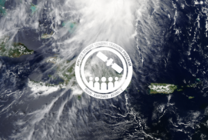
The training date is in the past. However, videos and resources of the training can be accessed here.
Small island nations are highly vulnerable to climate change and natural disasters; among them hurricanes, cyclones, and other violent storms. These disasters can lead to severe flooding, landslides, and, in the worst cases, can result in the loss of life and property. In addition, a rise in the global mean sea level places island nations at a higher risk for permanent submersion of land, coastal erosion, coastal ecosystem loss or change, salinization, and impeded drainage.
This three-part training series will focus on small island nations while introducing the data, methods, and tools useful for monitoring natural hazards. Case studies will be used to demonstrate methodologies applying satellite and…
read more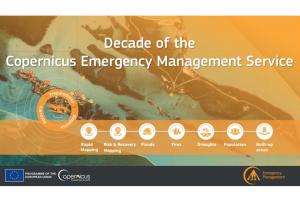
Implementing science to save lives: A Decade of the Copernicus Emergency Management Service
The Copernicus Emergency Management Service (CEMS) celebrates a decade of operation as a world leader in emergency mapping, early warning tools and open-access disaster information.
For the past ten years, CEMS has provided a global service as a fully operation emergency mapping service at no cost to users and with open access data.
Some highlights on the contribution of CEMS in global disaster risk management activities:
- 576 Rapid Mapping Activations with 5,500+ maps delivered
- Designed and implemented the world’s first Global Flood Monitoring tool
- Ten years of wildfire forecasts up to ten days into the future
- Average of 200+ flood and 500+ flash flood notifications to Member States and authorised users each year
- Offers a current and historical database of 7,000+ drought episodes since 1950
…
read more22/06/2022 Publishing institution:
-
Publishing institution:
")
The tool has the potential to be a significant way to safeguard people against fatal natural disasters: around 25-50 people are killed by landslides each year in the United States alone, and the global annual death toll is estimated in thousands.
This new tool strives for two things: first, it aims for early prediction, meaning more than a couple of days in advance, in the hope to undertake some remediation to avert the landslide.
And due to this, the most accurate projections of the exact site of an oncoming landslide now occur a year in advance.The second critical element of the team's new tool is its ability to forecast landslides a month in advance on a regional scale.
The innovative aspect of the team'…
read more14/03/2022 The Copernicus DEM is a Digital Surface Model (DSM) which represents the surface of the Earth including buildings, infrastructure, and vegetation. The Copernicus DEM is provided in 3 different instances. Two worldwide coverages at 90m (GLO-90) and 30m (GLO-30) resolution are openly available to the public for download via the PANDA Catalogue and FTP. A further European coverage (EEA-10) is provided at 10m resolution, but data is restricted to eligible users who meet required access rights.Publishing institution:
-
The Copernicus DEM is a Digital Surface Model (DSM) which represents the surface of the Earth including buildings, infrastructure, and vegetation. The Copernicus DEM is provided in 3 different instances. Two worldwide coverages at 90m (GLO-90) and 30m (GLO-30) resolution are openly available to the public for download via the PANDA Catalogue and FTP. A further European coverage (EEA-10) is provided at 10m resolution, but data is restricted to eligible users who meet required access rights.Publishing institution:
Term Parents
UN-SPIDER Regional Support Offices with hazard-specific expertise
![]()