The mission was headed by two experts from UN-SPIDER and included experts from UNEP, UNDP, the German Aerospace Centre (DLR), York University, Planet Action, the China National Space Administration and the Regional Centre for Mapping and Resources Development (RCMRD), which is one of the three UN-SPIDER Regional Support Offices in Africa.
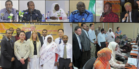
The mission included meetings with representatives from key government stakeholders including three Ministers. The mission included a half-day meeting to brief representatives from the various relevant government departments and to discuss cross-cutting issues related to the use of space-based information for disaster risk reduction and emergency response. The mission also included a one-day national workshop which was attended by over 100 representatives from the Government, NGOs, Academia, United Nations organisations and private companies.
The expert team became aware that the National Council for Civil Defence (NCCD) is the apex body in the Government to coordinate disaster management in the country. The Council is composed by 16 Ministries, the Governor of Khartoum State and the Civil Defense Administration. It the main decision maker in case of disasters;
Disaster Risk Management and Emergency Response efforts are conducted under the coordination of the Council and involve the Civil Defense, the Ministry of Irrigation and Water Resources, the Ministry of Health, the Meteorological Authority and other organizations. However, the focus is more on disaster response as opposed to disaster-risk reduction efforts;
The Mission also took note of the lack of effective links among government agencies when it comes of data and information sharing. In particular, there is an absence of a coordinated, government-driven, functional National Spatial Data Infrastructure (NSDI) for Sudan;
There are a number of key institutions within Government with competent, well trained professionals and technicians that are currently adept at use space-based data and geo-information technologies to derive value-added geospatial information products for DRR and ER, as is evident from their past and ongoing projects. For example the Dessert Locust Control Centre is a key example of using a combination of earth observation data with communication and navigation satellites data. Other institutes would include the Remote Sensing Authority (RSA), the Sudan Meteorological Authority (SMA), the Desert Locust Control Centre (LCC), National Survey and Mapping Authority and the Ministry of Agriculture;
There is a substantial amount of GIS data covering the entire country but it is not cohesive. The mission team could not get indication that any single agency currently has the entire baseline GIS data for the entire country which can be shared with all other departments and institutions involved in using of geospatial information.
Sudan is implementing the Regional Centre for Preparedness and Early Warning with assistance from the International Civil Defense Organization (ICDO);
Currently no Government institution is in the position to activate the International Charter Space and Major Disasters.
Based on its findings, the mission team identified a number of activities that could lead to improved use of space-based information and technology. Among them:
- The NCCD should enact policies and implement strategies targeting disaster risk reduction as a way to improve early warning, preparedness, response and mitigation, pillared on space technology applications;
- The NCCD should find ways to improve institutional arrangements and coordination to ensure effective cooperation and contribution of all the stakeholders to implement decisions of the Council.
- Government Ministries should design and implement clear mechanisms for information management and sharing, including the development of the country’s National Spatial Data Infrastructure (NSDI). A National Geo-information Committee should be formed based on the protocol established by RCMRD for its member states to improve coordination, cooperation and networking of the organisations involved in generating geospatial information;
- The government should take steps to link with UN-SPIDER and with mechanisms such as the International Charter: Space and Major Disasters as a way to access relevant information for disaster risk reduction, strengthen early warning systems and monitor disaster’s impact to provide effective emergency response;
- The NCCD should strengthen institutional capacities at the federal and state levels to consolidate the application of space technologies and geo-information.
- Awareness raising activities targeting the decision makers at high and mid-levels need to be conducted focusing on the benefits of space-based information in the context of emergency response and disaster-risk management;