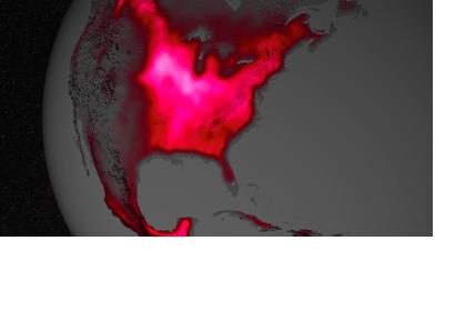
Satellite sensor data show that the crops in the Midwest region of the United States have highest photosynthetic activity, compared to other agricultural regions. Sensors are detecting the fluorescence glow of the chlorophyll released by the crops during the photosynthesis.
Joanna Joiner of NASA's Goddard Space Flight Center in Greenbelt, Md. demonstrated in 2013 that fluorescence data can be extracted from existing satellite data. Luis Guanter of the Freie Universität Berlin used the new data to predict photosynthesis levels of crops. According to co-author Christian Frankenberg of NASA's Jet Propulsion Laboratory in Pasadena, California, "The paper shows that fluorescence is a much better proxy for agricultural productivity than anything we've had before. This can go a long way regarding monitoring - and maybe even predicting - regional crop yields."
The researchers used images from the Global Ozone Monitoring Experiment 2 (GOME-2) on Metop-A European Meteorological satellite for their report. The analysis showed that the fluorescence glow from the U.S. Corn Belt in July is almost double the glow from plants in the Amazon. A further comparison with the on ground measurement systems and yield statistics were a match to the prediction made from the satellite data.
The new method could be of great importance for monitoring areas where food security is an issue. As UN-SPIDER reported back in February, ESA is already planing to launch a satellite with a special sensor in order to create more detailed vegetation maps.

