• English
  • Español
  • Français

United
Nations


Office for Outer Space Affairs
UN-SPIDER Knowledge Portal

  • Home
  • About Us
    • What is UN-SPIDER?
    • About UNOOSA
    • Publications
    • Jobs
    • Meet the Team
    • Contact
  • Space Application
    • Satellite Technology
    • Emergency Mechanisms
    • Recovery Mechanisms
    • International Asteroid Warning Network
    • Space Mission Planning Advisory Group
    • International Space Weather Initiative
    • Space Technologies in the UN
    • User Stories
  • Links & Resources
    • Data Applications
      • Disaster Recovery
    • Data Sources
    • GIS and Remote Sensing Software
    • Online Learning Resources
    • Institutions
  • Risks & Disasters
    • Disaster Risk Management
    • Early Warning Systems
    • Emergency and Disaster Management
    • Natural Hazards
    • Sendai Framework
    • The UN and Disaster Risk Management
    • The UN and Early Warning
    • The UN and Disaster Management
  • Advisory Support
    • Advisory Missions
    • Emergency Support
    • Virtual Advisory Support
    • Recommended Practices
    • Training Activities
    • Practical Uses
  • Network
    • Regional Support Offices
    • GP-STAR
    • MHEWS
    • IWG-SEM
  • Projects
    • SPEAR
    • SEWS-D
    • EvIDENz
    • Flood GUIDE
  • News & Events
    • News
    • Events Calendar
    • UN-SPIDER Events Archive

Breadcrumb

  • Home
  • News and Events
  • View Active News
  • Precipitation Monitoring: On-ground Research Complements Satellite Accuracy
  • Precipitation monitoring: On-ground research complements satellite accuracy

Precipitation monitoring: On-ground research complements satellite accuracy

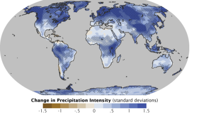
Estimation map of climate change induced increase in precipitationInrease in precipitation

As UN-SPIDER reported, NASA is preparing for the launch of the Global Precipitation Measurement (GPM) satellite in the end of February. The Satellite will be mainly used for rain- and snowfall observation and forecasting.

Scientists of the University of Alabama in Huntsville are conducting basic on the ground research of raindrop and snowflakes sizes and shapes, which they hope will provide a accuracy baseline that is to be scaled up to satellite data. Knowledge of the basic variations of snow- and rainfall will help calibrate the satellite instruments and reduce the error rate for larger areas of observation either by radars or satellite.

The instruments on the satellite – advanced radars and radiometer systems to measure precipitation from space will provide the core of next generation earth observation and fill the observation information gaps left from the ground level reserach. The data collected by the satellite will be validated by the ground research station at the University of Alabama and then used as a reference for other measurements for better understanding of water and energy cycles, for example. 

The gathered information will be used globally to improve forecasting of extreme events like storms and floods.
Science Daily
Fri, 7 Feb 2014 - 10:20

Footer menu

  • Contact
  • Terms of Use

User account menu

  • Log in