![]()
United
Nations
Feu de forêt
, processed by ESA, CC BY-SA 3.0 IGO.")
Definition
Facts and figures
Further information
UN-SPIDER Regional Support Offices with hazard-specific expertise
Related content on the Knowledge Portal
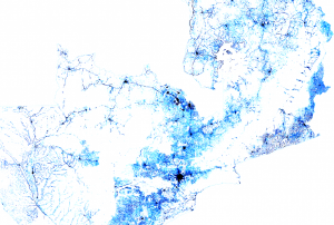 Facebook Connectivity Lab in collaboration with the Center for International Earth Science Information Network (CIESIN) at Colombia University combines machine vision AI with satellite imagery and census information to create population density maps. With the integration of demographic information, specifically related to age and gender, these maps collectively provide information on both the location and the demographic of a population in a certain country. The population density maps cover the majority of countries around the world.Publishing institution:
Having reliable and timely population distribution data can make a life or death difference for individuals facing crises or living in conflict-ridden regions. These data are also essential for development decision-making and planning and for monitoring progress towards the UN Sustainable Development Goals (SDGs) established by the international community. We need to know where people are located, what conditions they are facing, what infrastructure is available, and what basic services they can access. We also need to ensure that no one is left off the map in pursuit of meeting the SDGs.
Gridded population data, which often use remote sensing inputs to improve the spatial allocation of population within a country, are vital for all these purposes. Together with the growing variety of applications that require spatial population data, there is now a bewildering array of population grids, and users need to know which ones are most suitable for their applications…
read more
Fires are a growing concern, especially in regions with longer fire seasons, expanded wildland/urban interfaces, and severe and frequent droughts. Anthropogenic fires are commonly used to clear grassland and agricultural land prior to the planting season, and forests are often cleared using fires so the land can be repurposed for other uses. Whether naturally-occurring or anthropogenic, fires produce a significant change in the structure and reflectance of vegetation and soil properties and atmospheric chemistry. Remote sensing can be used to monitor pre-, during-, and post-fire conditions; including weather and climate conditions, fuel characterization, fire risk, smoke detection, monitoring, and forecasting, fire behavior, and the post-fire landscape. This 6-part, intermediate training will provide lectures and case studies focused on the use of Earth observations for operational fire monitoring: pre-, during-, and post-event.
Course Format
The…
read more
EUROGEO 2021, the annual meeting and conference of the European Association of Geography will be held online on 22 and 23 April 2020. These two days will be dedicated to the contribution that the community of geographers can bring to global challenges by sharing knowledge about the important United Nations aim – the 17 Sustainable Development Goals (SDGs).
In 2015, the United Nations approved these objectives, covering all possible social, economic and natural aspects, both in a global and local space. Most of them are related to geography and seek to promote a multidimensional model of development that can guarantee sustainability. The identified priority is zero…
read more
In recent years, the frequency and severity of natural hazards has increased dramatically. This development has escalated the risk of disasters and their devastating impact on the environment and communities around the world. Earth observation (EO) data has the potential to mitigate the risks of disasters and support all phases of the disaster management cycle. The international community has created various mechanisms to facilitate the use of EO data for disaster management, such as the International Charter Space and Major Disasters. The Algerian Space Agency (ASAL) has provided EO data to the International Charter for almost two decades.
The International Charter refers to a consortium of space agencies, national and regional disaster monitoring organizations that utilize EO data for…
read moreRegional Support Offices mentioned:13/04/2021
Increasing in frequency and severity, wildfires have had a devastating impact in several areas around the world in recent years. The effects of wildfires pose a particular risk to the environment and communities in the Latin America and Caribbean (LAC) region. In order to mitigate the effects of wildfires and support wildfire risk management in the region, the Joint Research Centre (JRC) of the European Commission (EC) recently launched country profiles under the Global Wildfire Information System (GWIS).
A wildfire refers to “an unplanned, unwanted wild land fire”. Wildfires are both caused by man-made activity (slash/burn land clearing) and natural events (lightning or extreme drought). The likelihood of a wildfire increases dramatically in the dry season and during…
read more30/03/2021
The head of the UN-SPIDER Bonn office and a visiting scientist from the Universidad Católica de Manizales will conduct a webinar entitled “Introduction to Satellite Products and Services for the Management of Forest Fires” (in Spanish). The aim of this webinar is to facilitate the use of space-based information for disaster management and emergency response, in particular to monitor and forecast forest fires.
The recording of the webinar is available online.
The webinar will discuss the following topics:
-
Introduction to UN-SPIDER and UNOOSA
-
Introduction to satellite atmospheric observations of fire emissions
-
State-of-the-art Copernicus operational data sets for monitoring smoke and fire emissions to the atmosphere
-
Copernicus Forest Fire Hazard and ECMWF data offering
- …
-
-

In recent years, the world witnessed many devastating wildfires with disastrous impacts on the environment as well as on its population. In the past satellite- and airplane-based radar instruments have been used to detect wildfires and observe their temporal progression and the damage caused. A new scientific project supported by the Earth Applied Sciences Disasters programme at NASA uses radar data for a new approach in order to decipher where and how well landscapes recover in the years after major fires. This information is essential for forest and fire managers to manage future risks.
Radar instruments are vital for tracking fire fronts and burn scars during and shortly after fire has ravaged a landscape. They are very helpful as they are able to observe by day or night and can see land through clouds and smoke. Synthetic aperture radar (SAR) instruments, carried on the Sentinel-1 satellites, send out pulses of microwaves that bounce off the Earth’s surfaces. The…
read more12/02/2021
In recent years, various regions of the world have been experiencing severe forest fires which, in some cases, are triggering major losses. The Mario Gulich Institute on High Level Studies on Outer Space, the Latin American Network on Remote Sensing of Forest Fires (RedLaTIF), the National Space Research Institute of Brazil (INPE), Mexico's National Biodiversity Commission (CONABIO), Argentina's National Agricultural Technology Institute (INTA), the Friends of Nature NGO of Bolivia (FAN), and UN-SPIDER are joining forces to deliver a virtual training course on the use of Google Earth Engine for an improved management of space-based and geospatial information related to forest fires.
The virtual training course will be carried out…
read more04/01/2021
The United Nations Office for Outer Space Affairs (UNOOSA) and the National Aeronautics and Space Administration of the United States Government (NASA) signed a landmark Memorandum of Understanding (MoU) on 17 December 2020 pledging cooperation in areas of science and technology to support the peaceful uses of outer space.
The MoU brings together NASA's wealth of open-source spacecraft data, tools, and expertise and UNOOSA's unique position as the only UN entity dedicated to outer space affairs, to expand global opportunities to leverage the benefits of space. The partners will design capacity-building programmes, particularly for institutions in countries that do not yet have or that are developing space capabilities, to help them access space.
Together, UNOOSA and NASA will develop ways to leverage the Artemis programme as part of UNOOSA's Access to Space 4 All Initiative, which offers opportunities for international researchers and institutions, especially in…
read more11/01/2021
Term Parents
UN-SPIDER Regional Support Offices with hazard-specific expertise
![]()