• English
  • Español
  • Français

United
Nations


Office for Outer Space Affairs
UN-SPIDER Knowledge Portal

  • Inicio
  • Sobre nosotros
    • Sobre ONU-SPIDER
    • Acerca de UNOOSA
    • Publicaciones
    • Ofertas de trabajo
    • Conozca el Equipo
    • Contacto
  • Aplicación Espacial
    • Guías Tecnológicas
    • Mecanismos de Emergencia
    • Mecanismos de Recuperación
    • Red Internacional de Alerta de Asteroides
    • Grupo Asesor para la Planificación de Misiones Espaciales
    • Iniciativa Internacional sobre Meteorología Espacial
    • Tecnologías Espaciales en la ONU
    • Historias de Usuarios
  • Enlaces y Recursos
    • Aplicación de datos del mes
      • Disaster Recovery
    • Fuentes de Datos
    • SIG y Software de Percepción Remota
    • Recursos de capacitación en línea
    • Instituciones
  • Riesgos y Desastres
    • Gestión del Riesgo de Desastres
    • Alerta temprana
    • Gestión de Desastres y Emergencias
    • Amenazas Naturales
    • El Proceso de la Reducción de Desastres Post-2015
    • La ONU y la Gestión del Riesgo de Desastres
    • La ONU y Alerta Temprana
    • La ONU y la Gestión de Desastres
  • Asesoría
    • Misiones de Asesoría
    • Apoyo en caso de Emergencia
    • Asesoría Virtual
    • Prácticas Recomendadas
    • Actividades de Entrenamiento
    • Usos Prácticos
  • Redes
    • Oficinas Regionales de Apoyo
    • GP-STAR
    • IN-MHEWS
    • IWG-SEM
  • Proyectos
    • SPEAR
    • FOSAT-S
    • EvIDENz
    • Flood GUIDE
  • Noticias y Eventos
    • Noticias
    • Eventos
    • Eventos pasados
  • Admin
    • SAM Items

Breadcrumb

  • Home
  • NASA: Examining Extratropical Cyclones To Understand Cloud-storm Relationship
  • NASA: Examining extratropical cyclones to understand cloud-storm relationship

NASA: Examining extratropical cyclones to understand cloud-storm relationship

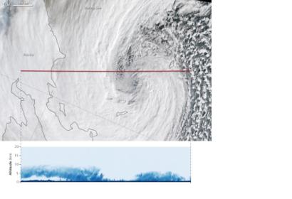
VIIRS captured this view of the Bering Sea superstorm on 8 NovemberThe Visible Infrared Imaging Radiometer Suite (VIIRS) captured this view of the Bering Sea superstorm on 8 November 2014 (image: NASA)

NASA's scientists are researching new information about the Earth's hydrologic cycle by examining satellite radar imagery of extratropical cyclones in the Bering Sea.

Cyclones constitute one of the most widely spread and powerful storm systems on our planet and they generate the majority of fresh water collected at middle and high latitudes. While the phenomena that originates extratropical cyclones is well known, the elements of cloud features constituting these storms are not completely explained.

Consequently, NASA's experts are examining the cloud-storm relationship by looking at the fine-scale features of cyclones in order to assess the feedback on the storm strength and life cycle. Radar technology, such as those of NASA's CloudSat, allows experts to detect the reflections from cloud droplets and ice particles. The higher the amount of water and ice contained in the cloud, the more the energy that the cloud reflects back to the radar. The added value of CloudSat radar is to enable detailed analysis of the middle and upper portions of winter storm clouds, which are invisible with other radars, as well as the intense snow bands reaching the surface.
NASA
Fri, 28 Nov 2014 - 09:34

Footer menu

  • Contact
  • Terms of Use

User account menu

  • Log in