• English
  • Español
  • Français

United
Nations


Office for Outer Space Affairs
UN-SPIDER Knowledge Portal

  • Inicio
  • Sobre nosotros
    • Sobre ONU-SPIDER
    • Acerca de UNOOSA
    • Publicaciones
    • Ofertas de trabajo
    • Conozca el Equipo
    • Contacto
  • Aplicación Espacial
    • Guías Tecnológicas
    • Mecanismos de Emergencia
    • Mecanismos de Recuperación
    • Red Internacional de Alerta de Asteroides
    • Grupo Asesor para la Planificación de Misiones Espaciales
    • Iniciativa Internacional sobre Meteorología Espacial
    • Tecnologías Espaciales en la ONU
    • Historias de Usuarios
  • Enlaces y Recursos
    • Aplicación de datos del mes
      • Disaster Recovery
    • Fuentes de Datos
    • SIG y Software de Percepción Remota
    • Recursos de capacitación en línea
    • Instituciones
  • Riesgos y Desastres
    • Gestión del Riesgo de Desastres
    • Alerta temprana
    • Gestión de Desastres y Emergencias
    • Amenazas Naturales
    • El Proceso de la Reducción de Desastres Post-2015
    • La ONU y la Gestión del Riesgo de Desastres
    • La ONU y Alerta Temprana
    • La ONU y la Gestión de Desastres
  • Asesoría
    • Misiones de Asesoría
    • Apoyo en caso de Emergencia
    • Asesoría Virtual
    • Prácticas Recomendadas
    • Actividades de Entrenamiento
    • Usos Prácticos
  • Redes
    • Oficinas Regionales de Apoyo
    • GP-STAR
    • IN-MHEWS
    • IWG-SEM
  • Proyectos
    • SPEAR
    • FOSAT-S
    • EvIDENz
    • Flood GUIDE
    • CommonSpace Initiative
    • Tonga Pilot Project
  • Noticias y Eventos
    • Noticias
    • Eventos
    • Eventos pasados

Breadcrumb

  • Home
  • India Uses Space Technology To Assess Cyclone Hudhud Damages
  • India uses space technology to assess Cyclone Hudhud damages

India uses space technology to assess Cyclone Hudhud damages

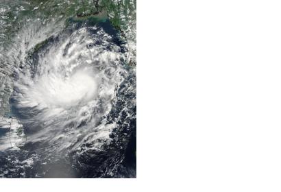
Satellite data to assess cylone Hudhud damageIndia employed satellite technology to assess cylone Hudhud damage (Image:NASA)

Andhra Pradesh Chief Minister Chandrababu Naidu has directed the Hyderabad National Remote Sensing Centre (NRSC) to use GIS, GPS and remote sensing instruments to detect the detrimental effects caused by Cyclone Hudhud in the region. The NRSC employed geo-tagging to create a map of the damages, in order to facilitate the action of the national disaster response forces (NDRF) deployed to provide support relief.

The cyclone hit India's eastern coast on the weekend, with heavy rains and winds at 170/180 km ph of speed. Although evacuation plans have been implemented after NASA's cyclone alert on 8 October, the storm generated severe consequences, including property and live losses and communication systems' disruption. According to Naidu "the government was able to reduce loss of life due to the precautionary measures taken".

Additionally, India has received relevant satellite-based information through the International Charter: Space and Major Disasters. The international mechanism for satellite-based emergency support was triggered on 12 October 2014 by the Indian Space Research Organisation ISRO. The resulting maps and products will be available for download on the International Charter's website.

The Indian government launched an app for crowdsourcing photos of damages and allocate personnel in the affected areas. Also, a facebook page was created describing the steps necessary to share geo-tagged images through social medias.
The Times of India
Mon, 13 Oct 2014 - 11:02
India

Footer menu

  • Contact
  • Terms of Use

User account menu

  • Log in