• English
  • Español
  • Français

United
Nations


Office for Outer Space Affairs
UN-SPIDER Knowledge Portal

  • Inicio
  • Sobre nosotros
    • Sobre ONU-SPIDER
    • Acerca de UNOOSA
    • Publicaciones
    • Ofertas de trabajo
    • Conozca el Equipo
    • Contacto
  • Aplicación Espacial
    • Guías Tecnológicas
    • Mecanismos de Emergencia
    • Mecanismos de Recuperación
    • Red Internacional de Alerta de Asteroides
    • Grupo Asesor para la Planificación de Misiones Espaciales
    • Iniciativa Internacional sobre Meteorología Espacial
    • Tecnologías Espaciales en la ONU
    • Historias de Usuarios
  • Enlaces y Recursos
    • Aplicación de datos del mes
      • Disaster Recovery
    • Fuentes de Datos
    • SIG y Software de Percepción Remota
    • Recursos de capacitación en línea
    • Instituciones
  • Riesgos y Desastres
    • Gestión del Riesgo de Desastres
    • Alerta temprana
    • Gestión de Desastres y Emergencias
    • Amenazas Naturales
    • El Proceso de la Reducción de Desastres Post-2015
    • La ONU y la Gestión del Riesgo de Desastres
    • La ONU y Alerta Temprana
    • La ONU y la Gestión de Desastres
  • Asesoría
    • Misiones de Asesoría
    • Apoyo en caso de Emergencia
    • Asesoría Virtual
    • Prácticas Recomendadas
    • Actividades de Entrenamiento
    • Usos Prácticos
  • Redes
    • Oficinas Regionales de Apoyo
    • GP-STAR
    • IN-MHEWS
    • IWG-SEM
  • Proyectos
    • SPEAR
    • FOSAT-S
    • EvIDENz
    • Flood GUIDE
    • CommonSpace Initiative
  • Noticias y Eventos
    • Noticias
    • Eventos
    • Eventos pasados

Breadcrumb

  • Home
  • Viet Nam To Boost Use of Satellite Technology For Agriculture
  • Viet Nam to boost use of satellite technology for agriculture

Viet Nam to boost use of satellite technology for agriculture

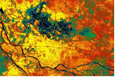
Vegitation Map of Mekong DeltaMekong Delta, Vietnam (Image: ESA)

Viet Nam’s Deputy Minister of Agriculture and Rural Development, Le Quoc Doanh, announced last week plans for Viet Nam to use remote sensing technology in order to boost crop production in the Red River and Mekong River Deltas and to expand the project to include the monitoring of water and forest resources.  

"As one of the countries that are most vulnerable to the impacts of climate change, natural disaster forecasting and management play an important role in mitigating losses," Doanh said.

Over the past two years, Viet Nam’s Agricultural Ministry has worked in co-operation with the Swiss Agency for Development and Co-Operation in applying remotely sensed satellite imagery provided by European satellites to analyze the production of rice in the provinces of Nam Dinh and Soc Trang leading to a productivity forecast with an accuracy of over 90 percent.

The data from the satellite images has been used by the agriculture ministry to develop land-use maps in 11 provinces along the Red River delta to improve both agriculture and forest management efforts across the country and has lead to the development of forest fire warning system. 
Saigon
Mon, 4 Aug 2014 - 12:50

Footer menu

  • Contact
  • Terms of Use

User account menu

  • Log in