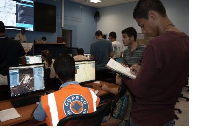
The United States and Honduras are joining efforts in Tegucigalpa and Soto Cano Air Base, June 9-12, to demonstrate and assess a mapping tool designed to revolutionize the way governmental and non-governmental organizations from all over the world collaborate in response to disasters and humanitarian crises.
Known as GeoSHAPE, the open-source, open-standard software, integrates data from multiple sources and displays it in a dynamic Internet-based map to provide situational awareness and facilitate the decision making process. “GeoSHAPE bridges the geospatial information sharing gaps we witnessed during the international response to the 2010 earthquake in Haiti, providing a tool for military and civil organizations, local and international, to efficiently coordinate their activities and, in turn, save more lives,” says Juan Hurtado, science advisor to the U.S. Southern Command (USSOUTHCOM).
This two-year technology development effort will be put through the test during a simulated hurricane event impacting Central America and requiring a large multi-organizational response. Role players in this hypothetical scenario will include Honduras’ Permanent Contingency Commission (COPECO), the local Red Cross, Plan Internacional (local non-governmental organization) and U.S. Joint Task Force-Bravo (JTF-B), among other organizations that usually respond to these events.
The GeoSHAPE solution comprises a web-based platform for creating, updating and sharing geospatially tagged events, as well as a mobile application for capturing data and photos in the field. Through these tools, organizations collaboratively create a picture of both the resources at hand and the extent of the damage. The availability of hospitals, helicopter landing zones, food and medical supplies, the condition of roads and bridges, and the deployment of rescue personnel to affected areas, among other key elements are plotted in a map that authorized users can see from anywhere in the world. The level of fidelity that this tool will offer will prevent redundancy of relief efforts, facilitate informed decision making among aid and resource planners, and alleviate congestion at logistical hubs.
The development of GeoSHAPE is part of a technology project sponsored by the U.S. Department of Defense’s Office of the Deputy Assistant Secretary of Defense for Emerging Capabilities and Prototyping and managed by the USSOUTHCOM Science, Technology and Experimentation Division. Other organizations involved in the program are the U.S. Army Engineer Research and Development Center (ERDC), the U.S. Department of State’s Humanitarian Information Unit, the Pacific Disaster Center, and LMN Solutions, an information technology company.
Throughout the years, the relationship between USSOUTHCOM’s Science, Technology and Experimentation Division, JTF-B and Honduras’s COPECO has proven successful in the development and implementation of technologies such as the Pre-positioned Expeditionary Assistance Kits (PEAK), a modular system that provides potable water, renewable energy, situational awareness, as well as local and global communications to first responders during humanitarian assistance and disaster relief operations.
After the final demonstration and evaluation in Honduras, if GeoSHAPE proves to add value to the response to disasters and humanitarian crises, it will be integrated with the Pacific Disaster Center’s DisasterAWARE platform, which provides continuously updated hazard information worldwide and functions as a hub for accessing, updating and sharing relevant data before, during and after a disaster.
According to Hurtado, disaster relief and humanitarian assistance are only two of the many potential applications for the GeoSHAPE developed capability, which can also be used in any situation where individuals or organizations need to create and share geospatial information, such as peacekeeping missions and border security, as well as many others.

