The mission team comprised ten experts from various institutions including UNOOSA, United Nations University (UNU), United Nations Environmental Programme (UNEP), National Space Research and Development Agency (NASDRA), MetOffice UK, National Disaster Risk Reduction of China (NDRCC), Secure World Foundation and the University of Free State.
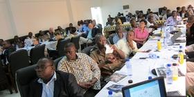
The mission was conducted through visits to different national and international institutions and organisations involved in disaster risk management, emergency response and the use of satellite data. These included various governmental departments and ministries. Additionally, UN-SPIDER organised a national workshop on 28 November 2014. More than 40 stakeholders from academia, ministries, emergency services and international organisations were introduced to applications of remote sensing for disaster risk management including flood mapping. They were also informed about existing international mechanisms such as the International Charter "Space and Major Disasters" that make available satellite information for support emergency response as well as on NADMO's role in the coordination of disaster management in Ghana. Various group discussions allowed participants to exchange on the current and potential use of space-based technology and the role for disaster management in each organisation. The mission was wrapped up with a debriefing of NADMO staff and its national coordinator presenting main observations and recommendations made by the mission team.
- Disaster Management Plan and Contingency Plans are in place but the crucial role of geospatial information needs to be enhanced. The National Disaster Management Authority recently started to build capacity for working with geospatial information
- National Spatial Data Infrastructure (NSDI) is already on the agernda of relevant authorities and organisations in Ghana
- There is a need for an permanent operational Geographic Information unit for disaster response, with 24/7 alertness capacity
- Ghana already has a great national as well as regional capacity on Space technologies and geospatial information. This support should be used for improvements in the use of space-based information for disaster management.
- Prioritize the potential of space based information and geospatial data at policy making level
- Establish a centrally organised National Spatial Data Infrastructure to support the work of NADMO
- Raise awareness of the availability of satellite imagery, e.g. through the International Charter Space and Major Disasters
- Explore the use of open source Geographic Information System/Remote Sensing software
- Make use of existing international partners: ITC, FEMA, Universities, UN-SPIDER