• English
  • Español
  • Français

United
Nations


Office for Outer Space Affairs
UN-SPIDER Knowledge Portal

  • Inicio
  • Sobre nosotros
    • Sobre ONU-SPIDER
    • Acerca de UNOOSA
    • Publicaciones
    • Ofertas de trabajo
    • Conozca el Equipo
    • Contacto
  • Aplicación Espacial
    • Guías Tecnológicas
    • Mecanismos de Emergencia
    • Mecanismos de Recuperación
    • Red Internacional de Alerta de Asteroides
    • Grupo Asesor para la Planificación de Misiones Espaciales
    • Iniciativa Internacional sobre Meteorología Espacial
    • Tecnologías Espaciales en la ONU
    • Historias de Usuarios
  • Enlaces y Recursos
    • Aplicación de datos del mes
      • Disaster Recovery
    • Fuentes de Datos
    • SIG y Software de Percepción Remota
    • Recursos de capacitación en línea
    • Instituciones
  • Riesgos y Desastres
    • Gestión del Riesgo de Desastres
    • Alerta temprana
    • Gestión de Desastres y Emergencias
    • Amenazas Naturales
    • El Proceso de la Reducción de Desastres Post-2015
    • La ONU y la Gestión del Riesgo de Desastres
    • La ONU y Alerta Temprana
    • La ONU y la Gestión de Desastres
  • Asesoría
    • Misiones de Asesoría
    • Apoyo en caso de Emergencia
    • Asesoría Virtual
    • Prácticas Recomendadas
    • Actividades de Entrenamiento
    • Usos Prácticos
  • Redes
    • Oficinas Regionales de Apoyo
    • GP-STAR
    • IN-MHEWS
    • IWG-SEM
  • Proyectos
    • SPEAR
    • FOSAT-S
    • EvIDENz
    • Flood GUIDE
  • Noticias y Eventos
    • Noticias
    • Eventos
    • Eventos pasados

Breadcrumb

  • Home
  • ESA Water Satellites Track Triple Superstorms In Asia
  • ESA water satellites track triple superstorms in Asia

ESA water satellites track triple superstorms in Asia

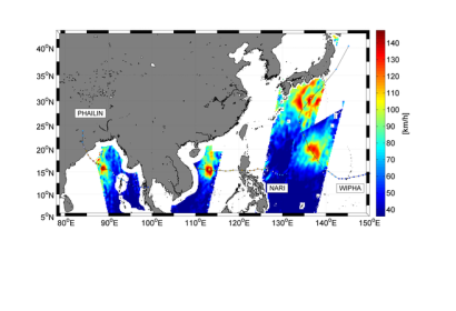
Wind speed readings from three different typhoons during 10–15 October 2013.Wind speed readings from three different typhoons during 10–15 October 2013. The image shows wind speeds up to 140 km/h (dark red) for Cyclone Phailin (left), Typhoon Nari (middle) and Typhoon Wipha (right).

ESA’s Soil Moisture and Ocean Salinity satellite, SMOS, captured three superstorms have been affecting Asia over the past three weeks. Cyclone Phailin began forming on 4 October in the Gulf of Thailand, before moving northwest across the Bay of Bengal and making landfall in northern India. The storm affected about 12 million people and claimed dozens of lives. Typhoons Nari and Wipha subsequently formed on 8 October: Nari west of the Philippines and Wipha east of Guam. Nari displaced tens of thousands of people in the Philippines and Vietnam, while Wipha lashed Japan’s east coast.

ESA elaborates on their website: "During all three superstorms, ESA’s Soil Moisture and Ocean Salinity satellite, SMOS, captured snapshots of surface wind speeds under the intense storms.SMOS carries a novel microwave sensor to capture images of ‘brightness temperature’. These images correspond to radiation emitted from Earth’s surface, which are then used to derive information on soil moisture and ocean salinity."

This video shows how SMOS makes sea surface observations during tropical storms:
ESA
Tue, 22 Oct 2013 - 12:46

Footer menu

  • Contact
  • Terms of Use

User account menu

  • Log in