• English
  • Español
  • Français

United
Nations


Office for Outer Space Affairs
UN-SPIDER Knowledge Portal

  • Inicio
  • Sobre nosotros
    • Sobre ONU-SPIDER
    • Acerca de UNOOSA
    • Publicaciones
    • Ofertas de trabajo
    • Conozca el Equipo
    • Contacto
  • Aplicación Espacial
    • Guías Tecnológicas
    • Mecanismos de Emergencia
    • Mecanismos de Recuperación
    • Red Internacional de Alerta de Asteroides
    • Grupo Asesor para la Planificación de Misiones Espaciales
    • Iniciativa Internacional sobre Meteorología Espacial
    • Tecnologías Espaciales en la ONU
    • Historias de Usuarios
  • Enlaces y Recursos
    • Aplicación de datos del mes
      • Disaster Recovery
    • Fuentes de Datos
    • SIG y Software de Percepción Remota
    • Recursos de capacitación en línea
    • Instituciones
  • Riesgos y Desastres
    • Gestión del Riesgo de Desastres
    • Alerta temprana
    • Gestión de Desastres y Emergencias
    • Amenazas Naturales
    • El Proceso de la Reducción de Desastres Post-2015
    • La ONU y la Gestión del Riesgo de Desastres
    • La ONU y Alerta Temprana
    • La ONU y la Gestión de Desastres
  • Asesoría
    • Misiones de Asesoría
    • Apoyo en caso de Emergencia
    • Asesoría Virtual
    • Prácticas Recomendadas
    • Actividades de Entrenamiento
    • Usos Prácticos
  • Redes
    • Oficinas Regionales de Apoyo
    • GP-STAR
    • IN-MHEWS
    • IWG-SEM
  • Proyectos
    • SPEAR
    • FOSAT-S
    • EvIDENz
    • Flood GUIDE
  • Noticias y Eventos
    • Noticias
    • Eventos
    • Eventos pasados
  • Admin
    • SAM Items

Breadcrumb

  • Home
  • Philippine Conference Stresses Importance of GIS For Disaster Risk Reduction
  • Philippine Conference stresses importance of GIS for disaster risk reduction

Philippine Conference stresses importance of GIS for disaster risk reduction

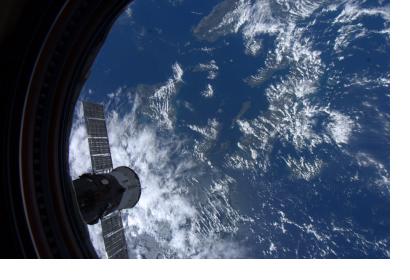
The Philippines seen from space

The recently- conducted GIS 8 Network 6th Conference and 14th Regional Assembly underscored the benefits of optimizing the use of geospatial information in support to disaster risk reduction and management. Held on November 15-16, 2012 at the Leyte Park Resort Hotel, the conference which was hosted by the Department of Agriculture Region 8, centered on the theme “GIS in Aid for Disaster Risk Reduction and Management.”

It was attended by more than a hundred participants from the different government agencies, academic institutions, people’s organizations, non-government organizations and several local government agencies, Mr. Rodel G. Macapañas, DA8 Info Officer 1 informed. Dir. Arsenio A. Fortin, DA-8 Regional Technical Director and Concurrent Regional Coordinator of the Region 8 Geographic Information System (GIS) Network, expressed his elation that the Network’s efforts in promoting awareness on the benefits of optimizing the use of geospatial information system in support to a wide range of rural development initiatives in Eastern Visayas, is paying off. Director Fortin said GIS is proven as an effective tool particularly in coming up with realistic resource-based planning and management.
PreventionWeb
Tue, 27 Nov 2012 - 08:38
Philippines

Footer menu

  • Contact
  • Terms of Use

User account menu

  • Log in