• English
  • Español
  • Français

United
Nations


Office for Outer Space Affairs
UN-SPIDER Knowledge Portal

  • Inicio
  • Sobre nosotros
    • Sobre ONU-SPIDER
    • Acerca de UNOOSA
    • Publicaciones
    • Ofertas de trabajo
    • Conozca el Equipo
    • Contacto
  • Aplicación Espacial
    • Guías Tecnológicas
    • Mecanismos de Emergencia
    • Mecanismos de Recuperación
    • Red Internacional de Alerta de Asteroides
    • Grupo Asesor para la Planificación de Misiones Espaciales
    • Iniciativa Internacional sobre Meteorología Espacial
    • Tecnologías Espaciales en la ONU
    • Historias de Usuarios
  • Enlaces y Recursos
    • Aplicación de datos del mes
      • Disaster Recovery
    • Fuentes de Datos
    • SIG y Software de Percepción Remota
    • Recursos de capacitación en línea
    • Instituciones
  • Riesgos y Desastres
    • Gestión del Riesgo de Desastres
    • Alerta temprana
    • Gestión de Desastres y Emergencias
    • Amenazas Naturales
    • El Proceso de la Reducción de Desastres Post-2015
    • La ONU y la Gestión del Riesgo de Desastres
    • La ONU y Alerta Temprana
    • La ONU y la Gestión de Desastres
  • Asesoría
    • Misiones de Asesoría
    • Apoyo en caso de Emergencia
    • Asesoría Virtual
    • Prácticas Recomendadas
    • Actividades de Entrenamiento
    • Usos Prácticos
  • Redes
    • Oficinas Regionales de Apoyo
    • GP-STAR
    • IN-MHEWS
    • IWG-SEM
  • Proyectos
    • SPEAR
    • FOSAT-S
    • EvIDENz
    • Flood GUIDE
  • Noticias y Eventos
    • Noticias
    • Eventos
    • Eventos pasados

Breadcrumb

  • Home
  • Ukraine Supports Cameroon Floods With Sich-2 Data
  • Ukraine supports Cameroon Floods with Sich-2 data

Ukraine supports Cameroon Floods with Sich-2 data

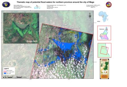
Thematic map of potential flood waters around the city of Maga

The UN-SPIDER Regional Support Office in Ukraine (Space Research Institute NASU-NSAU) supported the relief efforts following the September floods in Cameroon by providing flood maps. In September 2012, the northern part of Cameroon was hit by severe floods. Subsequently, the International Charter “Space and Major Disasters” was activated to acquire satellite images over affected regions. In the context of this activation, the UN-SPIDER Regional Support Office in Ukraine, the State Space Agency of Ukraine (SSAU) and the Center of the Special Information Receiving and Processing and the Navigating Field Control (CSIRP and NFC) coordinated their efforts in order to acquire images from the Ukrainian remote sensing satellite Sich-2 and deliver maps of flood waters. Two images were acquired: One of the city of Maga (10 September 2012) and one of the city of Garoua (15 September 2012).
International Charter
Mon, 1 Oct 2012 - 09:37
Ukraine Regional Support Office

Footer menu

  • Contact
  • Terms of Use

User account menu

  • Log in