  • English
  • Español
  • Français

United
Nations


Office for Outer Space Affairs
UN-SPIDER Knowledge Portal

  • Inicio
  • Sobre nosotros
    • Sobre ONU-SPIDER
    • Acerca de UNOOSA
    • Publicaciones
    • Ofertas de trabajo
    • Conozca el Equipo
    • Contacto
  • Aplicación Espacial
    • Guías Tecnológicas
    • Mecanismos de Emergencia
    • Mecanismos de Recuperación
    • Red Internacional de Alerta de Asteroides
    • Grupo Asesor para la Planificación de Misiones Espaciales
    • Iniciativa Internacional sobre Meteorología Espacial
    • Tecnologías Espaciales en la ONU
    • Historias de Usuarios
  • Enlaces y Recursos
    • Aplicación de datos del mes
      • Disaster Recovery
    • Fuentes de Datos
    • SIG y Software de Percepción Remota
    • Recursos de capacitación en línea
    • Instituciones
  • Riesgos y Desastres
    • Gestión del Riesgo de Desastres
    • Alerta temprana
    • Gestión de Desastres y Emergencias
    • Amenazas Naturales
    • El Proceso de la Reducción de Desastres Post-2015
    • La ONU y la Gestión del Riesgo de Desastres
    • La ONU y Alerta Temprana
    • La ONU y la Gestión de Desastres
  • Asesoría
    • Misiones de Asesoría
    • Apoyo en caso de Emergencia
    • Asesoría Virtual
    • Prácticas Recomendadas
    • Actividades de Entrenamiento
    • Usos Prácticos
  • Redes
    • Oficinas Regionales de Apoyo
    • GP-STAR
    • IN-MHEWS
    • IWG-SEM
  • Proyectos
    • SPEAR
    • FOSAT-S
    • EvIDENz
    • Flood GUIDE
    • CommonSpace Initiative
    • Tonga Pilot Project
  • Noticias y Eventos
    • Noticias
    • Eventos
    • Eventos pasados

Breadcrumb

  • Home
  • IGAC Researches Application of Satellite Imagery For Flooded Areas
  • IGAC researches application of satellite imagery for flooded areas

IGAC researches application of satellite imagery for flooded areas

Visualization of floods in the Cauca and Nechi rivers (north of Antioquia)

The Agustin Codazzi Geographic Institute (IGAC), host of UN-SPIDER's Regional Support Office in Colombia, conducted a case study to identify flooded areas in Colombia during the maximum rainfall period of the years 2010-2012. This activity was carried out in order to promote the importance of remote sensing techniques and the application of digital satellite imagery for the extraction of flooded areas. The researchers visualized and monitored the behavior of the phenomenon by visual interpretation of optical and radar sensor data.

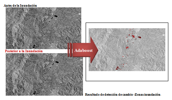
The digital products derived from the original images characterize and estimate the affected areas by making visible information on geomorphology, geology, topography, hydrology and soil units. These products are the results of the application of processing techniques, such as vegetation indexes and segmentation, the generation of topographic images of aspect or slope, the digital elevation model, and the application of the Adaboost algorithm for detecting changes. The researchers also used techniques of interferometry to generate displacement maps and morphometric maps to identify areas susceptible to flooding. The application of these techniques is being carried out by the group of Remote Sensing and Geographic Applications in remote areas such as the northern part of Antioquia and Valle del Cauca.

Attachment Tamaño
Application of the algorithm of change detection in the Cauca River (148.15 KB) 148.15 KB
Tue, 4 Sep 2012 - 07:54
Colombia
Agustin Codazzi Geographic Institute (IGAC)

Footer menu

  • Contact
  • Terms of Use

User account menu

  • Log in