When you work with geospatial information, there will be days when all of your scheduled meetings and regular everyday tasks seem insignificant. Your business will be focused in an area that you were not expecting, because every EO company is in the disaster monitoring business. It’s inevitable.
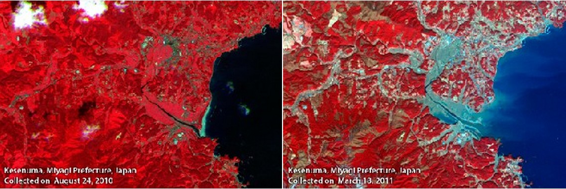
March 11, 2011 was definitely one of those days at RapidEye. A disastrous event occurring almost 9,000 kilometers from Brandenburg, Germany suddenly became the focus of many of RapidEye’s 130 team members.RapidEye’s Business Operations team immediately began scanning the RapidEye Library, an ever-growing archive of RapidEye satellite imagery, to see what images were available from before the event. In addition, there were impromptu discussions within the company as to how quickly the satellites could be tasked to cover Japan’s northeastern coast. Decisions on the management level were made, and the satellites were redirected to the affected areas.
The International Charter, an organization providing a unified system of space data acquisition and delivery, was activated by the Japan Aerospace Exploration Agency (JAXA), one of its eight international members. As a result, The Center for Satellite Based Crisis Information (ZKI), part of the German Aerospace Agency (DLR), contacted RapidEye for data. They requested as many before and after images of the eastern seaboard of Japan as could be acquired.
During the following week, RapidEye fielded calls and visits from many local and international media outlets. Television appearances about RapidEye and its involvement in Japan relief efforts were highlighted on German television through Tagesschau, Planetopia, the ZDF and RBB (Berlin/Brandenburg). Newspaper and online media outlets such as Spiegel Online, The Financial Times, Berlin’s Tagesspiegel and even New York-based CBS news were interested in RapidEye and its imagery. Much media attention was focused on EO imagery from providers such as RapidEye in regard to the benefits of using remote sensing to best direct relief efforts, as well as how change detection mapping can be produced with before and after imagery.
There is no question that natural disasters have been on the rise in recent years, but there will never come a time when an event of this magnitude will become routine. Every person and every company involved in the disaster management arena knows that these situations cannot be avoided. As a remote sensing company, we can only hope that through the technology we have access to, we can reduce the complexity of the situation for the people on the ground in Japan and elsewhere.