
Tsunami early warning systems rely on the timely and reliable acquisition of relevant data either from buoys at sea or from tide gauges in ports and its subsequent transmission to warning centres. Satellite communications provide a secure and reliable way to transmit that essential data to such warning centres. The Pacific Tsunami Warning System (PTWC), for example, uses satellite technology both to collect information on the height of waves and to transmit warnings to emergency centres in order to alert communities in case of tsunamis.
PTWC relies on the use of Deep-ocean Assessment and Reporting of Tsunami (DART) technology to detect and measure tsunami waves in the deep ocean. Each DART system is made of an anchored seafloor bottom pressure recorder (BPR) and a companion moored surface buoy. An acoustic link transmits data from the BPR on the seafloor to the surface buoy, which is equipped with two antennas. One antenna uses the Global Positioning System (GPS) to obtain precision location data while the other sends data on ocean levels to the PTWC through the Iridium Communications constellation of mobile communication satellites. When the BPR identifies an event, the system begins event mode transmissions, measuring values every 15 seconds during the initial few minutes, followed by measurements every minute. The system returns to standard transmission after 4 hours of 1-minute real-time transmissions if no further events are detected.
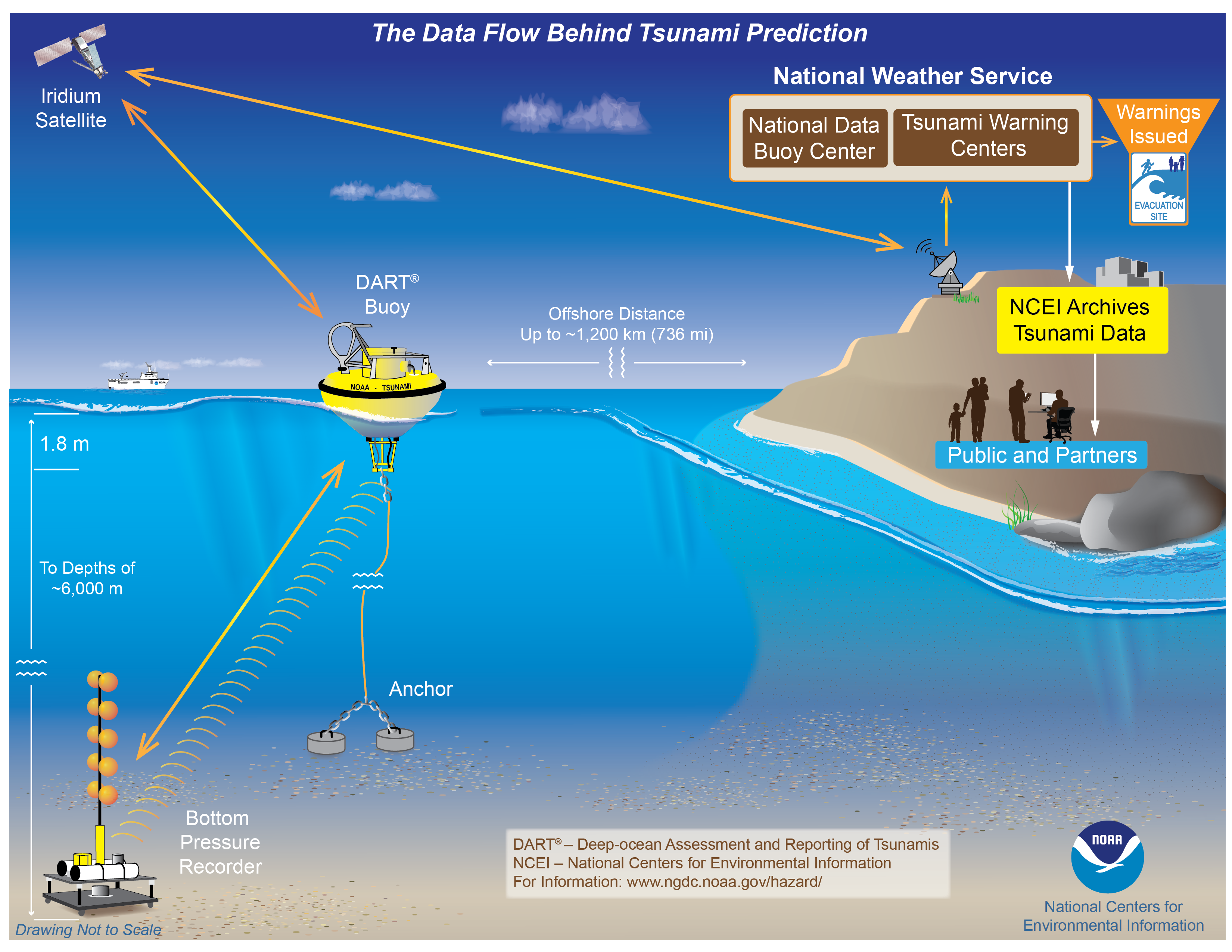
A significant capability of DART is the two-way communications between the BPR and the Tsunami Warning Centres (TWCs) using this Iridium commercial satellite communications system. The Iridium network, through its 66 cross-linked Low-Earth Orbit (LEO) satellites, provides high-quality, real-time data of the planet’s entire surface. Located at only 780 kilometres from the Earth, Iridium’s LEO network provides shorter transmission path, stronger signals, lower latency, and shorter registration time compared to geostationary orbit (GEO) satellites. In space, each Iridium satellite is linked to up to four others creating a dynamic network that routes traffic among satellites to ensure global coverage, even where traditional local systems are unavailable.

Image: IRIDIUM.
Once the data is forwarded from the BPR to an Iridium satellite, the satellite transmits it to the PTWC. Once the experts at the PTWC analyze this data, they can issue tsunami warnings to notify emergency managers, the public, and other partners about the potential for a tsunami following a possible tsunami-generating event.
Compared to terrestrial communications, satellite communications are highly reliable as they are not affected by extreme events that happen on Earth. The National Oceanic and Atmospheric Administration (NOAA), which operates the PTWC, relies specifically on commercial Iridium satellites to carry the signals because the Iridium constellation offers the capability for two-way data transmission. Through Iridium, PTWC experts not only receive data from the DART buoys but can also send signals to the buoys to upgrade software, perform tests or to reboot stations when the equipment is not working properly.
A more in-depth and technical overview of the DART system can be found in the DART programme descriptions and on the DART technology webpage. Real-time DART data is available from the NOAA National Data Buoy Center, whereas a long-term archive of DART data is available at the NOAA’s National Centers for Environmental Information (NCEI). More information on what NOAA is currently doing for tsunami forecasting and warning can be found in the NOAA tsunami programme. To learn more about the different NOAA warning centers, visit the tsunami warning centers webpage.
If you are interested to learn more about IRIDIUM satellite telecommunication, have a look at the overview on the Iridium network. Examples of how IRIDIUM can be used to help in disaster preparedness and management are available here.