  • English
  • Español
  • Français

United
Nations


Office for Outer Space Affairs
UN-SPIDER Knowledge Portal

  • Inicio
  • Sobre nosotros
    • Sobre ONU-SPIDER
    • Acerca de UNOOSA
    • Publicaciones
    • Ofertas de trabajo
    • Conozca el Equipo
    • Contacto
  • Aplicación Espacial
    • Guías Tecnológicas
    • Mecanismos de Emergencia
    • Mecanismos de Recuperación
    • Red Internacional de Alerta de Asteroides
    • Grupo Asesor para la Planificación de Misiones Espaciales
    • Iniciativa Internacional sobre Meteorología Espacial
    • Tecnologías Espaciales en la ONU
    • Historias de Usuarios
  • Enlaces y Recursos
    • Aplicación de datos del mes
      • Disaster Recovery
    • Fuentes de Datos
    • SIG y Software de Percepción Remota
    • Recursos de capacitación en línea
    • Instituciones
  • Riesgos y Desastres
    • Gestión del Riesgo de Desastres
    • Alerta temprana
    • Gestión de Desastres y Emergencias
    • Amenazas Naturales
    • El Proceso de la Reducción de Desastres Post-2015
    • La ONU y la Gestión del Riesgo de Desastres
    • La ONU y Alerta Temprana
    • La ONU y la Gestión de Desastres
  • Asesoría
    • Misiones de Asesoría
    • Apoyo en caso de Emergencia
    • Asesoría Virtual
    • Prácticas Recomendadas
    • Actividades de Entrenamiento
    • Usos Prácticos
  • Redes
    • Oficinas Regionales de Apoyo
    • GP-STAR
    • IN-MHEWS
    • IWG-SEM
  • Proyectos
    • SPEAR
    • FOSAT-S
    • EvIDENz
    • Flood GUIDE
  • Noticias y Eventos
    • Noticias
    • Eventos
    • Eventos pasados
  • Admin
    • SAM Items

Breadcrumb

  • Home
  • Resourcesat-2A
  • Resourcesat-2A

Resourcesat-2A

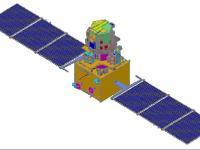
Resourcesat-2A is a remote sensing satellite intended for resource monitoring. Resourcesat-2A is a follow on mission to Resourcesat-1 and Resourcesat-2, launched in 2003 and 2011 respectively. Resourcesat-2A is intended to continue the remote sensing data services to global users provided by Resourcesat-1 and -2.
It carries three payloads which are similar to those of Resourcesat-1 and -2. They are a high resolution Linear Imaging Self Scanner (LISS-4) camera operating in three spectral bands in the Visible and Near Infrared Region (VNIR) with 5.8 m spatial resolution and steerable up to ± 26 deg across track to achieve a five day revisit capability. The second payload is the medium resolution LISS-3 camera operating in three-spectral bands in VNIR and one in Short Wave Infrared (SWIR) band with 23.5 m spatial resolution. The third payload is a coarse resolution Advanced Wide Field Sensor (AWiFS) camera operating in three spectral bands in VNIR and one band in SWIR with 56 m spatial resolution.
Resourcesat-2A carries two Solid State Recorders with a capacity of 200 Giga Bits each to store the images taken by its cameras which can be read out later to ground stations.
The satellite was successfully launched on December 07, 2016 at 10:25 hrs (IST) from SDSC SHAR, Sriharikota.

Instruments:
AWiFS (Advanced Wide-Field Sensor)
LISS-III (Linear Imaging Self-Scanning Sensor)
LISS-IV Camera

7 Dec 2016
9years
Sun synchronous
102 minutes
Linear Imaging Self Scanning Sensor
LISS III
LISS-4
LISS-III
ISRO
Natural resources management, agricultural applications, forestry, etc
No
Information about Resourcesat-2A on ISRO web page

Footer menu

  • Contact
  • Terms of Use

User account menu

  • Log in