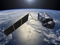
Carrying a suite of cutting-edge instruments, Sentinel-3 will measure systematically Earth’s oceans, land, ice and atmosphere to monitor and understand large-scale global dynamics. It will provide essential information in near-real time for ocean and weather forecasting. The mission is based on two identical satellites orbiting in constellation for optimum global coverage and data delivery. For example, with a swath width of 1270 km, the ocean and land colour instrument will provide global coverage every two days. Sentinel-3B was launched on 25 April 2018. With a focus towards our oceans, Sentinel-3 measures the temperature, colour and height of the sea surface as well as the thickness of sea ice. These measurements will be used, for example, to monitor changes in sea level, marine pollution and biological productivity. Over land, this innovative mission will provide a bigger picture by monitoring wildfires, mapping the way land is used, provide indices of vegetation state and measure the height of rivers and lakes – complementing the high-resolution measurements of its sister mission Sentinel-2.
Instruments: Ocean and Land Colour Instrument (OLCI) Sea and Land Surface Temperature Radiometer (SLSTR) Synthetic Aperture Aradar Altimeter (SRAL) Mircowave Radiometer (MWR) Doppler Orbitography and Radiopositioning Integrated by Satellite (DORIS)
systematic measuring of Earth’s oceans, land, ice and atmosphere to monitor and understand large-scale global dynamics; providing essential information in near-real time for ocean and weather forecasting