![]()
United
Nations
Sentinel Hub Playground (ESA, Sinergise)
| Data provided by: | Sinergise, European Space Agency (ESA) |
| Data accessibility: | Visualización de datos (ej. web SIG o monitoreo en tiempo real) |
| Link to the data: | |
| Data type: | Datos satelitales o imágenes aéreas |
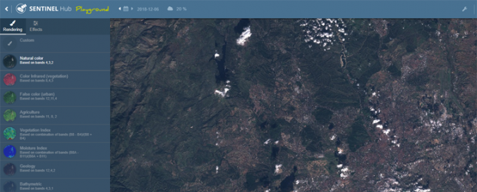
| Space-based Information: | The Sentinel Hub Playground provides a web GIS to explore satellite imagery from platorms Sentinel-2, Landsat-8 and MODIS. Sentinel and Landsat data can be displayed in a variety of predefined band combinations and spectral indices as they are generated on the fly. Costom band combination can be created by the user. Effects like atmospheric correction or color properties such as gain and gamma are adjustable. Filters allow for a selection of imagery by date of image acquisition and percent cloud cover. The Playground further includes a global digital elevation model. Downloading imagery is free but requires an EO Browser account. |
| Satellites and Sensors: | Sentinel-2A, Landsat 8, Aqua, Terra |
| Spatial coverage: | Global |
| Spatial resolution: | 10m, 20m (Sentinel-2); 30m (Landsat-8); 500m (MODIS) |
| Temporal coverage: | Archivado |
| Costs: | Gratis |
| Contact: | Sinergise |
| Tutorials on the use of data: | Sentinel Playground Introduction Video |
| Restrictions/ Citation of the dataset: |
Provider
![]()