Copernicus Emergency Management Service (CEMS) – A European Union Concrete Tool to Disaster Risk Reduction in the World
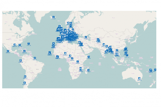
CEMS is a core service of the European Union’s Earth Observation programme Copernicus. It supports all phases of the disaster management cycle by delivering warnings and risk assessments of floods and forest fires and by providing geospatial information derived from satellite images on the impact of natural and man-made disasters all over the world (before, during or after a crisis). The two Mapping services of CEMS (Rapid Mapping, Risk and Recovery Mapping) are delivering products since April 2012. The Risk & Recovery Mapping provided for example information for preparedness, disaster risk assessment and risk reduction related to earthquakes in Nepal, several post-disaster assessments for flood and fire events, reconstruction and recovery monitoring in Haiti, and multi-risk assessments for the Azores Islands in Portugal.
CEMS is coordinated by the European Commission (joint coordination between the Directorate Generals ECHO, JRC, GROW). Activation requests are coordinated by DG ECHO’s Emergency Response and Coordination Centre (ERCC) in Brussels.
The Mapping component of the Emergency Management Service (CEMS), an operational service of the European Union’s Earth Observation programme Copernicus, provides all actors involved in the management of natural disasters, man-made emergency situations and humanitarian crises, with timely and accurate geospatial information derived from satellite remote sensing data and completed by available in situ or open data sources.
CEMS Mapping is an on-demand service which is provided in two temporal modes to support all phases of the emergency management cycle: Rapid Mapping and Risk & Recovery Mapping. It can be activated only by authorised users and is free of charge for the users. Not authorised users can submit service requests to the Emergency Response and Coordination Centre (ERCC) in Brussels.
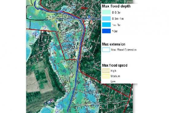
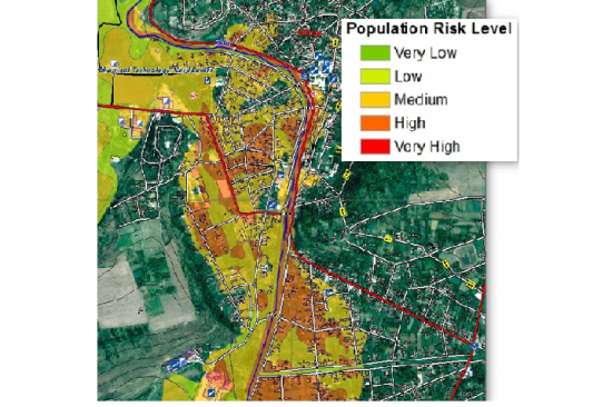
Risk & Recovery Mapping delivers maps and analyses in support of disaster risk reduction, preparedness and prevention, recovery and reconstruction, to assist disaster managers. It focuses on the pre-disaster situation when lending support to disaster prevention and preparedness actions, and on the post-disaster situation when providing support after a disaster, such as reconstruction planning and progress monitoring, and as such complements the Emergency Rapid Mapping service. Supported disaster types range from natural hazards such as floods, fires, storms, tsunamis, volcanic eruptions, landslides, and earthquakes to industrial accidents and humanitarian crises. Core datasets are satellite images and geographic information layers. In addition, a study currently looks into the use of imagery from aerial platforms (airplanes and/or drones as a complement to satellite imagery).
The service has a unique combination of global coverage, fully operational set-up, tailor-made requests, free of charge. It offers intensive detailed analysis when required.