  • English
  • Español
  • Français

United
Nations


Office for Outer Space Affairs
UN-SPIDER Knowledge Portal

  • Inicio
  • Sobre nosotros
    • Sobre ONU-SPIDER
    • Acerca de UNOOSA
    • Publicaciones
    • Ofertas de trabajo
    • Conozca el Equipo
    • Contacto
  • Aplicación Espacial
    • Guías Tecnológicas
    • Mecanismos de Emergencia
    • Mecanismos de Recuperación
    • Red Internacional de Alerta de Asteroides
    • Grupo Asesor para la Planificación de Misiones Espaciales
    • Iniciativa Internacional sobre Meteorología Espacial
    • Tecnologías Espaciales en la ONU
    • Historias de Usuarios
  • Enlaces y Recursos
    • Aplicación de datos del mes
      • Disaster Recovery
    • Fuentes de Datos
    • SIG y Software de Percepción Remota
    • Recursos de capacitación en línea
    • Instituciones
  • Riesgos y Desastres
    • Gestión del Riesgo de Desastres
    • Alerta temprana
    • Gestión de Desastres y Emergencias
    • Amenazas Naturales
    • El Proceso de la Reducción de Desastres Post-2015
    • La ONU y la Gestión del Riesgo de Desastres
    • La ONU y Alerta Temprana
    • La ONU y la Gestión de Desastres
  • Asesoría
    • Misiones de Asesoría
    • Apoyo en caso de Emergencia
    • Asesoría Virtual
    • Prácticas Recomendadas
    • Actividades de Entrenamiento
    • Usos Prácticos
  • Redes
    • Oficinas Regionales de Apoyo
    • GP-STAR
    • IN-MHEWS
    • IWG-SEM
  • Proyectos
    • SPEAR
    • FOSAT-S
    • EvIDENz
    • Flood GUIDE
  • Noticias y Eventos
    • Noticias
    • Eventos
    • Eventos pasados

Breadcrumb

  • Home
  • New Online Remote Sensing Application For Land Cover Classification And Monitoring With Landsat Data
  • New online remote sensing application for land cover classification and monitoring with Landsat data

New online remote sensing application for land cover classification and monitoring with Landsat data

Screenshot of the REMAP website. Image: REMAP.

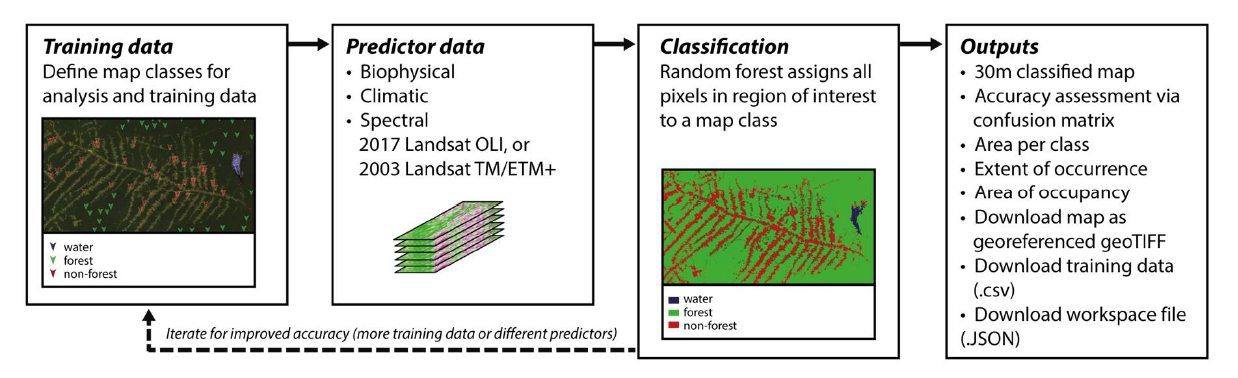
REMAP app is an open-access online application for land cover classification and monitoring. The application is aiming to extend the ability of volunteers, managers, and scientists to assess the extent of land cover changes and implement actions to help the conservation of natural environments around the world under the IUCN Red list of ecosystems.

The app utilizes geospatial data and analysis capacity of the Google Earth Engine. REMAP allows users to collectively develop classifications of land cover within an area of interest anywhere in the world where there is enough archival Landsat data. The system also facilitates monitoring and analysis of land cover change by allowing users to map ecosystem distributions at two points in time (2003 and 2017), to quantify the area of each map class and to complement a variety of other applications that support the conservation of biodiversity.

Land cover data documents how much of a region is covered by forests, wetlands, native vegetation, agriculture, and other land and water types. The capacity to measure and report change and trend in land cover over time is critical, REMAP users can evaluate as well gain insight into natural dynamic barriers condition that can protect vulnerable communities against natural hazards such as floods, hurricanes, tsunami and avalanches.

REMAP methodology
REMAP methodology

REMAP is expected to help expand the use of classified maps in ecosystem monitoring and conservation programs. Users like volunteers, students and managers will be able to determine the extent of land cover and implement conservation projects or actions to reduce the loss of natural ecosystems.

It is expected to be further developed in the future through the addition of climate maxima and minina, new global image composites, relevant and available satellite imagery, and a functionality to produce maps in mobiles devices.

Attachment Tamaño
methodology.png (291.1 KB) 291.1 KB
REMAP
Tue, 12 Dec 2017 - 11:00

Footer menu

  • Contact
  • Terms of Use

User account menu

  • Log in