![]()
United
Nations
Tremblement de terre
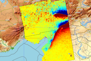
 Earth Observation Center (EOC) using data acquired by Sentinel-1A before and after the earthquake event. Image: DLR/EOC")
Definition
Facts and figures
Further information
UN-SPIDER Regional Support Offices with hazard-specific expertise
Related content on the Knowledge Portal
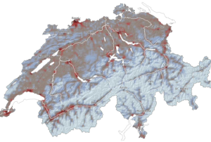
The Swiss Seismological Service (SED) at ETH Zürich introduced on March 7 the first seismic risk model for Switzerland. The new model, that complements the Seismic Hazard Map published by SED in 2004, shows the potential impact of earthquakes on the population and infrastructure in the country. The seismic risk model, that combines information about earthquake risk, effects of the local substrate, building vulnerability, and affected persons and assets, is freely available to the public. The model is intended to help government agencies make informed decisions in the face of disaster preparedness and disaster management.
Based on the seismic risk model, it is estimated that destructive earthquakes in the…
read more15/03/2023


Turkey and Syria recently experienced two devastating earthquakes of magnitude 7.8 and closely followed by a magnitude 7.5, resulting in extensive damage and destruction. The International Charter 'Space and Major Disasters' was activated by Turkish authorities, the United Nations, and the International Federation Red Cross & Red Crescent Societies in response to the earthquakes. The Charter provided more than 350 crisis images from 17 space agencies worldwide, which were used to create damage and situation maps to estimate the hazard impact and support relief actions. The Copernicus Emergency Mapping Service (CEMS), which has a cooperation agreement for sharing data and collaborating with the Charter, has also been activated. The service, which has a collaboration agreement for data sharing and working with the Charter, also employs observations from several satellites to deliver on-demand mapping.
Satellite data is proving to be invaluable for emergency aid…
read more16/02/2023
El Centro Asiático para la Reducción de Desastres (ADRC) y la Oficina de Asuntos del Espacio Ultraterrestre de las Naciones Unidas (UNOOSA) firmaron el 4 de Junio de 2009, con ocasión de la 52ª sesión de la Comisión sobre la Utilización del Espacio Ultraterrestre con Fines Pacíficos (COPUOS), el acuerdo de cooperación para el establecimiento de la Oficina Regional de Apoyo (RSO) de ADRC UN-SPIDER.
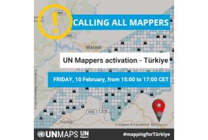
UN Mappers calls all mappers to support the Turkish Open Street Map community following the earthquake that hit southern Turkey and northern Syria on Monday 6 February.
Together with Copernicus and the International Charter activation, UN Mappers has also been activated. The community has organised a "mapathon", that will be held live on Friday 10 February from 15:00 to 17:00 CET, although mappers are invited to continue the activity over the weekend.
Click here for more information on the event. Registration is already open!
read more09/02/2023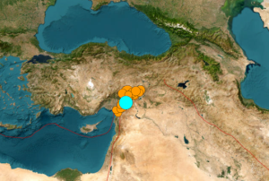
A major earthquake of magnitude 7.8 struck Turkey with epicentre on 23 kilometres east of Nurdagi (Gaziantep Province) on February 6, 2023. By the activity spreading to adjacent faults, the region was hit by a 6.7- magnitude and a 7.5- magnitude aftershocks respectively. The earthquake also affected neighbouring Syria.
The space community is also taking action through the activation of the International Charter on Space and Major Disasters. The charter provides a mechanism for the provision of satellite data to support the relief efforts of disaster-stricken areas. The Copernicus Emergency Management Service (EMS) has also been activated to provide support to the affected countries.
The use of space-based information can greatly assist in disaster response efforts. Satellites can provide detailed images and maps of the affected area to help search and rescue teams identify areas in need of assistance. They can also provide information on the extent of the damage,…
read more07/02/2023
Term Parents
UN-SPIDER Regional Support Offices with hazard-specific expertise
![]()