Flood is usually used as a general term to describe the overflow of water from a stream channel into normally dry land in the floodplain (riverine flooding), higher-than–normal levels along the coast and in lakes or reservoirs (coastal flooding) as well as ponding of water at or near the point where the rain fell (flash floods) (IRDR Glossary).
Facts and figures
Floods are the natural hazard with the highest frequency and the widest geographical distribution worldwide. According to the Organization for Economic Cooperation and Development (OECD) flooding is one of the most common, widespread and destructive natural perils, affecting approximately 250 million people worldwide and causing more than $40 billion in damage and losses on an annual basis (OECD).
Flooding occurs most commonly from heavy rainfall when natural watercourses lack the capacity to convey excess water. It can also result from other phenomena, particularly in coastal areas, by a storm surge associated with a tropical cyclone, a tsunami or a high tide. Dam failure, triggered by an earthquake, for instance, will lead to flooding of the downstream area, even in dry weather conditions.
Various climatic and non-climatic processes can result in different types of floods: riverine floods, flash floods, urban floods, glacial lake outburst floods and coastal floods.
Flood magnitude depends on precipitation intensity, volume, timing and phase, from the antecedent conditions of rivers and the drainage basins (frozen or not or saturated soil moisture or unsaturated) and status. Climatological parameters that are likely to be affected by climate change are precipitation, windstorms, storm surges and sea-level rise (UNDRR).
When floodwaters recede, affected areas are often blanketed in silt and mud. The water and landscape can be contaminated with hazardous materials such as sharp debris, pesticides, fuel, and untreated sewage. Potentially dangerous mold blooms can quickly overwhelm water-soaked structures. Residents of flooded areas can be left without power and clean drinking water, leading to outbreaks of deadly waterborne diseases like typhoid, hepatitis A, and cholera (UNDRR).
Vietnamese and American researchers joined efforts to develop a satellite-based system approach to monitor and manage transboundary flooding.
The teams from the Viet Nam National Center for Water Resources Planning and Investigation (NAWAPI) and the University of Washington co-developed and implemented an advanced water forecasting system. Recently, Viet Nam launched the satellite-based system aiming to improve timely access to upstream reservoir information in transboundary river basins of the Red and Mekong rivers. The satellite-based system provides various ways to achieve this objective.
Estimate reservoir storage and outflow
With the mass balance approach users can calculate reservoir storage and outflow with satellite data. The key inputs of the dam system are precipitation and inflow. Therefore, satellite precipitation data and hydrologic models provide…
The Tanzania Commission for Science and Technology (COSTECH), in partnership with the Revolutionary Government of Zanzibar (RGoZ), has launched an initiative to produce detailed aerial imagery maps of the islands of Zanzibar. The cooperative project is called the Zanzibar Mapping Initiative (ZMI). This initiative has drawn global attention because the mapping is done entirely with drones; the ability to map is now available widespread at a local level. The maps produced are of exceptional spatial resolution. Additionally, their free and open source data sets includes a comprehensive compilation of available vector and raster data covering the whole of Tanzania. Users can find not only aerial imagery produced from drones, but everything from census data to land use layers.
More information can be found on the ZMI project website: http://www.zanzibarmapping.com/
The MERIT DEM was developed by removing multiple error components (absolute bias, stripe noise, speckle noise, and tree height bias) from the existing spaceborne DEMs (SRTM3 v2.1 and AW3D-30m v1). It represents the terrain elevations at a 3sec resolution (~90m at the equator), and covers land areas between 90N-60S, referenced to EGM96 geoid.
Assessments of flood risk, on global to local scales, are becoming more urgent with ongoing climate change and with rapid socioeconomic developments. Such assessments need information about existing flood protection, still largely unavailable. Here we present the first open-source database of FLood PROtection Standards, FLOPROS, which enables more accurate modelling of flood risk. We also invite specialists to contribute new information to this evolving database.
The International Charter “Space and Major Disasters” has been activated for floods in Brazil following the collapse of a mining dam. The activation was requested by the Brazilian Disaster and Risk Management National Centre (CENAD). The country’s Ministry of Regional Development is acting as project manager for the activation.
A dam at an iron ore mine in the south-eastern town of Brumadinho collapsed, releasing a torrent of tailings. The large volume of sludge that spilled out of the dam then swept south west to Paraopeba River, burying the site’s cafeteria where workers were eating, as well as nearby homes and vehicles. The mud has reached a depth of 50 ft in some areas. According to media reports, 134 people were killed in the event, while another 199 are still missing.
The International Charter “Space and Major Disasters” has been activated for floods in Brazil by the Brazilian Disaster and Risk Management National Centre (CENAD). The country’s Ministry of National Integration is acting as project manager for the activation.
Mudslides and floods triggered by sudden rain over the western area of the Brazilian state of Rio Grande do Sul have caused the Ibirapuita, Ibicui and Uruguai rivers to break their banks and cause widespread flooding.
The rains have swept away entire neighbourhoods in a mountainous tourist area near RioMetSul Meteorologia reported 497mm of rainfall in 72 hours in the state of Uruguaiana.
Over 2000 people have been displaced and moved to temporary accommodation as the floods damaged houses, blocked roads and water supplies were disrupted.
Local reports say the flooding peak in the city of…
La predicción y el monitoreo del agua y el clima extremo son una parte vital de la gestión de los recursos naturales de un área. En asociación con la UNESCO, ARSET está organizando una capacitación de seis días sobre aplicaciones de percepción remota por satélite para la gestión de cuencas hidrográficas. Los asistentes aprenderán sobre técnicas de percepción remota aplicables a la gestión de recursos hídricos a través de estudios de casos y ejercicios. Los temas incluirán:
Monitoreo y predicción de desastres relacionados con el agua.
Estimaciones de precipitación
Evapotranspiración de la humedad del suelo
Radar de apertura sintética (acceso y procesamiento de datos).
, processed by ESA, CC BY-SA 3.0 IGO.")

 The Tanzania Commission for Science and Technology (COSTECH), in partnership with the Revolutionary Government of Zanzibar (RGoZ), has launched an initiative to produce detailed aerial imagery maps of the islands of Zanzibar. The cooperative project is called the Zanzibar Mapping Initiative (ZMI). This initiative has drawn global attention because the mapping is done entirely with drones; the ability to map is now available widespread at a local level. The maps produced are of exceptional spatial resolution. Additionally, their free and open source data sets includes a comprehensive compilation of available vector and raster data covering the whole of Tanzania. Users can find not only aerial imagery produced from drones, but everything from census data to land use layers.
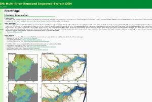 The MERIT DEM was developed by removing multiple error components (absolute bias, stripe noise, speckle noise, and tree height bias) from the existing spaceborne DEMs (SRTM3 v2.1 and AW3D-30m v1). It represents the terrain elevations at a 3sec resolution (~90m at the equator), and covers land areas between 90N-60S, referenced to EGM96 geoid.Publishing institution:
 Assessments of flood risk, on global to local scales, are becoming more urgent with ongoing climate change and with rapid socioeconomic developments. Such assessments need information about existing flood protection, still largely unavailable. Here we present the first open-source database of FLood PROtection Standards, FLOPROS, which enables more accurate modelling of flood risk. We also invite specialists to contribute new information to this evolving database.Publishing institution:
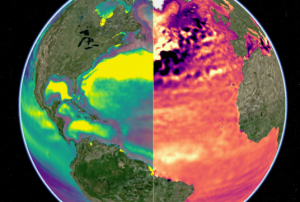
 Publishing institution:
 on Landsat 8. Image: NASA.")
 on NASA’s Terra satellite captured false-color images of the State of Rio Grande Du Sul from 2007. Image: NASA")