![]()
United
Nations
Inundación
, processed by ESA, CC BY-SA 3.0 IGO.")
Definition
Facts and figures
Further information
UN-SPIDER Regional Support Offices with hazard-specific expertise
Related content on the Knowledge Portal
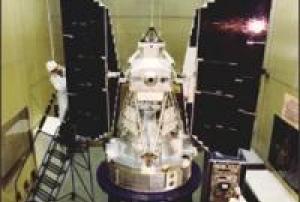
Landsat 3 was launched on March 5, 1978, three years after Landsat 2.
read more
The Landsat program’s technical and scientific success together with political and economic pressures lead to the decision to commercialize an operational Landsat. To this end, responsibility was slated to shift from NASA (a research and development agency) to the National Oceanic and Atmospheric Administration (NOAA), the agency charged with operating the weather satellites. This was done via Presidential Directive/NSC-54 signed on Nov. 16, 1979 which assigned NOAA “management responsibility for civil operational land remote sensing activites.” (However, operational management was not transfered from NASA to NOAA until 1983).
Landsat 3 carried the same sensors as its predecessor: the Return Beam Vidicon (RBV) and the Multispectral Scanner (MSS). The RBV instrument on-board Landsat 3 had...05/03/1978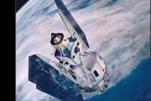
Landsat 2 was launched into space onboard a Delta 2910 rocket from Vandenberg Air Force Base, California on January 22, 1975, two and a half years after Landsat 1. Originally named ERTS-B (Earth Resource Technology Satellite B), the spacecraft was renamed Landsat 2 prior to launch. The second Landsat was still considered an experimental project and was operated by NASA.
Landsat 2 carried the same sensors as its predecessor: the Return Beam Vidicon (RBV) and the Multispectral Scanner System (MSS).
On February 25, 1982 after seven years of service, Landsat 2 was removed from operations due to yaw control problems; it was offically decommissioned on July 27, 1983.Instruments:
read more
Return Beam Vidicon (RBV)
Multispectral Scanner (MSS)
22/01/1975
Landsat 1 was launched on July 23, 1972; at that time the satellite was known as the Earth Resources Technology Satellite (ERTS). It was the first Earth-observing satellite to be launched with the express intent to study and monitor our planet’s landmasses. To perform the monitoring, Landsat 1 carried two instruments: a camera system built by the Radio Corporation of America (RCA) called the Return Beam Vidicon (RBV), and the Multispectral Scanner (MSS) built by the Hughes Aircraft Company. The RBV was supposed to be the prime instrument, but the MSS data were found to be superior. In addition, the RBV instrument was the source of an electrical transient that caused the satellite to briefly lose altitude control, according to the Landsat 1 Program Manager, Stan Weiland.
read more
To help understand the data and to explore the potential applications of this new technology, NASA oversaw 300 private research investigators. Nearly one third of these were international scientists...23/07/1972
NASA's Applied Remote Sensing Training Program is organizing an online instructor-led training event focusing on the challenges of mapping and risk assessments conducted in regugee camps along with other displaced populations. This training will cover issues related to flood risk, decision making challenegs involving long term heat stress, and monitoring drought impacts on agricutlural landscapes examined through Earth observations. At its conclusion, participants will be able to integrate EO, building footprint and infrastructure data, and population data to quantify climate risk and development trends in specific humanitarian settings, and recognize the value and limitations of specific EO and geospatial datasets.

The Copernicus Climate Change Service (C3S), along with the World Meteorological Organization (WMO) have recently released their 2023 European State of the Climate report (ESOTC 2023), which included a number of key findings in regards to the climatological conditions around Europe, including and overview of the extensive flooding and temperature conditions around the region.
Along with a variety of maps detailing the differential coverage and intensity of these conditions, they have found that the temperatures in Europe were above average for 11 months of the year, and a third of the river networks exceeded the ‘high’ flood threshold (with 16% reaching the ‘severe’ flood threshold).
In a press release containing an overview of the report, the organizations discussed a number of topics including the general trend of climate change and warming temperatures, the subsequent health impacts these may have on the people in Europe, a brief discussion on the seasonal...
read more06/05/2024 The Copernicus Coastal Hub offers free and openly accessible geospatial information for download regarding subject that impact coastal regions around the world.Publishing institution:
Scientists at the University of Glasgow have pioneered a method for monitoring river flows using satellite analysis, offering an advanced early warning system for flood risk. Current methods rely on expensive and challenging-to-install stream gauges, limiting coverage, especially in remote areas. The Glasgow researchers utilized video footage from a Chinese satellite to measure river discharge during a February 2022 flood along a 12-mile section of Australia's Darling River. By tracking visible surface features in the footage and combining it with detailed elevation maps, they achieved flow discharge estimates within 15% of measurements from traditional gauges. The technology, providing real-time insights and overcoming limitations like cloud cover, could significantly improve flood prediction and response worldwide, benefiting communities facing increasing climate change-induced weather unpredictability.
The team’s paper, titled ‘...
read more17/01/2024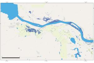
Over 4,000 residents in Ghana's south eastern region have been forced to abandon their homes due to widespread flooding. The crisis has been triggered by the overflowing of the Akosombo Dam, resulting in the devastating destruction of homes and farmlands along the banks of the River Volta.
The deluge has led to the disruption of essential services, leaving some areas without access to water and electricity. Ghana's Volta River Authority had previously asked residents to move to higher ground as water levels upstream of the dam continued to rise due to heavy rains.
UNOOSA/UN-SPIDER requested the activation of the International Charter Space and Major Disasters on behalf of the National Disaster Management Organization (NADMO) of Ghana and served as a Valued Added Provider. As Project Manager the National Space Research and Development Agency (NASRDA) of Nigeria, a UN-SPIDER Regional Support Office, was nominated.
... read more
Floods, triggered by intense rainfall, affect many communities worldwide. The extremely large floods in Pakistan in 2022, as well as other very large floods in Nigeria, Mozambique, and other countries, impacted many communities, affected their livelihoods, and triggered major losses. According to the Intergovernmental Panel on Climate Change (IPCC), climate change will lead to increased precipitation in many regions, worsening the impacts of floods triggered by such precipitation. Ways in which communities lessen the impact of floods include the implementation of flood risk reduction measures such as land-use ordinances minimizing the exposure of vulnerable elements including infrastructure to floods, and the routine operation of flood early warning systems.
To contribute to improve flood early warning systems, the European Commission and the European Centre for Medium-Range Weather Forecasts (ECMWF) launched the Global Flood Awareness System (GloFAS) in the Spring of...
read more29/08/2023.")
Heavy rainfall triggered severe floods in the Southern region of Mozambique, including areas of Maputo. The National Disaster Risk Management Institute (INGC) reported around 37,000 people affected, and contacted UN-SPIDER. At the request of INGC, UN-SPIDER activated the International Charter Space and Major Disasters. The International Charter was activated on 16 February 2023, designating the International Water Management Institute as project manager and INGC as a value-added provider.
More information on this activation of the International Charter is available here.
More information on these floods from reliefweb is available here.
More information on the activation of the Copernicus Emergency Management Service - Mapping is available...
read more
Term Parents
UN-SPIDER Regional Support Offices with hazard-specific expertise
![]()