![]()
United
Nations
Deslizamiento de tierra

Definition
Facts and figures
Further information
UN-SPIDER Regional Support Offices with hazard-specific expertise
Related content on the Knowledge Portal
 Publishing institution:
- Fifth World Landslide Forum - Implementing and Monitoring the ISDR-ICL Sendai Partnerships 2015-2025

The International Consortium on Landslides (ICL) and the ISDR-ICL Sendai Partnerships 2015-2025 announce the 5th World Landslide Forum (WLF5) to be held November 2-6, 2020, in Kyoto Japan.
This Forum will include a mid-term review of the ISDR-ICL Sendai Partnerships, voluntary contribution to the Sendai Framework 2015-2030 and the Agenda 2030 – Sustainable Development Goals, especially Goal 11 "Make cities and human settlements inclusive, safe, resilient and sustainable".
Participants of the Fourth World Landslide Forum adopted the ...
read more 
This webinar focuses on Flood History and - Risk as well as on Land Motion (subsidence), but related topics that will be touched upon are LU/LC and Change, Transport Infrastructure and Green Urban areas, as these are also relevant for assessing sustainability of cities with respect to Climate Resilience and Disaster Management. During the webinar use cases and applications of EO based solutions are demonstrated for several cities.
") The European Soil Data Centre (ESDAC) has provided a map with soil assessments from the years 2001 and 2012.
The European Soil Data Centre (ESDAC) has provided a map with soil assessments from the years 2001 and 2012.
Five years ago, the National Aeronautics and Space Administration (NASA) and the Japan Aerospace Exploration Agency (JAXA) launched the Global Precipitation Measurement (GPM) Core Observatory as a joint satellite. Since then, the instruments on GPM have provided advanced measurements about rain and snow particles within clouds, Earth’s precipitation patterns, extreme weather and precipitation that affects communities around the world.
GPM was engineered to get data to scientists, operational and application users as soon as possible for societal benefits. It obtains data quickly using the Tracking and Data Relay Satellite (TDRS) 12-member satellite constellation, which serves as an information pipeline between Earth-orbiting satellites and NASA ground stations. On average, GPM can take one to three hours to get data into users’ hands, but in emergencies, the average delivery time can be shortened to between 15 and 90 minutes.
GPM’s main...
read more02/04/2019
The training date is in the past. However, videos and resources of the training can be accessed here.
According to the WHO, every year disasters “kill around 90,000 people and affect close to 160 million people worldwide.” This training will show participants how NASA remote sensing data can be used to characterize and monitor disaster-related events and support relief efforts. Each session will cover a different disaster and its supporting data. Disaster scenarios include tropical storms, flooding, earthquakes, and landslides.
Learning Objectives
By the end of this training, attendees will be able to:
-
Identify NASA data products to characterize and monitor the disasters, Tropical Storms, Flooding, Landslides and...
-
 to the plains in the south (right side). Vegetation appears red in this false-colour image, while waterways and buildings appear light green and blue. Image: ESA.")
On 12 March, Nepal Telecommunications Authority (NTA) signed an agreement with French satellite operator Thales Alenia Space to build Nepal’s first communications satellite. The Nepalese government intends to use the satellite to provide nationwide internet access to its citizens, improve disaster management efforts and strengthen economic growth in the country.
The development of Nepal’s own satellite system proves to be significant in terms of improving the country’s disaster management efforts. Nepal is regularly faces natural disasters such as droughts, floods, landslides, fires, and...
read more29/03/2019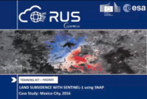
This webinar aims to show how to use SAR interferometry (InSAR) to identify and map land subsidence using the ESA SNAP Sentinel-1 Toolbox. It demonstrate how to access the RUS Service and how to download, process, analyze and visualize the free data acquired by the Copernicus satellites.
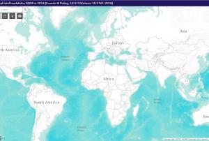 The Global Fatal Landslide Database (GFLD) has been consistently collected and maintained since 2004. Systematic metadata search tools based in the English language are used to identify relevant reports of landslide activity. Reports are corroborated and data updated by source triangulation using government and aid agency reports, academic papers and personal communications as new information becomes available. This version of the dataset contains all non-seismically triggered fatal landslide events from 2004 to 2016. A web platform is currently under development to host the full database openly and provide users with more functionality, including data download and crowd source reporting.Publishing institution:
While several studies have already highlighted how global warming and its consequences are predicted to increase the frequency and magnitude of geohazards such as landslides, the relation between ongoing climate shifts and landslide behaviour is still difficult to assess, especially due to uncertainties in both models. In a new research paper, researchers at NASA's Jet Propulsion Laboratory and collaborating institutions have now documented the transition of a stable, slow-moving landslide into catastrophic collapse for the first time.
Their observations lasted eight years and took place on the California Coast Ranges, which, due to their morphological structure, are an ideal natural laboratory to investigate how stress and fluid pressure changes govern the stable and unstable sliding of landslides. In recent years, more than 650 slow-moving landslides have been identified and mapped in the area. Yet, on May 20, 2017, the Mud Creek landslide...
read more20/02/2019
Term Parents
UN-SPIDER Regional Support Offices with hazard-specific expertise
![]()