![]()
United
Nations
Sequía
 instrument aboard ESA’s Envisat satellite. Image: ESA, CC BY-SA 3.0 IGO.")
Definition
Facts and figures
Further information
UN-SPIDER Regional Support Offices with hazard-specific expertise
Related content on the Knowledge Portal
 ,
, 
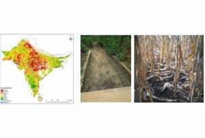
IDSI integrates multi-source remote sensing data from moderate resolution imaging spectroradiometer (MODIS) and tropical rainfall measuring mission (TRMM), ESA Soil Moisture (ASCAT) Products and it synthesizes precipitation deficits, soil thermal stress and vegetation growth status in drought process. Therefore, this method is favourable to monitor the comprehensive drought over South Asia.
Publishing institution: ,
,  ,
,  ,
, 
Intensive capacity development sessions for Pacific island countries (Cook Islands, Fiji, Kiribati, Micronesia (the Federated States of), Samoa, Solomon Islands, Tonga, and Vanuatu).
The project aims to enhance institutional and technical capacity for using geospatial data and technology applications and promote regional cooperation for sharing geospatial data for disaster management in Pacific island countries.
read morePublishing institution: ,
, 
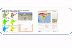
Persistent and prolonged droughts in Cambodia are severely affecting agricultural production, specifically for rice. Cambodia is moving towards improving drought management through ESCAP’s Regional Drought Mechanism. Supported by China, a tailored drought monitoring system is being established through DroughtWatch at different scales using different earth observation data. The Government of Australia is working towards building a water accounting system for Cambodia, using its innovative tool Source. In addition, Australia, with support from Thailand, is also working towards supporting both of these tools by establishing a pilot DataCube for Cambodia to improve storage of pre-processed Earth observation data. Working with institutes such as the Regional Integrated Multi-Hazard Early Warning System for Africa and Asia (RIMES), information can be shared before the start of the growing season through their Monsoon Forums. Additional partners, such as UNOSAT, are supporting...
read morePublishing institution: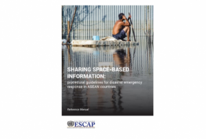 ,
,  ,
,  ,
, 
Developed for the needs of the ASEAN sub-region in Asia and the Pacific, the handbooks can also be adapted for use in other regions.
The handbooks have been developed through expert working groups, in collaboration with United Nations partners including UNOOSA/UN-SPIDER, UNITAR-UNOSAT, and OCHA. As well as extensive consultation with space agencies, national disaster management authorities and regional institutions, including GISTDA, LAPAN, ASEAN Coordinating Centre for Humanitarian Assistance on Disaster Management and Asian Institute of Technology.
read morePublishing institution: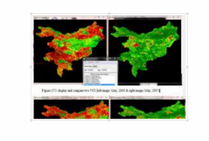 ,
, 
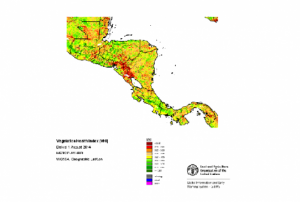
Vegetation Condition Index according to Kogan et al. (1990). Two-weeks normalized Differenced Vegetation Index (NDVI) composites based on 250m MODIS data are freely available for download from the MODIS/NDVI Time Series Database from the Global Agriculture Monitoring (GLAM) Project provided via the website of Geographic Department of Maryland University.
Publishing institution:- Publishing institution:
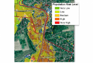
 of 2.7 m (i.e., less than one floor) and the share of built-up area could be estimated with a MAE of 13.3 %, when compared to a reference data set.")
Mapping of built-up height and share of built-up area for the example of the city of Munich. The estimated average built-up height features a mean absolute error (MAE) of 2.7 m (i.e., less than one floor) and the share of built-up area could be estimated with an MAE of 13.3 %, when compared to a reference data set.
Publishing institution:") ,
, ") ,
, ")
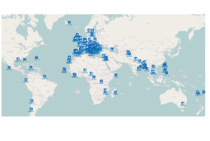
For a comprehensive and objective analysis of the settlement patterns, the DLR additionally developed an approach to display the spatial networks between the mapped settlements. It enables the computation of various form and centrality measures to characterize settlement patterns, at different spatial units, ranging from global to local scale.
read morePublishing institution: during the second dekad of February 2017") ,
,  ,
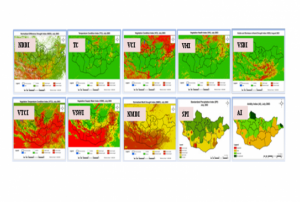
,  occurred during the crop cycle at pixel level. The second step would be the calculation of the percentage of agricultural area affected by drought (pixels with VHI<35) on this way assessing the extent of the drought. Finally the whole administrative area will be classified according to the percentage of area affected.") ,
, 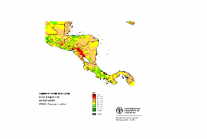
The Agricultural Stress Index System (ASIS) is based on 10-day (dekadal) satellite data, of vegetation and land surface temperatures, from the METOP-AVHRR sensor at 1 km resolution. Data for Country-level ASIS is freely available for download from FAO FTP. Time Series Database from 1984.
read morePublishing institution: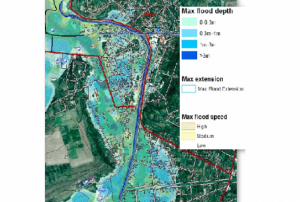 ,
,  ,
, 
CEMS is a core service of the European Union’s Earth Observation programme Copernicus. It supports all phases of the disaster management cycle by delivering warnings and risk assessments of floods and forest fires and by providing geospatial information derived from satellite images on the impact of natural and man-made disasters all over the world (before, during or after a crisis). The two Mapping services of CEMS (Rapid Mapping, Risk and Recovery Mapping) are delivering products since April 2012. The Risk & Recovery Mapping provided for example information for preparedness, disaster risk assessment and risk reduction related to earthquakes in Nepal, several post-disaster assessments for flood and fire events, reconstruction and recovery monitoring in Haiti, and multi-risk assessments for the Azores Islands in Portugal.
CEMS is coordinated by the European Commission (joint coordination between the Directorate Generals ECHO, JRC, GROW). Activation requests...
read morePublishing institution:
Term Parents
UN-SPIDER Regional Support Offices with hazard-specific expertise
![]()