![]()
United
Nations
Desplazamiento de masas
 on top of a mountain. It then pushed mud down across the city of Mocoa (green) and crossed the nearby river. The Sentinel-1-derived data product (from scans on 20 March and 1 April) has been overlaid onto a Sentinel-1 radar image. Image: Modified Copernicus")
Definition
Facts and figures
Further information
UN-SPIDER Regional Support Offices with hazard-specific expertise
Related content on the Knowledge Portal
 or when the total rainfall exceeds 100 mm. The new system can analyze the amount of accumulated rainfall, which is important for landslide disaster prevention") ,
, .") ,
, .")
Many of the sediment disasters were likely generated by the heavy rain. Sediment danger is alerted to during heavy rainfalls (≥20 mm/h), or when the total rainfall exceeds 100 mm. The new system can analyse the amount of accumulated rainfall, which is important for landslide disaster prevention.
read morePublishing institution:") ,
, ") ,
, ")
For a comprehensive and objective analysis of the settlement patterns, the DLR additionally developed an approach to display the spatial networks between the mapped settlements. It enables the computation of various form and centrality measures to characterize settlement patterns, at different spatial units, ranging from global to local scale.
read morePublishing institution: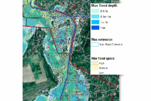 ,
,  ,
, 
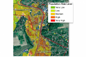
CEMS is a core service of the European Union’s Earth Observation programme Copernicus. It supports all phases of the disaster management cycle by delivering warnings and risk assessments of floods and forest fires and by providing geospatial information derived from satellite images on the impact of natural and man-made disasters all over the world (before, during or after a crisis). The two Mapping services of CEMS (Rapid Mapping, Risk and Recovery Mapping) are delivering products since April 2012. The Risk & Recovery Mapping provided for example information for preparedness, disaster risk assessment and risk reduction related to earthquakes in Nepal, several post-disaster assessments for flood and fire events, reconstruction and recovery monitoring in Haiti, and multi-risk assessments for the Azores Islands in Portugal.
CEMS is coordinated by the European Commission (joint coordination between the Directorate Generals ECHO, JRC, GROW). Activation requests...
read morePublishing institution:
 Publishing institution:
 mPublishing institution:
-
mPublishing institution:
 Publishing institution:
Term Parents
UN-SPIDER Regional Support Offices with hazard-specific expertise
![]()