Floods - Online Training on Copernicus Data and Theoretical Background
This is event is available for participation on an ongoing basis
nuria.alonso Mon, 19 Jun 2023 - 13:25

Floods are some of the most frequent natural disasters that can become a major threat to livelihoods, food-security, infrastructure and even life. Remote sensing and earth observation provide valuable tools to monitor ongoing floods and drought, assess the current situation from space and produce products that can support stakeholders and decision makers. 

0
0
The training is specifically meant for participants from African countries from government agencies, academia, NGOs or other institutions involved in disaster management or risk reduction. 
No certificate issued or not known
0.00
USD
07/04/2023, 12:00am
not visible

Center for Remote Sensing of Land Surfaces (ZFL) of the University of Bonn

1

UNOSAT and the Rwanda Space Agency Forge Collaboration in Geo-Information Technologies for Sustainable Development

The United Nations Satellite Centre (UNOSAT) and the Rwanda Space Agency (RSA) finalised a framework cooperation agreement to leverage geo-information technologies for sustainable development. Under the agreement, UNOSAT and the RSA will join efforts in utilising satellite imagery and geospatial data for various purposes, amongst which disaster management, environmental monitoring, urban planning, and sustainable development initiatives.

MOOC on Drought Assessment and Monitoring from Space

This is event is available for participation on an ongoing basis

The MOOC on Drought Assessment and Monitoring from Space (2nd version) has been launched by the EO Africa R&D Facility and will be available online until the end of February 2024.

0
0
Certificate issued

Registration in the EO AFRICA Community is required for this MOOC.

0.00
USD
05/03/2023, 12:00am - 01/28/2024, 12:00am
not visible

Monitoring Water Quality of Inland Lakes using Remote Sensing

This is event is available for participation on an ongoing basis

This advanced-level training will focus on using remote sensing observations from Landsat 8 and 9, Sentinel-2, and Sentinel-3 for assessing water quality parameters, including chlorophyll-a concentration, turbidity, and Total Suspended Solids (TSS) in inland lakes. This training will also highlight the importance of in situ measurements of these parameters, coincident with satellite observations, in developing methodologies for operational water quality monitoring.

0
0
No certificate issued or not known
0.00
USD
07/18/2023, 12:00am - 07/25/2023, 12:00am
not visible
1
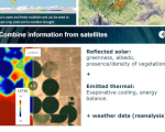
Surface Soil Moisture Products at Continental Scale
This is event is available for participation on an ongoing basis
nuria.alonso Tue, 6 Jun 2023 - 10:01

The EO Africa Research & Development Facility is organising the webinar "Surface Soil Moisture products at continental scale", executed by TU Wien, on June 13 at 14:00 CET. 

0
0
No certificate issued or not known
0.00
USD
06/13/2023, 12:00am
not visible

5th International Disaster & Resilience Congress (idRc2023)

This is event is available for participation on an ongoing basis

The 5th International Disaster & Resilience Congress, or idRc2023, will be held on a hybrid format on October 11-13. The congress, organized by the Disaster and Emergency Management Presidency (AFAD), the Gebze Technical University and the Ministry of the Interior, will have the theme of “Disaster Resilient Türkiye”.

0
0
No certificate issued or not known
0.00
USD
10/11/2023, 12:00am - 10/13/2023, 12:00am
Visible
Gebze Technical University
Gebze
1

NASA Researchers Test Novel Approach to Detect Tsunamis using GPS signals

Scientists at the U.S. National Aeronautics and Space Administration (NASA) are testing a novel approach to detect tsunamis by the rumble they make in the atmosphere.The new hazard-monitoring technology, called GUARDIAN (GNSS Upper Atmospheric Real-time Disaster Information and Alert Network), uses GPS signals to go wave-hunting in the Pacific Ring of Fire.

UNOOSA Published Annual Report 2022

UNOOSA's Annual Reports describe the Office's work in promoting international cooperation for the peaceful use and exploration of space, and in the use of space science and technology for sustainable economic and social development. They also illustrate statistics and provide key facts about UNOOSA.

The Annual Reports function not only as an activities report to the members of the United Nations Committee on the Peaceful Uses of Outer Space, but also as an awareness-raising tool for UN member states and the public.