![]()
United
Nations
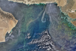
Efflorescences algales nuisibles
, processed by ESA, CC BY-SA 3.0 IGO.")
Definition
Facts and figures
Further information
UN-SPIDER Regional Support Offices with hazard-specific expertise
Related content on the Knowledge Portal
") ,
, ") ,
, ")
For a comprehensive and objective analysis of the settlement patterns, the DLR additionally developed an approach to display the spatial networks between the mapped settlements. It enables the computation of various form and centrality measures to characterize settlement patterns, at different spatial units, ranging from global to local scale.
read morePublishing institution: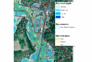 ,
,  ,
, 
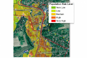
CEMS is a core service of the European Union’s Earth Observation programme Copernicus. It supports all phases of the disaster management cycle by delivering warnings and risk assessments of floods and forest fires and by providing geospatial information derived from satellite images on the impact of natural and man-made disasters all over the world (before, during or after a crisis). The two Mapping services of CEMS (Rapid Mapping, Risk and Recovery Mapping) are delivering products since April 2012. The Risk & Recovery Mapping provided for example information for preparedness, disaster risk assessment and risk reduction related to earthquakes in Nepal, several post-disaster assessments for flood and fire events, reconstruction and recovery monitoring in Haiti, and multi-risk assessments for the Azores Islands in Portugal.
CEMS is coordinated by the European Commission (joint coordination between the Directorate Generals ECHO, JRC, GROW). Activation requests…
read morePublishing institution:
Polluted water influences all aspects of life, including people, animals, and the environment. NASA satellite observations provide near real-time information about water quality. This freely available data can help decision-makers in their work. Satellite data can have applications for managing drinking water, public health, and fisheries.
This webinar series will help attendees perform advanced image processing of satellite data. Attendees will also learn about using satellites to track indicators of harmful algal blooms. This will include monitoring water temperature and chlorophyll-a concentrations. Attendees can also use this information for reporting around UN SDG 6.

-
Term Parents
UN-SPIDER Regional Support Offices with hazard-specific expertise
![]()