![]()
United
Nations
Deslizamiento de tierra

Definition
Facts and figures
Further information
UN-SPIDER Regional Support Offices with hazard-specific expertise
Related content on the Knowledge Portal
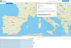 ESA's Earth Observation Thematic Exploitation Platform (TEP) is a browser for satellite imagery and specific products on an environmental topic. The TEP platforms are divided into 7 categories: Coastal; Forstry; Geohazards; Hydrology; Polar; Urban; and Food Security. Each platform is a collaborative, virtual work environment providing access to EO data and the tools, processors and Information and Communication Technology resources required to work with them. TEP aims to bridge the gap between the users and the data and tools.Publishing institution:
The National Aeronautics and Space Administration (NASA) of the United States is currently building a worldwide database of landslide events. The Cooperative Open Online Landslide Repository (COOLR) includes NASA’s Global Landslide Catalog (GLC) which provides new insights into landslide hazards around the world.
The COOLR project is an open platform where scientists and citizen scientists around the world can share landslide reports to guide awareness of landslide hazards for improving scientific modelling and emergency response.
Landslides cause billions of dollars in infrastructural damage and thousands of deaths every year around the world. However, although data on past landslide events guides future disaster prevention, a global picture of exactly where and when landslides occur does still not exist.
There are three main reasons why it is difficult to monitor landslides globally. First, landslides often occur...
read more07/06/2018


-
The Space and Upper Atmosphere Research Commission (SUPARCO) of Pakistan and the United Nations Office of Outer space Affairs (UNOOSA) signed the cooperation agreement on the establishment of a UN-SPIDER Regional Support Office (RSO) on the occasion of the 47th Scientific and Technical Subcommittee sessions on 12 February 2010.
SUPARCO, the national space agency, was established in 1961 as a Committee and was granted the status of a Commission in 1981. SUPARCO is mandated to conduct R&D in space science, space technology, and their peaceful applications in the country. It works towards developing indigenous capabilities in space technology and promoting space applications for socio-economic uplift of the country.
Address:
Pakistan Space and Upper Atmosphere Research Commission (SUPARCO)
Islamabad Highway,
Islamabad-44000 PakistanMission/Objective:
To...
read more
Term Parents
UN-SPIDER Regional Support Offices with hazard-specific expertise
![]()