The UN-SPIDER Network and its activities
The UN-SPIDER Network and its activities
Activities of the United Nations Platform for Space-based Information for Disaster Management and Emergency Support (UN-SPIDER) Regional Support Office in Nigeria for 2009/2010
Activities of the United Nations Platform for Space-based Information for Disaster Management and Emergency Support (UN-SPIDER) Regional Support Office in Nigeria for 2009/2010
Godstime K. James and Halilu A. Shaba, UN-SPIDER Regional Support Office in Nigeria, Space Applications Department, National Space Research and Development Agency, Abuja, Nigeria.
Introduction
Disasters have been around for a while, dating back to the early human civilization. According to Niekerk (2007), some of the earliest contributions to the field of disaster science were from Carr (1932), Sorokin (1942), Eldenman (1952), Quarantelli (1954 and 1957), Moore (1956), Fritz and Williams (1957), Drabek and Quarantelli (1967), Doughty (1971), Hewitt and Burton (1971), Kreps (1973), Westgate and O'Keefe (1976), Jager (1977), Torry (1978), and Turner (1978). Today, natural and human induced disasters have continued to claim lives and properties in different parts of the world. While naturally induced disasters such as earthquakes, tsunamis, hurricanes, and landslides are driven by natural processes, human induced disasters such as oil spills, air pollution, chemical and biological disasters are caused by anthropogenic activities.
It is of course possible to manage disasters by (i) minimizing potential risks through the development of disaster early warning strategies, (ii) preparing developmental plans to provide resilience to such disasters, (iii) mobilizing resources including communication and e-health services and (iv) helping in rehabilitation and post-disaster reconstruction (Jayaraman et al., 1997). In addition, studies have shown that natural and human induced disasters transcend geographic boundaries. For example, the 2004 Tsunami in South-East Asia affected Indonesia, India, Malaysia, Myanmar, Sri Lanka, Somalia, and Thailand. Furthermore, the effects of disasters are more pronounced among the poor in developing countries. 94.25% of all people killed by disasters from 1975 to 2000 were low income or lower-middle income earners (Briceño, 2008). Consequently, in its resolution 61/110 in 2006, the United Nations General Assembly decided to establish the programme “Platform for Space-based Information for Disaster Management and Emergency Response” (UN-SPIDER), to provide universal access to all countries (especially developing countries) and relevant international and regional organizations to space-based information and services relevant to the full disaster management cycle.
The Regional Support Office in Nigeria
The UN-SPIDER Regional Support Offices (RSO) constitute one of the organizational frameworks for the implementation of UN-SPIDER activities. One of the reasons for adopting a regional organizational framework is to harness regional strengths in space based disaster management and emergency response. The UN-SPIDER Regional Support Office in Nigeria is hosted in the National Space Research and Development Agency (NASRDA), Abuja, Nigeria. It was established in 2008 through an agreement between NASRDA (Nigeria) and the United Nations Office for Outer Space Affairs (UNOOSA)
Activities of the Regional Support Office in Nigeria in 2009
The activities of the RSO for 2009 were focused on the implementation of the work plan approved by the United Nations General Assembly for the biennium 2008-2009 (A/AC.105/929). They include: systematic compilation of all available relevant information; ensuring that relevant information is easily accessible and disseminated to all interested end-users; awareness-raising; outreach activities; support to national activities; support to the establishment of national disaster management planning and policies; and support to capacity-building.
Ensuring that relevant information is easily accessible and disseminated to all interested end-users
One of the fastest means of information accessibility and dissemination is through the web. As a result, the RSO developed a web portal for information dissemination (www.unspider-ng.net). The web contents include: functions and goals of the RSO; contact details for staffs of the RSO; links to other UN-SPIDER websites; information on upcoming UN-SPIDER events; provisions for building community of practice using blogging mechanism; links to capacity development sites for capacity development in space technology in Africa; links to relevant stakeholders in disaster management and emergency response in Africa.
Awareness-Raising
The successful implementation of the UN-SPIDER programme is based on the successful creation of programme awareness. The goal of the awareness-raising efforts is two-folds; first, to educate disaster managers on the role of space technology in the management of the entire disaster cycle, and second, to show the various sources of such space-based technology. Consequently, the RSO participated in the workshop for ECOWAS disaster risk reduction working group organized by the ECOWAS commission in Abuja from March 18th to 19th 2009. During the workshop, the RSO representative (Dr. Godstime James) met with the representatives from the disaster risk reduction offices in Ghana, Togo, Senegal, Cote d’Ivoire and Cape Verde. The representatives were briefed on the activities of the RSO (Figure 1). One of the spin-offs from the awareness campaign was the invitation from the Government of Togo to UN-SPIDER for a Technical Advisory Mission (TAM).
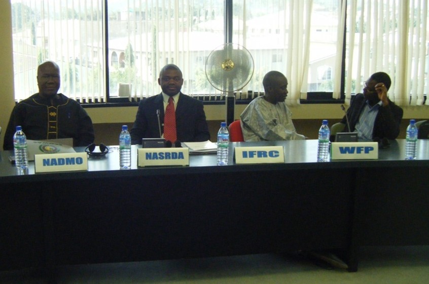
Figure 1. (L-R). Mr. Ebenezer Portuphy (National Coordinator, NADMO, Ghana), Dr. Godstime James (Manager, UN-SPIDER, NASRDA), Mr. Amadou Ndiaye (Programme Coordinator, National RRC, Senegal), and Mr. Hounkpe Koffi (Focal Point for DRR Togo) during the ECOWAS DRR meeting in Abuja.
Outreach Activities
An outreach activity is the platform within which the UN-SPIDER programme facilitates the participation of disaster managers and space-based information service providers in the activities of UN-SPIDER or its affiliates. As a result, within the framework of the outreach activities, the RSO was involved in the following outreach programmes:
Development of MOU with ECOWAS
The Economic Community for West African States (ECOWAS) plays a major role as a link to West African countries for disaster risk reduction and management. In recognition of the contribution of the RSO to disaster management within the ECOWAS sub-region, representatives of the ECOWAS commission, Abuja, visited the RSO on the 25th of February 2009. The visitors initiated the development of a Memorandum of Understanding (MOU) between NASRDA and ECOWAS to facilitate joint outreach activities in disaster management within the region. A draft of the MOU has been prepared by NASRDA, vetted by the legal department of NASRDA and sent to ECOWAS for inputs. The final version of the MOU will be signed by the Director General/Chief Executive of NASRDA and the President of the ECOWAS commission in Abuja.
Participation in UN-SPIDER workshops and meetings
For proper coordination of UN-SPIDER activities in the regional support offices, the UN-SPIDER staff in Vienna and Bonn organizes a series of meetings and workshops. The RSO participated in the “UN-SPIDER Stakeholders Meeting”, held in Vienna from 10th to 11th February 2009 (Figure 2).
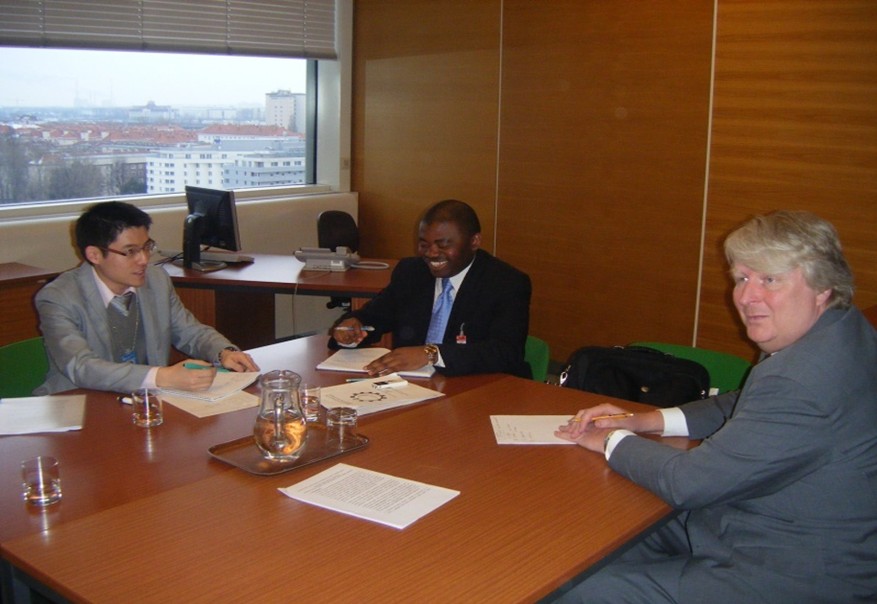
Figure 2. (L-R). Mr. Tony Young Lyu (UN-SPIDER-Vienna), Dr. Godstime James, (Manager, RSO-Nigeria), and Mr. David Stevens (Coordinator, UN-SPIDER-Vienna) during the presentation of the 2009 RSO-Nigeria activities in Vienna.
Similarly, the RSO participated in the Third United Nations International UN-SPIDER Bonn Workshop titled "Disaster Management and Space Technology - Bridging the Gap", held in Bonn, Germany from 21st to 23rd of October 2009. During the workshop, the RSO representative presented a paper documenting the role of Telemedicine in Disaster Management in Nigeria.
Participation in the International Charter: Space and Major Disasters Authorised User Training
One of the sources of satellite data for disaster management and emergency response is the International Charter: Space and Major Disasters (Charter). The goal of the Charter is to provide a unified system of space data acquisition and delivery to those affected by natural or man-made disasters through Authorized Users. Consequently, the Charter Authorised User Training was organized by the Disaster Monitoring Constellation international imaging (DMCii), Limited in collaboration with the Nigerian National Emergency Management Agency (NEMA) in Abuja. The RSO (represented by Mr. Zubair Opeyemi) participated in the workshop from the 25th to 26th of March, 2009.
Support to National Activities
The National Focal Point (NFP) is the primary contact of the UN-SPIDER Programme. An NFP is a national institution, nominated by the Government of the respective country, representing the disaster management and space application communities (A/AC.105/929). The primary role of NFPs is to work with UN-SPIDER to strengthen national disaster management planning and policies and implement specific national activities that incorporate space-based technology solutions in support of disaster management and emergency response. One of the efforts by the RSO to promote the establishment of NFPs has been to reach out to the countries in the West African region and encourage them to consider identifying an NFP in their country. For example, the National Emergency Management Agency in Nigeria was encouraged to become an NFP for Nigeria. Similarly, Togo and Cameroon were encouraged to also nominate one.
Capacity Building
Capacity development is a major requirement for the optimum utilization of space-based information for disaster management and emergency response. Similarly, the acquisition, processing and transfer of knowledge in space applications for disaster management is essential for the success of UN-SPIDER. Hence, the RSO is currently compiling available resources for capacity development in space applications for disaster management. This is an ongoing process and a list of relevant training institutions are posted on the RSO website. Similarly, the RSO will soon commence with the development of e-learning modules for disaster management using space technology, for integration in the RSO portal.
Support to the establishment of national disaster management planning and policies
The implementation of space-based approach to disaster management is facilitated through the initiation of appropriate planning and policies. Therefore, one of the approaches adopted by UN-SPIDER is technical advisory support to countries that request such support. UN-SPIDER has conducted technical advisory missions to Burkina Faso, Ghana, Namibia and Togo. The RSO supported the Togo mission (Figure 3).
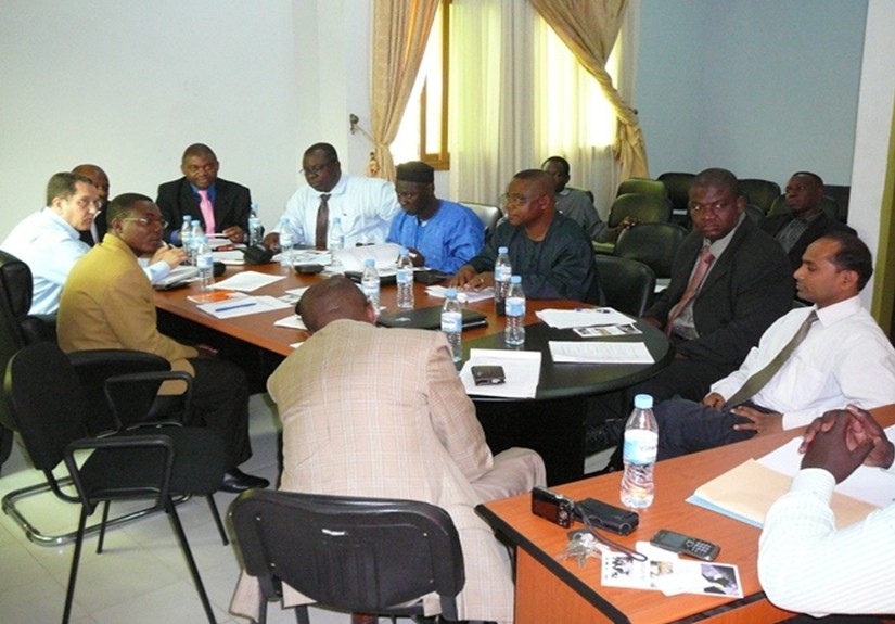
Figure 3. Consultative meeting between TAM team and Local Organizers in Lome, Togo.
Activities of the Regional Support Office in Nigeria in 2010
The activities of the RSO for 2010 are derived from the work plan approved by the United Nations General Assembly for the biennium 2010-2011 documented in A/AC.105/937. The activities implemented are awareness-raising, outreach activities, capacity development, cooperation, knowledge management and transfer, knowledge portal development, support at the national level.
Awareness-Raising
Two major activities were scheduled for 2010. The first was the updating of the RSO website (www.unspider-ng.net) with a Regional Knowledge Portal (RKP). The development of the knowledge portal is a continuous effort. The goal for developing the knowledge portal is to disseminate information on the management of the full disaster cycle using space technology. A segment of the knowledge portal will be dedicated to the exchange of ideas as well as reach-out to the community of practitioners in disaster management. The knowledge portal will consist of news feeds on disaster management, case studies showcasing how space technology was applied in addressing disaster management in Africa, information on access to free space-based data for disaster management (e.g. procedures for invoking the Charter), and links to e-learning tools.
Participation in conferences and space related events is also envisaged. The RSO plans a major awareness-raising event for the 8th Session of the African Association for Remote Sensing of the Environment in Addis Ababa slated for October 25th to 29th 2010.
Outreach Activities
Within the scope of outreach activities, the RSO participated in the following events organised by UN-SPIDER: UN-SPIDER meeting in Vienna from 9th to 12th of February 2010; and Regional Workshop "Building Upon Regional Space-based Solutions for Disaster Management and Emergency Response for Africa, Addis Ababa, Ethiopia, from 6th to 9th July 2010; Fourth United Nations International UN-SPIDER Bonn Workshop on Disaster Management and Space Technology: “The 4C – Challenge: Communication – Coordination – Cooperation – Capacity Development”, Bonn, Germany, from 12th to 14th October 2010.
Capacity Building
Capacity development is a critical component of the activities of the RSO for 2010. As a result, the RSO participated in the following capacity development activities: project Management Training Course for the Charter organised by NEMA and facilitated by DMCii and United States Geological Survey from the 9th to 11th of February 2010; mock activation exercise for Charter on 19th May 2010; course on SARTrix High and Medium Resolution TerraSAR-X Imagery Analysis from June 7th to 18th 2010 organized by NASRDA and facilitated by Terra SAR X Services and Infoterra (an EADS Astrium Company).
Platform for Ensuring Cooperation
A major cooperation for 2010 is between the RSO and NEMA during disaster response activities in Nigeria. In particular, the RSO visited the site of the extensive flooding in Northern Nigeria in September 2010. Following the flood disaster, NEMA activated the Charter. Consequently, the RSO collaborated with NEMA for the processing of the radar image provided during the Charter activation.
Support at the National Level
The RSO provided support to NEMA for the review of the draft Nigerian National Disaster Management Framework. In particular, the RSO recommended the inclusion of space-based approach to disaster management. In addition, the RSO participated in the review of methods for Flood Mapping in Nigeria. Finally, the RSO facilitated the enlisting of NEMA as the UN-SPIDER National Focal Point for Nigeria.
Conclusion
Space-based approach to disaster management is still at its infancy stage. However, application cases have shown that the approach is efficient and cost effective, most especially when a large area is concerned. UN-SPIDER is creating the much-needed awareness on what can be done from space when managing disasters. One of the frameworks for achieving this goal is the use of regional support offices. Although the regional support office in Nigeria was established in 2008, it had tremendous achievements. Some of the achievements include support for technical advisory missions, development of an operational office, participation in outreach activities, awareness-raising, and ensuring that relevant space-based information for disaster management and emergency response is easily accessible and disseminated to all interested end-users.
References
- A/AC.105/929. Report on activities carried out in 2008 in the framework of the United Nations Platform for Space-based Information for Disaster Management and Emergency Response. Committee on the Peaceful Uses of Outer Space, United Nations General Assembly, 14th January 2009.
- A/AC.105/937. United Nations Platform for Space-based Information for Disaster Management and Emergency Response: Workplan for the biennium 2010-2011. United Nations General Assembly, 27 April 2009.
- Briceño, Sálvano 2008. Linking Disaster Risk Reduction and Poverty Reduction. Good Practices and Lessons Learned. A Publication of the Global Network of NGOs for Disaster Risk Reduction. URL: http://www.unisdr.org/eng/about_isdr/isdr-publications/14_Linking_Disaster_Risk_Reduction_Poverty_Reduction/Linking_Disaster_Risk_Reduction_Poverty_Reduction.pdf
- Carr, L.J. 1932. Disasters and the Sequence-Pattern Concept of Social Change. American Journal of Sociology 38, Pp. 207-218.
- Drabek, T.E. 1991. The Evolution of Emergency Management. In Drabek, T.E. and Hoetmer, G.J. (Eds.), Emergency Management: Principles and Practice for Local Government, ICMA, Washington DC, Pp. 3-29.
- Drabek, T.E. and Quarantelli, E.L. 1967. Scapegoats, villains and disasters. Transaction 4. Pp. 12-17.
- Doughty, P. 1971. From disaster to development. Americas 23. Pp. 23-35.
- Eldenman, R. 1952. An approach to the study of disaster. (unpublished paper).
- Fritz, C. and Williams, H. 1957. The human being in disasters: a research perspective. Annals 309. Pp. 42-51.
- Hewitt, K. and Burton, I. 1971. The hazardousness of a place: a regional ecology of damaging events. Toronto: University of Toronto University Press.
- Jager, W. 1977. Katastrophe und Gesellschaft: Gundlegungen und Kritik von Modellen der Katastrophensoziologie. Darmstadt: Luchterhand.
- Jayaraman V., M. G. Chandrasekhar and U. R. Rao 1997. Managing the natural disasters from space technology inputs. Acta Astronautica, 40 (2-8), Pp. 291-325.
- Kreps, G. 1973. Decision making under conditions of uncertainty: Civil disturbance and organizational change in urban police and fire departments. Newark: Disaster Research Centre, University of Delaware.
- Moore, H. 1956. Towards a theory of disaster. American Sociological Review 21. Pp. 734-737.
- Niekerk, Dewald Van 2007. Disaster Risk Reduction, Disaster Risk Management and Disaster Management: Academic Rhetoric or Practical Reality? Journal of the Disaster Management Institute of Southern Africa, 4(1), Pp. 6-9.
- Quarantelli, E.L. 1954. The nature and conditions of panic. American Journal of Sociology 60. Pp. 267-275.
- Quarantelli, E.L. 1957. The behaviour of panic participants. Sociology and Social Research 41. Pp. 187-194.
- Quarantelli, E.L. (Ed.). 1998. What is a disaster? Perspectives on the question. London: Routledge.
- Sorokin, P. A. 1942. Man and Society in Calamity: The Effects of War, Revolution, Famine, Pestilence upon Human Mind. New York: Dutton.
- Torry, W. 1978. Natural disasters, Social structures ad changes in traditional societies. Journal of Asian and African Studies 13. Pp. 167-183.
- Turner, B. 1978. Man-made disasters. London: Wykeham.
- Westgate, K.N. and O'keefe, P. 1976. Some definitions of disaster. Bradford: Disaster Research Institute, University of Bradford.
Contact
Godstime James
Email: godstimej [at] gmail.com
Capacity-building in Earth Observation and Geo-information science – A bridge to knowledge for disaster management in Africa
Capacity-building in Earth Observation and Geo-information science – A bridge to knowledge for disaster management in Africa
Keita Mahamadou S., Deputy Executive Director, Regional Centre for Training in Aerospace Surveys (RECTAS), Ile-Ife, Nigeria
Abstract
Advances in space and information technologies have positively impacted on critical capacity globally through availability of geospatial information technology tools. To be fully utilised however, the space and information technologies must be understood by skilled manpower in Africa to tackle the major challenges in disaster management.
In Africa, the majority of the professionals and technicians in different organisations involved in geospatial information activities have not been making full use of data and tools to manage and alleviate the consequences of natural disasters due to low proficiency in the space technologies. Today there is increasing demands of well-trained staff at all levels, to face the main challenges of disaster management and emergency response. Therefore, it became necessary to provide training and capacity-building in the use of space- and information technologies for different levels of professionals involved in disaster management. This is for the benefit of communities affected by different kinds of hazards. It will involve exchanges and communication between experts and development partners on one hand, and experts and local communities who must also understand and value the use of space technologies to solve their problems, on the other hand.
This paper examines the constraints for manpower development in space- and geo-information technology to tackle numerous disasters occurring in Africa (flood, drought, windstorm, wild fire, famine, epidemic, etc...). The role of capacity-building by training institutions like the Regional Centre for Training in Aerospace Surveys (RECTAS), Ile-Ife, Nigeria in improving the situation and facing the main challenges is emphasized and case studies presented.
Introduction
The impact of natural disasters on the global environment has become increasingly severe over the last decades. The reported number of disasters has risen dramatically, as well as the number of people affected and the cost to global economy. About 95% of the deaths due to disasters occur in developing countries. (Kufoniyi, 2007). While natural disasters have drastically increased in magnitude and frequency, the possibilities of improving the technical capability to mitigate them have also dramatically increased.
Through the current initiatives in and outside Africa, it can be observed that the future orientation of space- and geo-information activities is that they must be available for people who need them for various applications and decision making. The advances in space technology (specifically earth observation satellite technology), with high spectral resolution data has increased the potential of these tools in all scientific and social areas. In disaster management, space-based technologies are used to monitor the environmental situation at certain intervals and to carry out risk analysis by combining the data with detailed local knowledge about the area in combination with geographic information. Therefore, there is a need for pro-active capacity development in all aspects of earth observation and geo-information production, management and use in Africa in order to address the huge capacity gaps. It will require the development of a critical mass of skilled human resources, organisational reforms, technological capacity and institutional strengthening.
The paper presents some important aspects of capacity-building in earth observation and geo-information science that are essential to overcome the challenges of disaster mitigation and emergency response. Recent developments and initiatives are presented. The role and contributions of RECTAS, a regional training-- and research institution in West-Africa, are also highlighted. Recommendations are then advanced to face the challenges of man-power development for disaster management in Africa.
Capacity-building in Earth Observation (EO) and geo-information science
Capacity-building encompasses improvement in the country’s human, scientific, technological, organizational, institutional and resource capabilities. A fundamental goal of capacity-building is to enhance the ability to evaluate and address the crucial questions related to policy choices and modes of implementation among development options, based on an understanding of environment potentials and limits and of needs perceived by the people of the country concerned. (Ayeni, 2008).
The components of capacity-building
The main components of capacity-building are the following:
- Human resource development, the process of equipping individuals with the understanding, skills and access to information, knowledge and training that enable them to perform effectively;
- Organizational development, the elaboration of management structures, processes and procedures, not only within organizations but also the management of relationships between the different organizations and sectors (public, private and community);
- Institutional and legal framework development, making legal and regulatory changes to enable organizations, institutions and agencies at all levels and in all sectors to enhance their capacities.
Capacity-building for the production, management, dissemination and use of geo-information is therefore of immense importance, which requires focused and concerted efforts towards strengthening of national and regional capacity-building institutions including harmonization of methods and concepts.
In the context of human capacity-building, three major groups have been identified as having critical needs of geo-information capabilities:
- Experts in the field of spatial information handling (or specialists in certain aspects of this field);
- Users of space-based technology and geo-information and
- Professionals and policy makers (to enable them to know the importance of geo-information for policy formulation).
Role of capacity-building in disaster management
Training and capacity-building in Earth Observation and Geo-information Science for disaster management / disaster risk reduction will help the experts and stakeholders in the following areas:
- Understand the hazard (where and when and why it is likely to occur);
- Know which areas and communities are most vulnerable to hazards, and what capacities and capabilities are available to cope with disasters;
- Develop knowledge and information resources to enable the risks to be better identified and potential impacts to be adequately assessed;
- Ensure political commitment to disaster risk reduction at various levels, through policy development, legislation, organizational development and promoting community action',
- Increase education and raise awareness of the risks and motivate for changes in collective behavior to reduce risks;
- Understand and take action to mitigate or relieve the socio-economic conditions that create or increase the vulnerability of a community;
- Implement environmental management, physical and technical measures to reduce risks to communities;
- Increase the coping capacity of communities through better communication, improved resources, etc;
- Have a disaster preparedness plan in place. This plan should cover both emergency management and recovery from a disaster;
- Develop hazard monitoring systems and early warning indicators.
Current developments in space- and geo-information capacity requirements
Different issues and events have brought up the need for capacity development efforts in Africa. These include increasing interest of African countries in Space Science and Technology development, National Geospatial Data Infrastructures and National Disaster Management.
- In Space Science and Technology Development, African countries have been involved in the launch of their own earth observation satellites: AlSat-1 (2002) by Algeria and NigeriaSat-1 (2003) by Nigeria. In addition, there has been a significant increase in the awareness of decision makers and civil society in the applications of earth observation satellite data and Geographic Information Systems (GIS). It is essential to match these developments with the manpower development in the applications in disaster reduction and emergency responses (UNECA, 2010).
- In the area of Geospatial Data Infrastructure (GDI), the need for provision of skilled manpower, organisational capacity and institutional reforms has been recognised and is being pursued vigorously now. A good number of countries have already adopted their fundamental datasets and developed their National Spatial Data Infrastructures and Spatially Enabled Government Services with the support of the United Nations Economic Commission for Africa (UNECA) and other partners. To further underpin the importance of capacity-building, the National Geo-information Policies made provision for a training component for all projects, research on new innovations in geoinformatics and its various applications, training in Spatial Data Infrastructure (SDI) concepts, among others.
- In the area of Disaster Management, the strategies developed require to close the gaps for manpower capacity-building. An important role is being played by the United Nations Office for Outer Space Affairs (UNOOSA), through its UN-SPIDER Programme (United Nations Platform for Space-based Information for Disaster Management and Emergency Response) in building capacity and increasing the awareness in the use of space technology for disaster management and emergency response.
- African Geodetic Reference Frame (AFREF), the UNECA continues to work with partners to implement the AFREF programme. The activities include group meetings, workshops and capacity-building to adopt the correct methodologies for the future of AFREF.
RECTAS’ contributions
The Centre and its activities
The Regional Centre for Training in Aerospace Surveys (RECTAS) was established in 1972 under the auspices of the United Nations Economic Commission for Africa (UNECA) to undertake training and research in Geoinformation Science for the manpower needs of African nations. It is situated in the campus of the Obafemi Awolowo University (OAU), Ile-Ife, Nigeria. Currently, the participating member countries are Benin, Burkina Faso, Cameroon, Ghana, Mali, Niger, Nigeria and Senegal.
The main mission of the Centre is to contribute to rapid sustainable development of member states in particular and Africa in general, through the development of critical capacity for timely delivery and responsible use of appropriate geospatial information.
The objectives of the Centre are:
- To provide theoretical and practical training in the field of Geoinformatics, including in particular, photogrammetry, remote sensing, cartography, Geographic Information Systems (GIS) and their applications in geospatial surveys, environmental studies, mapping, natural resources management, etc.
- To conduct seminars, workshops and short courses with a view to providing an opportunity for dissemination of information in the field of Geoinformatics
- To carry out studies and research in the field of Geoinformatics and
- To provide advisory and consultancy services in Geoinformatics and other related areas
From inception in 1972 to date, the Centre has trained 1522 students from 28 African countries (Ikhuoria, 2010). RECTAS has conducted many studies and research, capacity-building and projects execution in different areas of specialisation including disaster management in the participating countries as well as in other countries in Africa. In collaboration with different institutions and partners, the following activities were undertaken:
- Refresher courses in Disaster Management, organised jointly by RECTAS/Nigeria and ITC/Netherlands;
- Short Term Training course in the use of Remote Sensing and GIS in Disaster Management for staff members of the National Emergency Management Agency (NEMA), Nigeria;
- Customised training in Remote Sensing and GIS for staff members of Nigerian Geological Survey Agency (NGSA);
- Customised training in Remote Sensing for staff members of National Space and Research and Development Agency (NASRDA);
- Customised training in GIS and Digital Cartography for Staff members of the National Population Commission (NPopC), Nigeria;
- Participation in UN-SPIDER technical assessment missions and workshops (Abuja, Vienna, Lome, Dakar, etc...);
- Contribution to the activities of the Marine Pollution Monitoring Project in Nigeria;
- Participation in ECOWAS Early Warning workshops in Accra (Ghana) and Dakar (Senegal);
- Organisation of AFREF Experts’ group meeting at RECTAS, Ile-Ife, Nigeria.
Case-studies on disaster management by RECTAS
The following show some case studies by students and staff of the RECTAS:
- Exploration of Remote Sensing and GIS Technology for early Warning in Bush Fire in Benin Republic;
- Use of GIS in Conflict and Crisis Management;
- Monitoring of Desertification in West Africa Using Remote Sensing and GIS techniques
- A GIS approach for prevention and management of flood in Cotonou / Benin Republic
- Identification of flooded areas in Sokoto state in Nigeria using recent Radarsat-2 data (September 2010) – This was undertaken following the flood that occurred in Sokoto state this year. A Radasat-2 scene was downloaded at RECTAS. The result shows the situation of the area viewed by Landsat ETM+ and overlay of flood areas identified with the interpretation of the Radarsat-2 image.
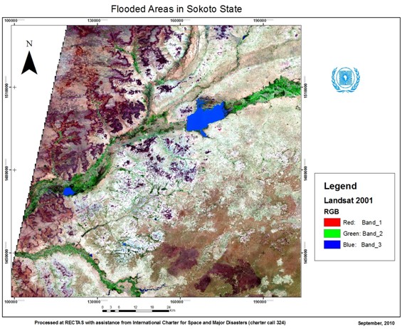
Figure 1: Landsat view of the area under investigation
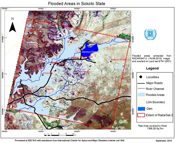
Figure 2: Flooded areas detected by Radarsat-2 (September 2010)
Conclusion and recommendations
This paper particularly emphasizes the use of remotely-sensed data and the access to space-based technology for assessing and monitoring natural hazards. Enhancing the skills in interpreting multi-temporal, multi-date and multi-sources input data has been considered as a priority for developing countries. The relevant data should be made available to communities for early warning and emergency response, mostly to those affected by the major and frequent disasters in Africa. African experts as well as the communities affected by the catastrophes are facing a lot of challenges, including the access to space-based information, human capacity-building, development of appropriate institutions, monitoring of parameters, etc.
However, the following recommendations are made in order to improve the situation and save the lives of people when possible:
- The importance of earth observation and geo-information in disaster management should be amplified.
- Synergies should be developed between technical/financial partners, experts and local communities to improve exchanges and communication.
- Disaster Risk Reduction Networks should be developed.
- Appropriate curriculum on the use of space technologies for disaster management should be developed for training institutions.
- Free or low-cost data can be used (such as ASTER, MODIS, Landsat ETM+, SRTM-DEM, AVHRR, etc.) in order to increase and ease the access to disaster-related data.
- Legal frames should be created to develop standards, monitor parameters and harmonise concepts.
Finally, it should be noted that the continuous capacity-building of experts and communities on a more careful planning for the location, type and durability of developments in and near hazard-prone areas, can definitely reduce losses and enhance the speed of recovery.
References
- Ikhuoria, Isi A., RECTAS: Strategies and Synergy of Accomplishing Objectives, Vision and Collaborative Research (2010).
- UNECA, Report on ECA’s Activities Since the 43rd Meeting of RECTAS Governing Council (2010).
- Bola Ayeni, Building the Capacity of Developing Countries in Disaster Risk Reduction and Management (2008).
- Olajide Kufoniyi, Improving Capacity Building in Earth Observation and Geo-Information Science in Africa through Educational Networking (2007).
Contact
Keita Mahamadou S.
keita [at] rectas.org, ded [at] rectas.org
Examining the effects of the Global Economic Crisis on poverty through natural disasters impacts - An overview of the UNOOSA RIVAF Project
Examining the effects of the Global Economic Crisis on poverty through natural disasters impacts - An overview of the UNOOSA RIVAF Project
Brian Tomaszewski, Ph.D., Assistant Professor, Department of Information Sciences & Technologies, Rochester Institute of Technology
Introduction
This paper presents an overview of the research project “A Visual Analytics Approach to Understanding Poverty Assessment through Disaster Impacts in Africa” that is supported by the Global Pulse Rapid Impact and Vulnerability Analysis Fund (RIVAF) and at the time of this writing, is being implemented by UNOOSA and its partners.
The structure of the paper is as follows. First, I provide the broader context for the project by describing the UN Global Pulse initiative and the Rapid Impact and Vulnerability Analysis Fund (RIVAF) that has the broad goal of investigating the effects of the Global Economic Crisis on the poor and vulnerable. Next, I describe the specific aspects of the UNOOSA RIVAF project such as (a) partnerships (b) goals, and (c) case-study areas. This section is then followed by a brief discussion on the Vulnerability and Visual Analytics theoretical framework that is motivating the research. Instantiation of the Visual Analytics aspects of the theoretical framework is made in the next section through discussion on the Visual Analytic Globe, a prototype Visual Analytic environment being developed to support analytical aspects of the project. The paper concludes with a brief description of the next steps that will be taken in the project, relative to current project progress.
Global Pulse
Global Pulse (GP) (www.unglobalpulse.org/) started in April 2009 as an initiative of U.N. Secretary-General Ban-Ki Moon to “establish a monitoring system to better track the impact of compound crises on vulnerable populations ”. Since its inception, GP has undertaken several initiatives that focused on harnessing technological innovation to monitor and analyze vulnerable populations around the world . One particular global crisis that has been the attention of GP efforts to monitor vulnerable populations is the Global Economic Crisis.
The Global Economic Crisis (GEC) and the Rapid Impact and Vulnerability Analysis Fund (RIVAF)
The Global Economic Crisis is considered to be the worst financial crisis since the Great Depression. The GEC has contributed to a decline in world-wide economic activity, large-scale unemployment, and major financial recovery efforts and commitments by governments. The complex and extensive nature of the GEC lead to the creation in December 2009 of the Rapid Impact and Vulnerability Analysis Fund (RIVAF) within the overall Global Pulse initiative. Specifically, RIVAF was established as a “grant-making mechanism (to) support innovative, real-time data collection and analysis to help develop a better understanding of how vulnerable populations cope with the impacts of global crises” . Fifteen applications were submitted to RIVAF, of which nine, included an application from UNOOSA, were selected. The following section provides an overview of the UNOOSA RIVAF project.
The UNOOSA RIVAF Project
Objectives
The broad objectives of the UNOOSA RIVAF project are to understand the particular effects that the Global Economic Crisis (GEC) has had on the well known relationships between livelihood, poverty, and vulnerability to natural disasters, and to understand how the impacts of natural disasters are potential indicators of GEC impacts on the poor and vulnerable. We hypothesize that the GEC has created a set of unique, previously unexamined circumstances that have negatively affected livelihoods, creating increased poverty conditions and subsequent increased vulnerability to natural disasters.
In particular, the UNOOSA RIVAF project seeks answer to questions such as:
- How specifically have livelihoods been affected by the Global Economic Crisis?
For example, how have livelihoods been affected by global decreased prices for export crops such as cotton in Africa? - How have impacts on livelihood exacerbated vulnerability to natural hazards?
The well known linkages between livelihood and vulnerability are complex. Displacement is one phenomenon that emerges from these linkages. According to the 2010 Consolidated Appeals Process Appeal for West Africa , the current global economic crisis has worsened the phenomenon of displacement in (West Africa). - How do impacts from natural disasters reveal vulnerabilities present before an event and forecast vulnerability after an event?
It is a well-established fact that disasters reveal structural and institutional vulnerabilities, the depth and extent of which are not otherwise overtly apparent until the disaster occurs. For this question, we will investigate relationships between disaster impacts such as loss of agricultural lands, the effects of disaster impacts on livelihoods, and the subsequent effect of livelihood on poverty. A particular focus is being made on using a variety of indicators such as household poverty figures, import/export figures of key African commodities (cotton, palm oil etc.), global remittances, changing land use/land cover patterns, and economic and social disaster impact data to understand GEC impacts on the poor and vulnerable.
Partners
The UNOOSA RIVAF project is implemented in partnership with the UN Economic Commission for Africa, (UNECA), the UN Environment Programme (UNEP), and the Rochester Institute of Technology (RIT). The project teams’ multi-disciplinary mix of cross-UN-agencies coupled with an academic partner was designed to maximize the diversity of scientific- and agency perspectives that can be brought to bear upon the complex nature of the questions being investigated.
Study areas
Two countries are considered in this project. The first is Burkina Faso (BF). BF is a very relevant choice as a focus area due to its economy being impacted by decreased cotton exports, high levels of internal and out-migration, and the widespread state of poverty. The second is Guatemala, another highly relevant focus area due to decreased coffee export prices and environmental degradation (i.e. deforestation) that has affected its economy. Both countries experience natural disasters regularly and thus can offer insights into the effects of the GEC on the relationships between livelihoods, poverty, and vulnerability as reflected in disaster impacts.
Theoretical Framework
In the following sections we outline the theoretical framework underlying our efforts.
The relationships between livelihoods, poverty and vulnerability
We draw upon the Department for International Development’s (DFID) Sustainable Livelihoods Framework for examining the relationships between livelihoods, poverty and vulnerability (Chambers and Conway, 1992, Ashley and Carney, 1999).
In particular, according to the DFID framework, resources required to establish and sustain livelihoods are based on the concept of assets or capitals. A non-exhaustive list of capital examples include human capital, or knowledge, health and skills needed for working, natural capital, or natural resources related to livelihoods such as water, land and bio-diversity, financial capital such as cash and other financial resources, and social capital or social relationships and group memberships which people may draw upon for finding livelihoods (Frankenberger et al., 2002).
From the perspective of capitals, in theory, impoverished people are in an impoverished state because they cannot access or accumulate such capitals. We thus situate the notion of capitals within the context of the research questions of the UNOOSA RIVAF project using the following conceptual framework:
- The Global Economic Crisis impacts access to and accumulation of the aforementioned and other types of capitals.
- Capitals, and thereby livelihoods, are vulnerable to shocks and stresses such as the GEC. For example, the GEC effects global markets that in turn, affects financial capitals of individuals.
- By affecting capitals, the GEC, in turn, increases vulnerability and ultimately makes disasters impacts worse.
In order to support sense making of the three issues within our conceptual framework, we utilize Visual Analytics.
Visual Analytics
The complex and abstract nature of relationships between livelihood, poverty, and vulnerability to natural disasters requires discrete visual representations and computational processing that can support analytical reasoning and decision making to inform policy response, a scientific perspective know as Visual Analytics.
Visual Analytics is the science of analytical reasoning facilitated by interactive visual interfaces, computational methods, and knowledge construction, representation, and management strategies (Thomas and Cook, 2005, Pike et al., 2009). Visual Analytics makes a particular focus on assembling evidence, generating inferences and explanations from evidence, and comparing assessing those inferences and explanations (Pirolli and Card, 2005). The ultimate end goals of visual analytics investigations are the dissemination of results to decision makers and succinct communication of the interpretations made by an analyst or group of analysts (Gershon and Page, 2001)
Technology – The Visual Analytic Globe
The following section provides an overview of the Visual Analytic Globe, a prototype visual analytic environment being developed to provide support analysis of the impacts of the crisis on the poor and/or vulnerable through our research team’s emphasis on developing visually-oriented analytical products such as combined geographic map, timeline and data graph artifacts. Our emphasis on developing visually-oriented artifacts to present research results is theoretically motivated by calls within the United Nations community for the increased use of visualization for decision making (Office for the Coordination of Humanitarian Affairs (OCHA), 2008, Backhaus et al., 2010).
Qualitative analysis using open source media
The visual analytic globe currently supports queries to the Google News and Google News Archives. Google News is used for obtaining current documents about a subject of interest. Google News Archive information is used for potentially understanding how a situation evolved over time, like the GEC (Figure 1).
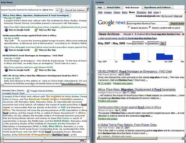
Figure 1: In this example, an analyst is querying Google News archives to find stories about food and migration in Burkina Faso between 2007 and 2008. The analyst can obtain details about any document by clicking on a document title and seeing the named entities that were identified in the raw text (as seen in the bottom left of Figure 1). The term “named entities” refers to people, places, and organizations found in the document, a color coding scheme is applied to support quick scans of the named entities. The color coding scheme used is as follows - people are highlighted in purple, organizations in orange, and places in green.
Queries done to both Google News and Google archives are presented in the search result view seen in the left of Figure 1. The primary purpose of the search result view is to provide quick overviews of the contents of documents foraged by web queries and documents are ranked by their relevance to a given query.
As the visual analytic globe processes each document, place names are extracted, geocoded, and mapped. The integrated map view enables an analyst to explore this derived spatial context through display of the geographic information derived from each document on the map (Figure 2).
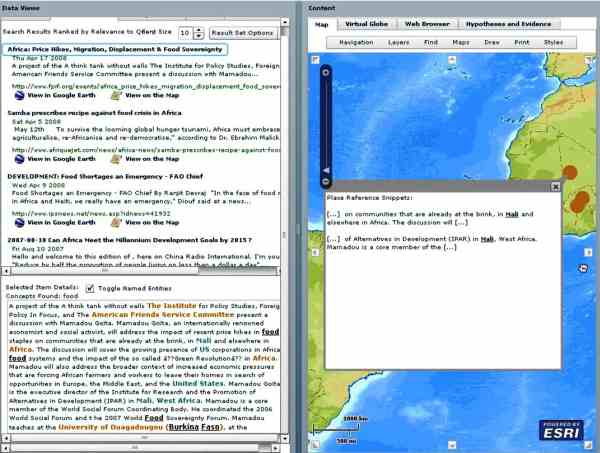
Figure 2: Mapping locations found in news stories.
Integrated Geospatial- and Space-based Technologies
Another goal of the Visual Analytic Globe is to provide the analyst with multiple geospatial views, particularly space-based technology views. These multiple views come in the form of linked Geospatial and Space-based Technologies representations. The visual analytic globe accomplishes this by linking the virtual globe views of Google Earth with 2D Web Map Services (WMS) map images contained within ESRI-based map software (Figure 3).
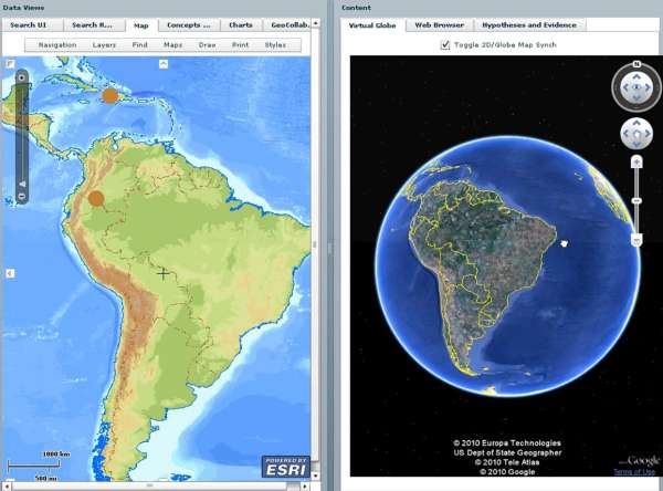
Figure 3: Linked 2D and Virtual Globe views.
For more information on this aspect of the Visual Analytic Globe, see Tomaszewski (2008).
Quantitative Data Analysis
The visual analytic globe also integrated quantitative data views in the form of charts and other graphical data displays (Figure 4).
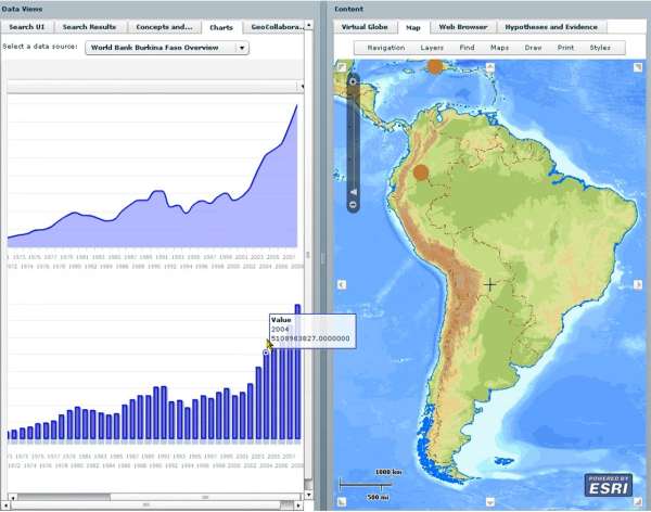
Figure 4: Quantitative data view in the Virtual Globe.
As seen on the left in Figure 4, an analyst has selected the Burkina Faso World Bank data set and examining different variables of interest.
For a full overview of the Visual Analytic Globe and all of its functionalities, see: http://www.youtube.com/watch?v=mo3fLuWHQnM&
Next Steps
The next steps for the UNOOSA RIVAF project are three-fold. First, a major task will be data collection from a wide variety of sources (public, private, NGO, and U.N. agencies) and in varying formats such as (a) geospatial datasets thematically relevant to the project, such as land-use land-cover, (b) satellite- and aerial imagery, (c) open source media analysis, (d) economic and employment statistics, and (d) any other data sets relevant to the project. The second step will be to conduct an extensive data analysis as motivated and informed by the conceptual framework discussed in section 3.1 and technologically supported by the Visual Analytic Globe discussed in section 4. Finally, our project team will develop final reports for submission to the RIVAF committee. In particular, the reports will present our final analysis of the questions discussed in section 2.1. We also hope to present a description of the methodology used on this project that is repeatable in countries other than our study areas. Ultimately, our intent is that our methodology can be re-purposed for future Global Pulse and other efforts aimed at understanding how disaster impacts can potentially reveal vulnerability, and in turn, alleviate human suffering. For future updates on this project, see: http://un-spider.org/rivaf/.
References
- Ashley, C. & Carney, D. 1999. Sustainable livelihoods: Lessons from early experience, Department for International Development.
- Backhaus, R., Czaran, L., Epler, N., Leitgab, M., Lyu, Y. S., Ravan, S., Stevens, D., Stumpf, P., Szarzynski, J. & Leon, J.-C. V. D. 2010. Support from Space: The United Nations Platform for Space-based Information for Disaster Management and Emergency Response (UN-SPIDER). In: ALTAN, O., BACKHAUS, R., BOCCARDO, P. & ZLATANOVA, S. (eds.) Geoinformation for Disaster and Risk Management: Examples and Best Practices. Copenhagen, Denmark: Joint Board of Geospatial Information Societies.
- Chambers, R. & Conway, G. 1992. Sustainable rural livelihoods: practical concepts for the 21st century, Institute of Development Studies, University of Sussex, Brighton, UK
- Frankenberger, T., Luther, K., Becht, J. & Mccaston, M. 2002. Household Livelihood Security Assessments: A Toolkit for Practitioners. Atlanta, GA: CARE USA, PHLS Unit.
- Gershon, N. & Page, W. 2001. What Storytelling Can Do for Information Visualization. Communications Of The ACM, 44, 31-37.
- Office for the Coordination of Humanitarian Affairs (UNOCHA) 2008. Global Symposium +5 on Information for Humanitarian Action: Final Report. In: RELIEFWEB (ed.). Geneva, Switzerland: OCHA Reports.
- Pike, W., Stasko, J. & Chang, R. 2009. The science of interaction. Information Visualization, 8, 263-274.
- Pirolli, P. & Card, S. Year. The Sensemaking Process and Leverage Points for Analyst Technology as Identified Through Cognitive Task Analysis. In: International Conference on Intelligence Analysis, 2005 McLean, VA. 1-6.
- Thomas, J. J. & Cook, K. A. 2005. Illuminating the Path: The Research and Development Agenda for Visual Analytics, Los Alametos, CA, IEEE.
- Tomaszewski, B. 2008. Producing geo-historical context from implicit sources: a geovisual analytics approach. The Cartographic Journal, 45, 165-181.
Contact
Brian Tomaszewski, Ph.D., Assistant Professor
Department of Information Sciences & Technologies
Rochester Institute of Technology
31 Lomb Memorial Drive
Rochester, NY 14623, USA
phone: +1 585-259-9678
http://people.rit.edu/bmtski/
bmtski [at] rit.edu
From policies to action: Institutionalizing the use of space-based information in disaster-risk management and emergency response in Latin America
From policies to action: Institutionalizing the use of space-based information in disaster-risk management and emergency response in Latin America
Juan Carlos Villagran de Leon, Programme Officer, United Nations Office for Outer Space Affairs, United Nations Platform for Space-based Information for Disaster Management and Emergency Response (UNOOSA/UN-SPIDER)
Introduction
One of the tasks of UN-SPIDER, as stated in its mandate given by the General Assembly, is to enhance the capacities of countries to access and to use all types of space-based information for disaster management. In order to identify how to strengthen the capacity of disaster-risk management and emergency response agencies of using space-based information, UN-SPIDER has been conducting Technical Advisory Missions to countries in different regions of the world, including Latin America and the Caribbean. Such missions include a review of policies and strategies concerning access and use of information, particularly space-based information, and serve as the basis for UN-SPIDER to provide technical advisory support to government agencies. Within Latin America and the Caribbean, UN-SPIDER has conducted these types of missions to Ecuador, Dominican Republic, Jamaica, and Guatemala during 2009 and 2010.
As stated in UN-SPIDER’s Capacity Building Strategy (1), the sustained use of space-based information in tasks related to disaster-risk management and emergency response is supported through institutional policies and strategies. Such policies and strategies manifest the institutional recognition of the value of using this type of information, as well as any other type of information to make decisions; and allow directors of such institutions to channel resources towards the generation and use of information.
This article focuses on the review of existing policies and strategies for the use of space-based information in the above-mentioned Latin American countries, and stems from the research conducted by experts who have participated in the Technical Advisory Missions conducted to these countries. The comparative review aims to manifest advances on the use of such information in these countries, as well as additional efforts that would allow such countries to take even more advantage of existing opportunities concerning space-based information.
The generation, dissemination, and use of information within the context of national policies targeting disaster risk management and emergency response
While the use of any type of information for a variety of purposes usually starts with ad-hoc efforts, the institutionalization process begins to take shape when policies are enacted, as such policies facilitate the permanent allocation of the required resources to conduct the various tasks that are involved in the use of information. Furthermore, approaches to using space-based information in the context of disaster-risk management and emergency response vary from country to country. In some countries such as Ecuador, Jamaica, the Dominican Republic, and Guatemala, the use of space-based information has progressed initially via efforts focusing on environmental management including the proper or sustainable use of natural resources, and is gradually finding its way into emergency response, and to a lesser degree into disaster-risk management. In Ecuador the use of space-based information, particularly via remote-sensing approaches, began through a particular circumstance whereby the Center for the Integrated Acquisition of Information on Natural Resources (CLIRSEN) (2) was established in 1977 to elaborate the inventory of natural resources at the national level, and in 1982 it received the mandate from the Government of Ecuador to take over the satellite receiving station which was installed by the National Air and Space Administration of the United States (NASA) in 1957 in the foothills of the Cotopaxi volcano in Ecuador. In recent decades, CLIRSEN has been promoting the application of space-based information for a variety of purposes and has contributed through the provision of data to institutions such as the Geophysical Institute of the National Polytechnic School (EPN) which tracks volcanic activity and the Institute of Geology, which is in charge of tracking landslides throughout the country. A similar situation is found to this day in the Dominican Republic, in Jamaica, and in Guatemala, where satellite imagery is used to a larger extent by Ministries of Environment to track forests and natural resources.
Taking into consideration the fact that space-based information can be used for a variety of purposes, its use in the context of disaster-risk management and emergency response is reviewed in this article through those policies and strategies that have been explicitly enacted and implemented to target both these phases of the disaster management cycle. But as it is to be expected, it is essential to begin the review analyzing how information, whether it is space-based, or ground-based, is being recognized at this policy level. In this more general context, it could be stated that Ecuador again has taken considerable steps regarding the use of information at the highest policy level. In the new Constitution enacted in 2008, the Government introduced specific legislation focusing on disaster-risk management through Articles 389 and 390 (3). The policy recognizes the need to establish the National De-Centralized Disaster-Risk Management System, highlighting the need to identify risks and to generate and disseminate information on a timely basis for risk-management purposes. However, the legislation does not mention space-based information in an explicit fashion.
In other countries, the use of information for disaster-risk management has not been incorporated at the high level of the constitution, but it has been introduced through specific legislation enacted by the respective Congresses. In the case of the Dominican Republic, the national law No. 147-02 was enacted in 2002 to establish the National System for Prevention, Mitigation, and Disaster Response (4). Article 15 of this legislation delegates the establishment of the National Integrated Information System to the National Emergency Commission (CNE), which should target the generation of information concerning hazards, vulnerabilities, and risks throughout the country. In Jamaica, the Disaster Management Act No. 15 of 1993 established the Office for Disaster Preparedness and Emergency Response (ODPEM) and included a specific function that targeted the generation of information on hazards, with the aim of identifying and analyzing such hazards or emergency situations and conducting operational research into their effects. Finally, in Guatemala, the National Decree 109-96 (5), which established the National Coordinating Agency for Disaster Reduction (CONRED), also recognized the need to conduct research targeting hazards, vulnerability, and risk.
As it can be seen, the need to generate information on hazards, vulnerabilities, and risk is recognized as essential at the highest policy level, and should serve as the basis to institutionalize the generation and subsequent dissemination of the corresponding information. However, as stated earlier, none of these legislations enforces the use of this information explicitly. Nevertheless, it is important to recognize that meteorological agencies in these and other countries around the world have institutionalized the use of space-based data and information gathered from meteorological satellites through specific institutional policies.
While access to space-based data and imagery follows similar patterns in these four countries, the use of such data and imagery targeting disaster-risk management and emergency response varies from country to country. All of these countries are aware of the service provided by the International Charter Space and Major Disasters (Charter) and have benefited from its products on various occasions.
Spatial Data Infrastructures
In addition and recognizing the value of space-based data for a variety of purposes, all these countries are embarking on the establishment of National Spatial Database Infrastructures (NSDIs) as a means for institutions to share and exchange information. In most cases, such NSDIs have been established by the National Planning Agencies, given their strategic role in coordinating activities conducted by all government agencies. In Guatemala, the General Secretariat for Planning and Programming of the Presidency (SEGEPLAN) has not only aims at establishing the NSDI, but plays a critical role in making use of space-based information to track the impacts of recent disasters as tropical storm Stan in 2005, and most recently the tropical storm Agatha in 2010; and to develop the National Territorial Planning System (6).
In the case of Ecuador, the National Secretariat for Development Planning (SENPLADES) is establishing the NSDI and has also established the National Geo-Informatics Council (CONAGE) as an inter-institutional mechanism to ensure that the proposed aims of the NSDI are reached (7). As it is stated in the Executive Decree No. 2250 of 2004 (8), the State of Ecuador recognizes “the need to promote the integration of producers and users of geographic information as a pillar to support social and economic activities, and to promote sustainable and integral development of the country”. In addition, SENPLADES is also in charge of the National Territorial Information System. In the context of satellite imagery, SENPLADES sees the utility of the NSDI as a strategy to elaborate the national inventory of satellite imagery, which aims to avoid duplication in the purchase of imagery by different government agencies.
In Jamaica, the Spatial Data Management Division (SDMD) in recent years has been working towards the establishment of the NSDI, and also contributes with ODPEM in case of disasters. The Division was originally established by the Land Information Council of Jamaica, but recently it was moved to the Office of the Prime Minister given its strategic relevance concerning planning efforts. A parallel effort is being conducted by the Planning Institute of Jamaica (PIOJ) through the elaboration of the National Spatial Plan, which targets the development of an inventory of existing geo-spatial data to determine how it has been used and to detect existing gaps.
In the Dominican Republic, efforts to establish such a NSDI are still in an embryonic stage at the time this article is being written. Nevertheless, many agencies share the view concerning the benefits that an NSDI would bring in terms of facilitating the exchange and sharing of information.
Strategies and policies targeting the training of staff
Two key issues to consider when it comes to using space-based information in disaster-risk management and emergency response activities are the knowledge and the skills of staff who are responsible for the generation of information using ground- and space-based data. Taking into consideration the fast pace of advances regarding information technologies, UN-SPIDER recognizes the relevance of institutional policies and strategies targeting the continuous training of staff, so that institutions can continue to take advantage of emerging opportunities.
A review of the respective legislation in these four countries allows UN-SPIDER to conclude that several countries do recognize the need for training. In the National Law 147-02, the State of the Dominican Republic recognized that “despite the fact that for several years disaster response organizations have promoted training initiatives to improve emergency response capacities, today it is necessary to conduct a permanent training programme on integral risk management through instruments previously elaborated with the support of diverse agencies targeting the municipal, provincial, and national levels”. To this end, this national law instructs the National System for Prevention, Mitigation, and Disaster Response to develop a training system on risk management targeting staff of the government and communities; and to strengthen institutional capacities on this topic at the provincial and municipal levels.
In the case of Jamaica, the Act of 1993 recognized the need for ODPEM to provide training programmes in all aspects of disaster preparedness, mitigation, loss reduction, and disaster management. Furthermore, the National Land Policy enacted in 1996 also recognized the need for ongoing training in geographic information systems to be maintained and institutionalized in the curriculum at the Management Institute for National Development, the University of the West Indies, and the University of Technology. In a similar fashion, the Jamaica Water Sector Policy recognized the need for capacity strengthening for effective, efficient, and equitable solutions to the challenges of water resource management and development.
However, when it comes to the implementation level, it is Ecuador, which has the lead through CLIRSEN that has now established its second training center in Guayaquil to fill the demand there. Taking into consideration its Mandate, its Mission, and its Vision (9), CLIRSEN has established 3 strategies:
- To facilitate access to satellite images as an intermediary between space agencies, which produce such images and the end user who needs them.
- To conduct research and to provide technical assistance to institutions on the use of this type of information.
- To train staff in all aspects related to this type of information (access, processing, and use).
CLIRSEN is cooperating with the National Secretariat on Risk Management and with other agencies in the use of space-based information to generate information on hazards and risks in case of floods, earthquakes, volcanic eruptions, and landslides.
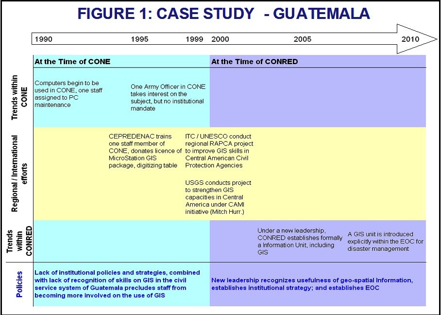
Detecting the institutionalization process in a developing country
While the evolution regarding the use of information has been somewhat different in every country, Guatemala presents an interesting case from which many conclusions can be drawn that are representative of trends in other developing countries. Guatemala, like other countries, is exposed to a variety of hazards such as earthquakes, floods, and landslides. Between 1969 and 1996 the national policy on the issue of disasters was focused on response, and so the National Emergency Committee (CONE) was established in 1969. By the late 1980s, computers began to be used for managerial processes in CONE, but there was no institutional policy on the use of geo-spatial information for such purposes. Between 1990 and 1995, there was one staff member who was assigned to provide maintenance to PCs. Between 1995 and 1998, an Army Officer assigned to CONE took interest on GIS, but the use of such systems was not institutionalized yet.
Between 1992 and 2003, various regional and international initiatives conducted by the Central American Coordination Center for Natural Disaster Prevention (CEPREDENAC), ITC in the Netherlands in conjunction with UNESCO, and the United States Geological Survey (USGS) focused on enhancing the skills of staff on the use of GIS. An initial project was conducted by CEPREDENAC between 1992 and 1994, focusing on the training of one staff per country on the use of GIS. Soon after hurricane Mitch at the end of 1998, both ITC/UNESCO and USGS launched regional projects again targeting the training of staff on the use of GIS in government institutions devoted to risk management and emergency response.
In December of 1996, the Congress of Guatemala enacted the National Decree-Law No. 109-96, transforming CONE into CONRED. The institutional transition from CONE to CONRED took slightly over two years to be completed and was accompanied by a change in the leadership within the institution, and by 2001 the new Executive Director of CONRED officially established an information management unit, which included one staff member dedicated to GIS tasks. By 2008, a GIS sub-unit was established within the National Emergency Operations Center (EOC), and is staffed on a 24/7 basis by staff with skills on the use of GIS to generate maps visualizing the impacts of disasters and any other pertinent information. The process of institutionalization is shown in figure 1.
It should be stated that in Jamaica, Ecuador, and Dominican Republic, disaster-risk or civil protection agencies are also using GIS on an institutional basis, and in the corresponding EOCs as well. And with the support of UN-SPIDER, these and other countries are gradually incorporating the use of space-based information in a complementary fashion.
The Role of UN-SPIDER in promoting the use of space-based information
As it has been stated in the introduction, UN-SPIDER has been established to promote the use of all types of space-based information to support the full disaster management cycle. To achieve this goal, UN-SPIDER is promoting the institutionalization of the use of such information in these countries. The first step along these lines is the conduction of a Technical Advisory Mission that aims to identify strengths and weaknesses. Such missions have already been conducted in these four countries and allow UN-SPIDER to identify whether policy-relevant advice is needed, or whether the need is already more in terms of strategies or activities targeting training or institutional support.
In the coming years, UN-SPIDER will provide technical advisory support to these and other countries around the world, which have already officially requested such support. Efforts in Africa are now focusing on Western and Central African countries; and there is a similar approach in Small Island Developing States in the Pacific and the Indian Ocean. In all cases, the conduction of the Technical Advisory Missions allows UN-SPIDER to tailor its capacity building efforts so that these countries can begin to take advantage of emerging opportunities concerning space-based information.
Conclusions
The use of space-based information is still evolving in many developing countries. However, policies embedded in the new legislation in many of these countries are promoting both the generation and dissemination of information. And while the use of space-based information is not mentioned explicitly, it is important to recognize that there are no restrictions for its use in such policies either.
A review of policies on the generation and use of information in the Dominican Republic, Ecuador, Guatemala, and Jamaica; and the recent establishment of geographic information units in agencies responsible for disaster-risk management and emergency response in these countries leads to the conclusion that the use of this type of information is being recognized by decision makers, and is paving the way for its corresponding institutionalization.
So far, all of these countries have made use of space-based information in the case of disasters through support delivered by the Charter. But it must be stressed that Ecuador has been able to take advantage of space-based information through CLIRSEN. Being a local institution, CLIRSEN facilitates access to space-base information, the training of staff, and can support in the generation of useful information based on satellite imagery. In addition, it is also important to highlight the fact that the use of space-based information began in these and other countries more in the area of environmental protection, particularly in the context of protected areas and natural resources.
It is expected that through the efforts conducted by UN-SPIDER and other regional and international organizations, countries like Guatemala, Dominican Republic, and Jamaica can follow on the footsteps of Ecuador and take advantage of the opportunities that are available regarding space-based information.
References
- Ref.: A/AC.105/937; pages 3-6
- See: http://www.clirsen.com
- Ref.: Asamblea Constituyente de la República del Ecuador. Constitución 2008. Available in: http://www.asambleanacional.gov.ec/documentos/constitucion_de_bolsillo.pdf
- Ref: Congreso Nacional Presidencia de la Republica Dominicana. Ley Nacional 147-02. Available in: http://www.coe.gov.do/index.php?option=com_content&view=article&id=18&Itemid=48.
- Congreso de la República de Guatemala, Decreto Legislativo 109-96. Available in: http://www.undp.org.gt/data/bases/596_Nota_Aclaratoria_1-adjunto.pdf.
- Available in: http://sinit.segeplan.gob.gt/
- Decreto Ejecutivo No. 2250 published in Registro Oficial Nº 466 on 22 November 2004 , available in: http://territorial.sni.gov.ec/images/stories/actas/CONAGE/decreto_conage.pdf.
- Available in: http://territorial.sni.gov.ec/images/stories/actas/CONAGE/decreto_conage.pdf.
- See: http://www.clirsen.com/clirsen/index.php?option=com_content&task=view&id=12&Itemid=32
Geo-information infrastructure for disaster management in Ukrainian UN-SPIDER Regional Support Office
Geo-information infrastructure for disaster management in Ukrainian UN-SPIDER Regional Support Office
Nataliia Kussul, Andrii Shelestov, Sergii Skakun
Space Research Institute NASU-NSAU, Ukraine
Introduction
Presently, global climate change on the Earth made a rational land use, environmental monitoring, prediction of natural and technological disasters tasks of great importance. The basis of the solution for these crucial problems lies in the integrated use of data of different nature: modeling data, in-situ measurements and observations, and indirect observations such as airborne and space borne remote sensing data [1].
In particular, models can be used to fill in the gaps in data by extrapolating and estimating necessary parameters to the site of interest and to better understand and predict different processes occurring in the atmosphere, land, ocean and sea, etc; they can also help to interpret measurements and to design new observing systems. In-situ measurements are often used for assimilation into models, calibration and validation of both modeling and remote sensing data. Satellite observations have an advantage of acquiring data for large and hard-to-reach areas, as well as providing continuous and human-independent measurements. Many important applications such as monitoring and predictions of natural disasters, environmental monitoring, etc. heavily rely on the use of Earth Observation (EO) data from space. For example, satellite-derived flood extent is very important for calibration and validation of hydraulic models to reconstruct what happened during the flood and determine what caused the water to go where it did [2]. Information on flood extent provided in the near real-time (NRT) can also be used for damage assessment and risk management, and can also benefit rescuers during flooding. Both space-borne microwave and optical data can provide means to detect drought conditions, estimate drought extent and assess the damage caused by the drought events [3, 4]. To assess vegetation health/stress, which is extremely important for agriculture applications, optical remote sensing data can be used to derive biophysical and biochemical variables such as pigment concentration, leaf structure, water content at leaf level and leaf area index (LAI), fraction of photosynthetically active radiation absorbed by vegetation (FPAR) at canopy level etc. [5].
The EO domain is characterized by the large volumes of data that should be processed, catalogued, and archived [6, 7, 8]. The processing of satellite data is carried out not by a single application with a monolithic code, but by distributed applications. This process can be viewed as a complex workflow [9] that is composed of many tasks: geometric and radiometric calibration, filtering, reprojection, composites construction, classification, products development, post-processing, visualization, etc. For example, calibration and mosaic composition of 80 images generated by the ASAR instrument onboard the Envisat satellite takes three days on ten workstations of an Earth Science GRID on Demand that is being developed at ESA and ESRIN [6]. Dealing with EO data, we have to also consider the security issues regarding satellite data policy, the need for processing in NRT for fast response within international programs and initiatives, in particular the International Charter "Space and Major Disasters".
It should be also noted that the same EO data sets and derived products can be used for a number of applications. For example, information on land use/change, soil properties, meteorological conditions etc. is both important for floods- and droughts-related applications as well as for vegetation state assessment. That is, once we develop interfaces to discover and access the required data and products, they can be used in a uniform way for different purposes and applications. This represents one of the important tasks that are being solved within the development of the Global Earth Observation System of Systems [1] and the European initiative Global Monitoring for Environment and Security [10]. Services and models that are common for different EO applications (e.g. flood monitoring and crop yield prediction) are shown in Figure 1.
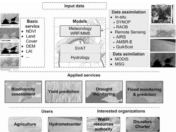
Figure 1. Common services and models for a variety of applications
A considerable need therefore exists for an appropriate geospatial infrastructure that will enable the integrated and operational use of multi-source data for different applications domains. In this paper, we focus on the description of service-oriented infrastructure that is being developed in the Space Research Institute NASU-NSAU (SRI NASU-NSAU). We will describe several real-world applications that are addressed using the infrastructure, namely flood- and fire monitoring. The geospatial services developed within the infrastructure are delivered to end-users through the UN-SPIDER Regional Support Office in Ukraine that was established in February 2010.
Service-oriented infrastructure for satellite data processing
One of the most important problems associated with satellite data processing for disaster management is the timely delivery of information to end-users. To enable such capabilities, an appropriate infrastructure is required to allow for rapid and efficient access to, processing and delivery of geospatial information that is further used for damage assessment and risk management. In this section, we will describe the overall architecture of such a system and show how it is being used for automated acquisition, processing and visualization of satellite Synthetic-Aperture Radar (SAR) and optical data for rapid flood mapping and fire monitoring. The developed services are used within the UN-SPIDER Regional Support Office in Ukraine, that was established in February of 2010.
Overall Architecture
Within a system we developed a set of services (Fig. 2). We followed an approach that is used in the Earth System Grid [11]. The four major components of the system are as follows:
- Client applications. Web portal is a main entry point, and provides interfaces to communicate with system services.
- High-level services. This level includes a security subsystem, catalogue services, metadata services (description and access), automatic workflow generation services, and data aggregation, sub-setting & visualization services. All these services are connected to Grid services at the lower level.
- Grid services. These services provide access to the shared resources of the Grid system, access to credentials, file transfer, job submission and management.
- Database and application services. This level provides physical data and computational resources of the system.
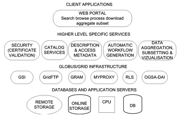
Figure 2. System architecture
Workflow of flood extent extraction from satellite (SAR) imagery
Within the infrastructure we developed an automated workflow of satellite SAR data acquisition, processing and visualization, and corresponding geospatial services for flood mapping from SAR imagery. The data are automatically downloaded from ESA rolling archives where satellite images are available within 2-4 hours after their acquisition. We implemented both programming and graphical interfaces to enable search, discovery and acquisition of data (Fig. 3). Through the portal the user can select a geographical region of interest and a time range, and find the data that matches the search request. After the user selects a file to be processed, it is transferred to the resources of the Grid system at the Space Research Institute NASU-NSAU. Following that, a workflow is automatically generated and executed on the resources of the Grid infrastructure.
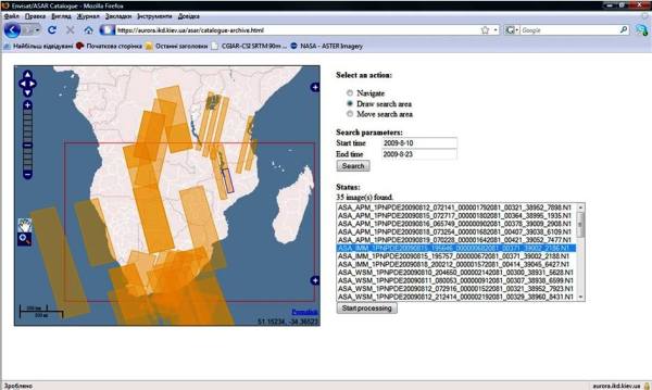
Figure 3. Portal for flood mapping from satellite SAR data
We developed a neural network approach to SAR image segmentation and classification [8]. The workflow of data processing is as follows (Fig. 4):
- Data calibration. Transformation of pixel values (in digital numbers) to backscatter coefficient (in dB).
- Orthorectification and geocoding. This step is intended to remove geometrical and radiometric errors associated with SAR imaging technology, and apply corrections to provide precise georeferencing of the data.
- Image processing. Segmentation and classification of the image using neural network.
- Topographic effects removal. Using a digital elevation model (DEM), such effects as shadows are removed from the image. The output of this step is a binary image classified into two classes: “Water” and “No water”.
- Transformation to geographic projection. The image is transformed to a projection for further visualisation via Internet using OGC-compliant standards (KML or WMS) or desktop Geographic Information Systems (GIS) using shape file.
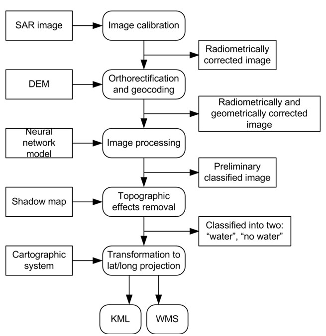
Figure 4. Workflow of flood extent extraction from SAR satellite imagery
After processing the user request from the portal, such a workflow is automatically generated and is executed on the resources of the Grid system. Through the portal the user can monitor the status of each step of the workflow. After the workflow is completed, a flood map is delivered to the user via OGC-compliant standards.
Application services
Flood monitoring
The above-described infrastructure is used within the Ukrainian UN-SPIDER RSO to produce flood maps all over the World. For this purpose, we use both optical and SAR satellite data, in particular Envisat/ASAR, Radarsat-1/2, EO-1 and Landsat-5.
Flood Monitoring in Ukraine 2010
The severe 2010 winter in Ukraine that was characterized by large amounts of snow and ice on rivers posed a high threat of floods during the melting period. A lot of efforts have been made by the Ukrainian Government to prevent and reduce consequences of potential disasters. The UN-SPIDER Regional Support Office (RSO) in Ukraine that was established at the Space Research Institute (SRI) NASU-NSAU in the beginning of 2010 played an active role in these efforts.
In order to provide flood risk assessment both synthetic-aperture radar (SAR) and optical satellite imagery were used. In particular, we acquired more than 30 Envisat/ASAR scenes during the 2010 winter-spring period, and more than 50 archived scenes during autumn 2009 to monitor the snow cover. Using the Sensor Web system we acquired 3 scenes from NASA’s EO-1/ALI instrument. Timeline of delivery of satellite images and products in case of a disaster in this particular case Ishould be emphasized (Fig. 5). For example, for the EO-1 April image we received a notification on EO-1 tasking for the target area on Monday Apr 12, 2010 @10:33 PM local time. The image was taken on Tuesday Apr 13, 2010 @11:33 AM and was made available on ftp the same day @04:30 PM. A pan-sharpened image was available as KML on the web Tue Apr 13, 2010 @11:30 PM after only 12 hrs from time the image was taken. Figure 6 shows changes in snow cover and ice formation on the Dnieper River near the Kyiv city area.
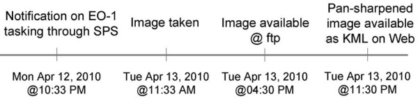
Figure 5. Timeline of EO-1 / Advanced Land Imaging for the 13 April image
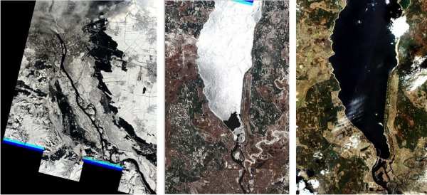
Figure 6. EO-1 images of Kyiv area for 10 March (left), 23 March (middle) and 13 April, 2010 (right). Left image shows strong presence of snow cover in early March. From the image taken on 23 March it can be seen that snow has already melted while there is still an ice cover on the river (on top). This ice posed a high threat to the houses and constructions along the river. Right image shows no snow or ice on the land and the river. Data courtesy of the NASA Earth Observing One (EO-1) Mission operated by the NASA Goddard Space Flight Center.
The produced geospatial products were delivered to the Ukrainian Ministry of Emergency Situations, the Council of National Security and Defense, and the Ukrainian Hydrometeorological Center. Information on river extent that was derived from EO-1 images was also used to calibrate and validate hydrological models to produce various scenarios of water extent for flood risk assessment.
Flood Monitoring in Namibia 2010
The UN-SPIDER RSO in Ukraine is also actively involved in the Namibia SensorWeb Pilot Project – a joint effort of UNOOSA/UN-SPIDER, NASA, NOAA, DLR and SRI NASU-NSAU. SRI’s main role lies in rapid flood mapping from SAR satellite imagery. More than 20 scenes from the Envisat/ASAR instrument have already been acquired for Namibia during 2010, and corresponding flood maps were produced. Figure 7 shows an example of one of these products. This information along with information and products provided by the project partners will be used for the integrated analysis of floods in Namibia.

Figure 7. Flood extent shown in light-blue derived from Envisat/ASAR Wide Swath Mode imagery on 30 May, 2010. Image covers Caprivi region of Namibia. (Image copyright ESA 2010)
Integration of ground and satellite data to validate flood products
In order to provide validation of flood mapping products, ground data were collected during a U.N. Technical Advisory visit in Namibia (25-27 January 2010). These data were collected with a camera and GPS. Corresponding satellite imagery was acquired to support the field campaign (Fig. 8), in particular:
- Envisat/ASAR, 30 January 2010,
- Landsat-5/TM, 26 January 2010.
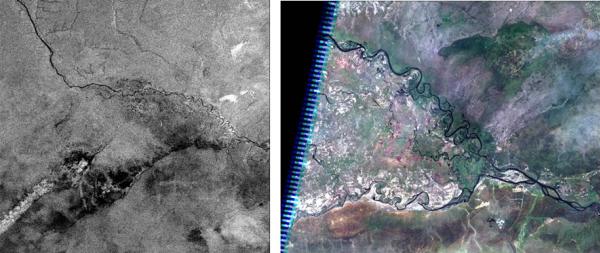
Figure 8. Envisat/ASAR acquired on 30 January 2010 (left) and Landsat-5/TM acquired on 26 January 2010 (right) covering Caprivi region of Namibia
The satellite images and photos that were geo-tagged were integrated in the Google Earth application.
Figure 9. Integration of Envisat/ASAR imagery and ground photos with Google Earth. Note that open flat water appears black (with low backscatter coefficient) on radar imagery while water with vegetation appears bright.
Fire monitoring
The 2010 summer in Ukraine was characterized by extremely high temperatures that posed a high risk of fires. In particular, the temperature exceeded +35-39ºC in Eastern regions of Ukraine, and +40-42ºC in Southern regions. According to the Ministry of Emergency Situations of Ukraine approximately 3000 fires were detected from 5 to 20 August (that constitutes approx. 200 fires per day), 2200 of them were forest fires with an area of 6500 ha being affected. In order to enable monitoring and detection of fires the following satellite data sets were used:
- EO-1/ALI, acquired on 14.08.2010 08:15 UTC
- Landat-5 TM, acquired on 02.08.2010 08:15 UTC
- Fire services provided by Center for Satellite Based Crisis Information (ZKI) of DLR
Figures 10 and 11 show fire detection products from Landsat-5 TM imagery and MODIS, respectively.
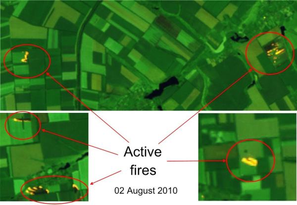
Figure 10. Active fires detected by Landsat-5/TM
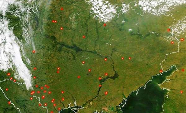
Figure 11. Hotspots detected by MODIS
Conclusions
In this paper we describe service-oriented infrastructure for disaster management based on satellite data. The infrastructure exploits a number of generic services to enable access to, processing and delivery of geospatial information. In particular, within the system we developed an automated workflow of satellite SAR data acquisition, processing and visualization, and corresponding geospatial services for flood mapping from SAR imagery. This allows us to produce flood maps within 24 hours after data acquisition. Using ground data that were collected during a U.N. Technical Advisory Mission in Namibia we provided validation of flood maps generated from SAR imagery. While the open water can be detected easily from SAR imagery, detection of water with strong vegetation cover represents an issue. Another application that is covered in the paper is fire monitoring. The use of satellite data with different spatial resolutions and coverage allowed us to provide both national and regional detection of fires.
References
- The Global Earth Observation System of Systems (GEOSS) http://www.earthobservations.org.
- M.S. Horritt, A methodology for the validation of uncertain flood inundation models. J. of Hydrology, 326, 153-165 (2006).
- F. Kogan, R. Stark, A. Gitelson, E. Adar, L. Jargalsaikhan, C. Dugrajav, and S. Tsooj, Derivation of Pasture Biomass in Mongolia from AVHRR-based Vegetation Health Indices. Int. J. Remote Sens, 25(14), 2889-2896 (2004).
- W. Wagner, C. Pathe, D. Sabel, A Bartsch., C. Kuenzer and K. Scipal, Experimental 1 km soil moisture products from ENVISAT ASAR for Southern Africa, ENVISAT and ERS Symposium, Montreux, Switzerland, 23-27.04.2007.
- S. Liang, Quantitative Remote Sensing of Land Surfaces, Wiley, Inc., 534 p (2004).
- L. Fusco, R. Cossu and C. Retscher Open Grid Services for Envisat and Earth Observation Applications. In: Plaza AJ, Chang C-I (ed) High performance computing in remote sensing, 1st edn. Taylor & Francis Group, New York, 237-280 (2007).
- A. Shelestov, N. Kussul and S. Skakun Grid Technologies in Monitoring Systems Based on Satellite Data. J. of Automation and Inf. Sci., 38(3), 69-80 (2006).
- N. Kussul, A. Shelestov andS. Skakun, Grid System for Flood Extent Extraction from Satellite Images. Earth Science Informatics, 1(3-4), 105-117 (2008).
- Project: Dissemination and Exploitation of Grids in Earth Science, https://www.eu-degree.eu.
- The European Earth Observation Programme (GMES). http://www.gmes.info.
- D.N. Williams et al, Data management and analysis for the Earth System Grid. J. Phys.: Conf. Ser. 125 012072. (2008) doi: 10.1088/1742-6596/125/1/012072
Supporting projects addressing climate change issues and associated disaster risk reduction: The Planet Action Initiative
Supporting projects addressing climate change issues and associated disaster risk reduction: The Planet Action Initiative
Algis B. Kucinskas, Planet Action, Spot Image* Individual Partner, Paris, France
This paper gives an overview of the Planet Action (PA) non-profit collaborative initiative with particular focus on its project support activities. PA was launched in 2007 to encourage the Earth observation and geographic information professional communities to help NGOs, local institutions and universities tackle climate change in a new cooperative approach.
General background / international communities’ needs
Following the conclusions of the Fourth Assessment Report of the Intergovernmental Panel on Climate Change (1, 2, 3) (IPCC, AR4, 2007) as well as updates from the 2009 Copenhagen Diagnosis (4) , it is now generally agreed that the Earth is currently experiencing large-scale climate change of both natural and anthropogenic (human-induced) causes with imminent and future adverse impacts on human society and the environment.
Indeed, as an evidence of observed climate change, there is now a very strong body of observational evidence showing that there has been an unusual increase in the global average (mean) temperature of the Earth’s lower atmosphere over the past century, with a particularly rapid increase since the mid-20th century. This upward trend in measured global mean temperatures and its projected continuation is often referred to as “global warming”. It is illustrated in Figure 1a and b, taken from the Copenhagen Diagnosis (4) (with data from NASA Goddard Institute for Space Studies/GISS and the Hadley Centre for Climate Prediction and Research).
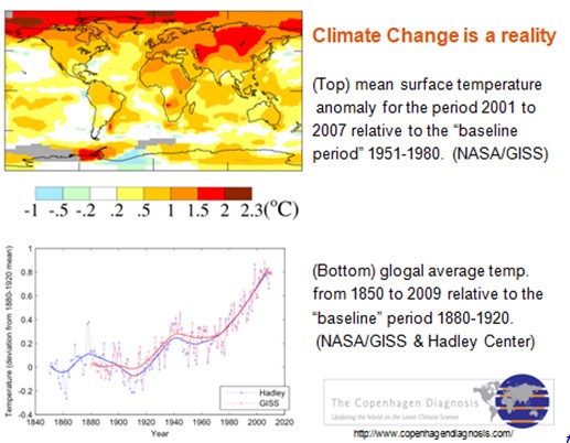
Figure 1 : (top) Mean surface temperature anomaly/change (°C) for the period 2001 to 2007 relative to the “baseline period” 1951 to 1980; map estimates are based on NASA Goddard Institute for Space Studies (GISS) data and (bottom) global average temperature from 1850 to 2009 relative to the “baseline period” 1880 to 1920 estimated from NASA/GISS and Hadley Centre for Climate Prediction and Research data. Figure taken from The Copenhagen Diagnosis, 2009 (4).
As many basic elements of human society and the environment are sensitive to climate variability and change it is to be expected that climate change/global warming will have significant socioeconomic and environmental effects/impacts (e.g., water resources, land use/agriculture, vulnerability to extreme events, coastal areas, ecosystems, human health,…). However, the extent of climate change effects/impacts will vary by region, over time and according to the vulnerability and adaptability of different societal and environmental systems.
Socioeconomic and environmental effects/impacts of climate change can be divided into current changes/impacts and probable projected changes/impacts for the future. These are discussed by (3) with more recent updates given in (4). The currently observed effects are expected to continue and amplify further, as most of the processes induced by global warming have a tendency to accentuate it.
Natural hazards-related disasters worldwide, but most notably in the developing world, have claimed many lives, injured many more, led to massive population displacement, caused severe damage to the natural and built environment, and seriously undermine efforts for achieving sustainable economic and social development. According to data and analysis by Munich Re (5), over the past decades there has been an upward trend in the number of natural disasters and related losses as a result of such factors as population growth, concentration of population in and industrialization of exposed, hazard/disaster prone areas, environmental degradation and, possibly, climate change.
Indeed, the potential future effects of global climate change include more frequent wildfires, more intense heat-waves, longer periods of drought in some regions and a projected increase in the frequency, duration and intensity of severe climatic/weather hazard events such as tropical storms and thus a likely increase in the number and scale of related disasters. In fact, the intensity and frequency of weather related hazard events has increased in many regions and there is mounting evidence that climate change is a factor (6, 7, 8).
Various sources (e.g., UNISPACE III (9), IGOs and NGOs,..) have noted that information derived from space-based technologies can be combined with other relevant geospatial data/information in a Geographic Information System (GIS) to provide insight and significant solutions to problems in such strongly linked areas of work as: addressing climate change, hazard/disaster risk reduction/management, human security, natural resources management, monitoring and protecting the environment, poverty reduction, public health, education, capacity building, and international development.
Remote sensing satellites, used to monitor land surface, oceans and the atmosphere, offer numerous advantages such as global coverage, repetitiveness, speed of data acquisition and consistency of collected data. Earth satellite imagery plays an important role in understanding what is currently happening and at what pace. GIS offer an integrated approach to storing, retrieving, manipulating, analyzing, integrating, displaying, comparing and interpreting spatially related sets of digital data from a variety of sources.
As an example of application, the use of RS EOS imagery and GIS technologies allows environmental scientists and local communities to assess and understand environmental changes/impacts linked to climate change as well as show the extent of human impact on the environment and to better prepare and evaluate adaptation strategies. In illustration of this, Figure 2 shows two Landsat Images of Mount Kilimanjaro in Tanzania, taken at the same season in 1976 and 2000, showing the shrinking snow cap. Kilimanjaro’s eternal snows have lost 82% of their surface since 1900. Satellites measure the snow cover at the summit of this 5895m high volcano at regular intervals.
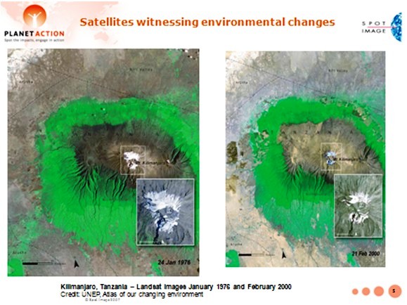
Figure 2 : Two Landsat images of Mount Kilimanjaro, Tanzania, taken in 1976 and 2000, showing the shrinking snow cap. Credit: UNEP.
Faced with the climate change crisis, and the human and environmental impact, there is an urgent need to take action to improve our understanding of climate change causes, better address current climate change impact assessment, contribute to reducing uncertainties in model projections as well as assess vulnerabilities to hazard-related disaster risks, and develop and implement comprehensive climate change mitigation and adaptation measures as well as comprehensive multihazard-related disaster risk reduction strategies.
Within the linked sectors of activity listed earlier there is an increasing need for readily accessible space technology data and information, along with the knowledge and tools required for analysis. Especially needed are value-added visual data analysis (“visualizations”) of different areas at different scales worldwide and GIS products addressing the needs of areas under consideration for more informed climate change mitigation and adaptation as well as disaster risk management-related planning, policy and decision-making.
It has also been noted that keys to the effective use of space, geo-information/GIS and other relevant technology applications for addressing socioeconomic and environmental impact issues include awareness raising, transfer of knowledge, and capacity building. Especially needed are educational and training initiatives, both traditional classroom and web-based e-learning with inclusion of case studies, for the use of such technologies (e.g., 10, 11, 12).
As noted by several sources (e.g., 3, 6, 7, 8, 13, 14, 15, 16) there is an increased awareness/recognition that the climate change mitigation and adaptation (CCMA) and disaster risk reduction/management (DRRM) communities are closely linked. Indeed, climate change increases disaster risk through processes like temperature and sea-level rise, changing precipitation patterns, rapidly expanding coastal cities and likely/projected increase in the frequency and/or severity of weather and climate hazard events with simultaneous increase in societal vulnerability to natural hazards.
The Planet Action (PA) Initiative: Earth Observation and GIS communities tackling the climate crisis
In response to international communities needs and the preoccupying climate change situation, Planet Action (hereafter PA) was launched in June 2007 by Spot Image as a non-for-profit collaborative “corporate citizenship initiative” to encourage the Earth observation and GIS professional communities to help NGOs, large organizations, local institutions and universities/research centers deal with issues in relation with climate change and encourage action in a new cooperative approach.
The PA vision or broad objective consists in tackling climate change at a local scale for a global benefit, using Earth observation and GIS technologies. This vision was largely motivated by the belief that, faced with the climate change emergency and its negative impacts, the Earth observation and geo-information/GIS industries have a strong potential to help (scientifically and practically) and should take action thanks to: 1) extensive earth observation means/technologies and services; 2) vast archives of data/images in various resolutions and from various sources(optical and radar satellites, airborne images, …) accumulated over 20 years (with more than 20 million images) for SPOT and 25 years for Landsat, time-series data,…; 3) extensive experience in analyzing and understanding Earth imagery; 4) GIS software and dynamic users’ networks; 5) a worldwide network of partner operators and receiving stations, as well as a large network of scientists, scholars and educators.
One can list three PA core objectives: 1) build capacity to understand and act upon climate change related issues and to support any local project, big or small, whether from scientific or civil societies, engaged in research and action addressing climate change causes, vulnerability, mitigation, impacts, adaptive solutions/measures and related hazard/disaster risk reduction/management for a global benefit; 2) to support cooperation within and between project teams, local communities, global organizations and to use Earth imagery and GIS as a link between these communities; 3) to raise the awareness of/educate any individual or community about climate change, the benefits of Earth observation imagery, derived geospatial information and GIS technologies, and the role of local NGOs, scientists and educators as they handle these issues.
Current actions of PA related to these core objectives include: 1) Active and ongoing support to local projects that meet the PA criteria (see below) by providing expertise and donating remote sensing data/images from different EOS (SPOT constellation, Formosat-2, Quickbird,...) to relevant organizations. PA partners (co-founder ESRI, ITT, Trimble) donate GIS and image processing tools; 2) acting as a climate change information and knowledge exchange platform, fostering cooperation between implicated communities, through the PA website (www.planet-action.org) a common depository of knowledge generated around the projects (case studies) and the expected feedback; 3) awareness raising through global education and outreach programmes supported by the PA projects and website. Projects supported by PA represent non-profit organizations worldwide and are a formidable source of rich content (each project “tells a story”); this content can be adapted to any background/level/age and told in schools (including to schoolchildren), associations or institutions.
Since its inception, PA has been joined by many contributing, project and outreach partners (PA also has an Ambassador, explorer Stéphane Lévin). Founding contributing partner Spot Image (a company created in 1982 by the French Space Agency CNES, currently owned by Astrium Services, an EADS company, and other European partners) is a world leader in the distribution of space-sourced geographic information products, services and solutions and is the commercial operator for the SPOT Earth observation satellites (see Figure 3). Co-founder ESRI is a leading GIS technologies provider. Other contributing partners include ITT, Trimble, NSPO, Digital Globe, CRISP, ITU, ESA and UNESCO.
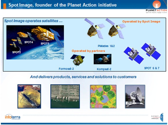
Figure 3 : Spot Image activities.
PA is currently supporting almost 400 projects worldwide (as illustrated in Figure 4). Projects investigate and assess climate change related issues in one or more of the following PA domains (fields of activity): Awareness, Biodiversity and Conservation, Drought and Desertification, Forest and Deforestation, Ice and Snow, Human Issues, Oceans and Coastlines, Water Resources.
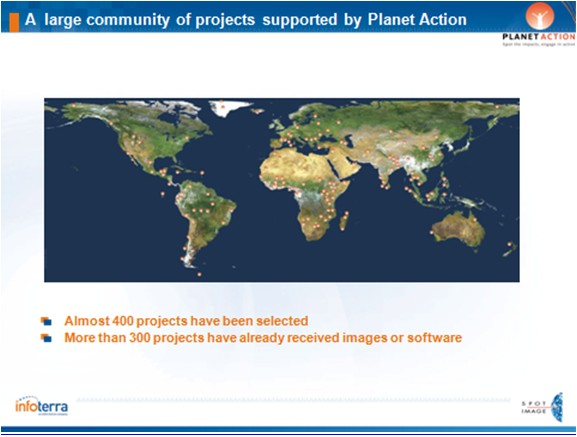
Figure 4 : Projects supported by Planet action are located on all continents and address a wide variety of topics.
NGOs, institutions and research laboratories engaged in action addressing climate change issues can submit their projects through the PA website using the on-line form. Projects should comply to the following eligibility criteria: - assess climate change related issues and propose a course of actions; - deal with at least one of the PA focus areas (currently eight); - have a member who resides in the country where the project takes place (at least for the project duration); - be proposed by a non-profit organization such as a NGO, a public laboratory or a university (business organizations do not qualify for direct support); - confirm that the project has no commercial objective; - confirm that the project has no religious or ideological content or objective. Additional criteria may be considered such as: - the importance and usefulness of the project for local populations; - a focus on building awareness, information, training or outreach activities that will result from the project; - specific methodologies supported by staff members or associated teams with an appropriate background for the work proposed.
PA then reviews and validates each proposal. Proposals which are accepted (validated) can then receive imagery and software. A typical PA project may require 5 to 10 satellite images per year-which may be provided either at once, or at different periods of time, as requested. Imagery may also have been acquired by different satellites, thus offering different characteristics (resolution, …). Once a project is validated, the Project Leader is commited to provide regular and formal feedback (posted on the PA website) for sharing of information/knowledge. For the interested reader, complete information on project submission is available at the PA website (www.planet-action.org).
Examples of supported projects / case studies
In a transfer of knowledge effort and as case studies examples for those readers who may be interested in submitting one or more proposals to PA, four selected projects having received support from PA are briefly presented below. The reader interested in obtaining more details on these and other projects is invited to visit the PA website.
Pan-Tropical mapping of forest cover project in Uganda (WHRC, UN-REDD Programme). PA domain: Forest & Deforestation.
This project is illustrated and summarized in Figure 5.
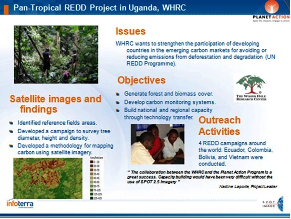
Figure 5 : Pan-Tropical mapping of forest cover project in Uganda (WHRC, UN-REDD Programme). PA domain: Forest & Deforestation.
The UN Programme for Reducing Emissions from Deforestation and forest Degradation (REDD) is a key issue as deforestation,particularly in tropical regions, is responsible for about 20% of global CO2 emissions.
The Woods Hole Research Center (WHRC) is a leading expert in forestry and has developed a method using satellite images to assess the biomass of forests (production of biomass/carbon maps) for improved forest management (including REDD). The outreach activities they ensure consist in explaining this method to populations (build national and regional capacity through technology transfer).Complete information on the REDD Programme is available at http://www.un-redd.org/
Reducing flood risks in the Philippines (GTZ). PA domain: Human issues.
The project is summarized in Figure 6.
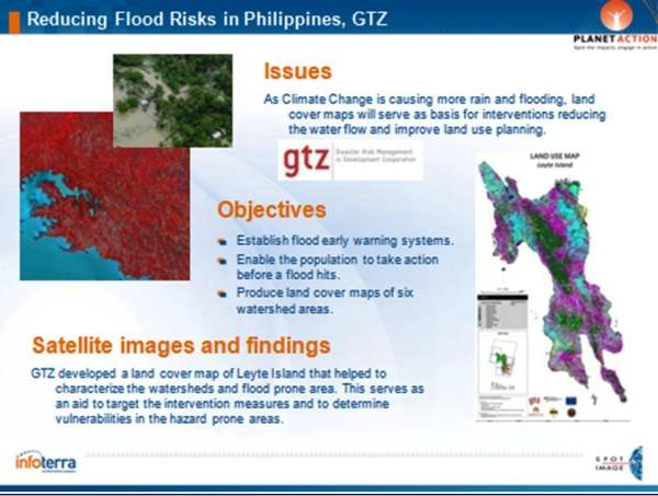
Figure 6 : Reducing flood risks in the Philippines (GTZ). PA domain: Human issues.
This project, which was discussed in a plenary presentation during the Fourth United Nations International UN-SPIDER Bonn Workshop (these Proceedings) (17), is highly technical and humanitarian at the same time. It involved the development of an early warning system that is currently under review with local government agencies and could save thousands of lives.
GTZ uses land cover maps of watershed areas in the Eastern Visayas, produced/updated by utilizing SPOT satellite images, to reduce the risk of flooding disasters.
Coral reef bleaching, Guadeloupe. PA domain: Oceans & Coast Lines and Biodiversity & Conservation.
The project is summarized in Figure 7.
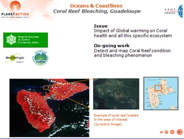
Figure 7 : Coral reef bleaching, Guadeloupe. PA domain: Oceans & Coast Lines and Biodiversity & Conservation.
Coral reefs provide direct benefits to human populations in tropical and subtropical coastal zones (e.g., sustain fisheries, provide protection from storm surges).Rising ocean temperature is a key factor behind increasingly frequent coral bleaching episodes. Also, rising CO2 levels affect ocean chemistry limit coral growth and its ability to recover from stresses like coral bleaching, which may lead to their death.
This may contribute to increasing the vulnerability of island nations.
Objectives of this project include the detection and mapping of coral reef condition and bleaching, as well as taking action to reduce human impacts on coral reef.
Glacial lake outburst flood (GLOF) risk assessment, Nepal (ICIMOD). PA domain: Human Issues.
The project is summarized in Figure 8.
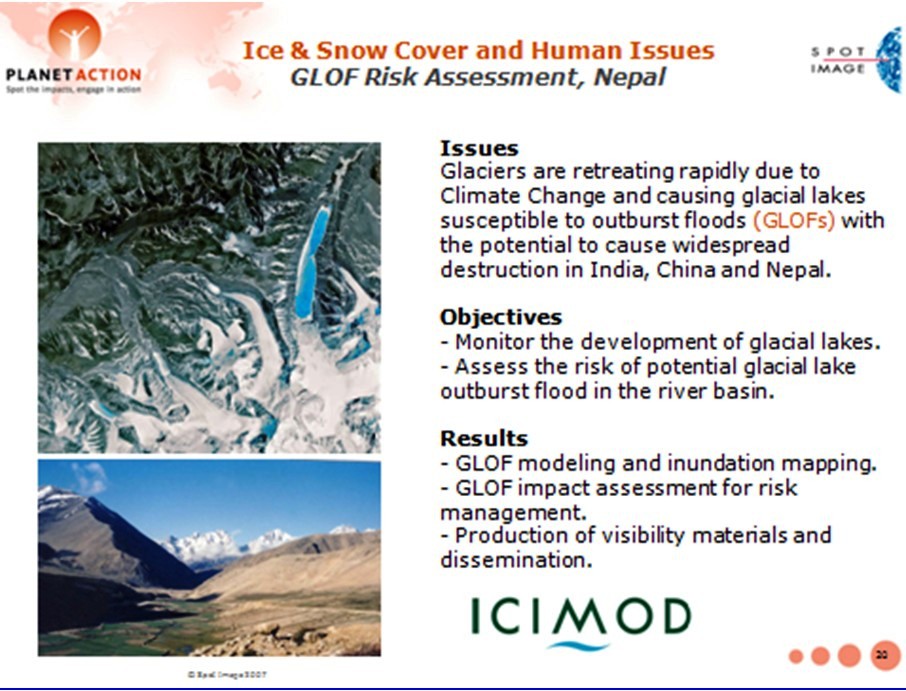
Figure 8 : Glacial lake outburst flood (GLOF) risk assessment, Nepal (ICIMOD). PA domain: Human Issues.
The globally observed retreat of glaciers is an example where climate change may lead to new threat levels, with the accumulation of water in natural moraine dams as a result of glacial melt potentially leading to glacial lake outburst floods (so-called GLOFs). With destructive down-stream effects, GLOF events can have serious impacts on the infrastructure, lives and livelihoods of mountain communities, with far-reaching socio-economic consequences.Many lakes in the Himalayas are categorized as potentially dangerous.
Objectives of this project were to monitor the growth of glacial lakes using high resolution SPOT imagery and manage GLOF risks to which populations are exposed. The project included an awareness-raising and training campain.
Examples of education- and outreach activities
In this section two representative PA educational and outreach activities are presented.
PA exhibit at the Cité de l’Espace, space science park in Toulouse.
As shown in Figure 9, PA has partnered with the Cité de l’Espace in Toulouse, a first rate science museum, to exhibit 20 projects which illustrate the use of satellite imagery and GIS technology in combating the climate change crisis.
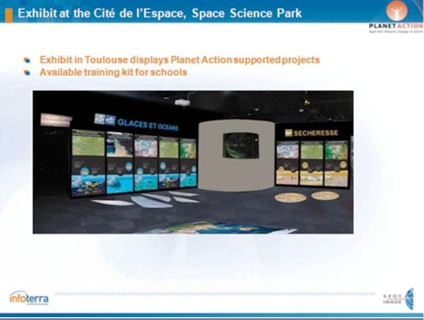
Figure 9 : PA exhibit at the Cité de l’Espace, space science park in Toulouse.
Developing awareness on the Green Belt Movement in Kenya.
PA and explorer Stéphane Lévin met with the Geen Belt Movement (GBM) for awareness action on climate change adaptation in Kenya (Figure 10). Indeed, the GBM, led by Wangari Maathai, the Nobel Prize for Peace in 2004, is pursuing a reforestation plan and has planted 40 million trees in Kenya since its foundation, demonstrating the bebefits of this type of action to local populations. The GBM turned to PA to help it better protect and monitor Kenya’s forests, and to plan reforestation strategies.
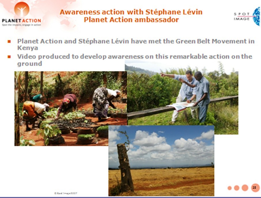
Figure 10 : Developing awareness on the Green Belt Movement in Kenya.
Conclusions
The PA Programme brings useful support (RS EOS imagery, GIS, expertise) to local projects, big & small, dealing with climate change issues (causes, mitigation, vulnerability, impact assessment, adaptation) and associated multihazard-related disaster risk reduction & management (DRRM).
In the context of the global climate change emergency and projected increases in the number and scale of hydro-meteorological hazard events and related disasters, PA offers a means of addressing several of the urgent needs related to the CCMA and DRRM sectors of activity (and also to poverty reduction and development) as discussed in Section 1 of this work.
PA has been joined numerous partners and has already provided support to a large number of projects worldwide, with substantial socioeconomic and environmental benefits.
Indeed, evaluation of PA project-related activities has demonstrated that the Programme works and creates value for all the partners involved. Especially appreciated by concerned communities and users is project/case study feedback with posting of results on the PA website.
PA will be supporting additional projets this year and will be following up on current projects. Education/outreach activities may be expanded (consider e-learning?) with new partners always welcome. PA will also continue to support communication, coordination and cooperation within and between project teams, local communities and global organizations using satellite imagery and GIS as well as the sharing of information/knowledge and experiences as a link. In particular, an important goal would be to contribute to the development of coordinated efforts between the closely linked CCMA and DRRM communities. Finally, PA may consider sharing a number of its projects/case studies with UN-SPIDER, for potential inclusion within the UN-SPIDER Communication and Information Platform (Web based Knowledge Portal).
Acknowledgments
The author wishes to thank the Planet Action team in Toulouse, in particular Patricia Dankha and Isabel Ortega, for their help and suggestions which were very useful in the completion of this work. The author is also grateful to Robert Backhaus, Natalie Epler and Ashley Lin of the UN-SPIDER Office in Bonn for their kind advice and support.
References
- IPCC, 2007: Climate Change 2007: The Synthesis Report: Summary for Policymakers. Contribution of Working Group I (WGI) to the Fourth Assessment Report of the Intergovernmental Panel on Climate Change (2007).
- IPCC, 2007: Climate Change 2007: The Physical Science Basis. Contribution of Working Group I (WGI) to the Fourth Assessment Report of the Intergovernmental Panel on Climate Change (2007).
- IPCC, 2007: Climate Change 2007: Impacts, Adaptation, and Vulnerability. Contribution of Working Group II (WGII) to the Fourth Assessment Report of the Intergovernmental Panel on Climate Change [M. Parry, O. Canziani, J.P. Palutikof, P. van der Linden, and C. Hanson (eds.)]. Cambridge University Press, Cambridge, United Kingdom, 1000 pp. (2007).
- I. Allison et al., The Copenhagen Diagnosis, 2009: Updating the World on the Latest Climate Science, The University of New South Wales Climate Change Research Centre (CCRC), Sydney, Australia, 60pp. (2009).
- Münchener Rückversicherung-Gesellschaft (Munich Re), GeoRisks Research Dept., Nat Cat Service, (2010).
- F. Sperling and F. Szekely, “Disaster Risk Management in a Changing Climate”, discussion paper prepared for the World Conference on Disaster Reduction on behalf of the Vulnerability and Adaptation Resource Group (VARG), Report with addendum on conference outcomes, Washington, DC (2005).
- International Strategy for Disaster Reduction (ISDR), Global Assessment Report on Disaster Risk Reduction: Risk and Poverty in a Changing Climate, 207 pp. United Nations, Geneva, Switzerland (2009).
- International Strategy for Disaster Reduction (ISDR), Disaster Risk and Climate Change, 2pp. , Geneva, Switzerland, (2008).
- Report of the Third United Nations Conference on the Exploration and Peaceful Uses of Outer Space, UNISPACE III, Vienna, Austria, (1999).
- A. Kucinskas and D. Seber, Geo-Information and Space Technologies-Based Geohazards-Related Disaster Management Support System, EGU General Assembly, Published on CD-ROM, Vienna, Austria, (2007).
- A. Kucinskas and D. Seber, An Interactive, Integrated Education and Training Information System for Natural Multihazard-Related Disaster Management, EGU General Assembly, Published on CD-ROM, Vienna, Austria, (2008).
- A. Kucinskas and B. Tomaszewski, Towards an Interactive Educational Environment for Disaster Management Support (IEEDM Project), Plenary Presentation, Third United Nations International UN-SPIDER Bonn Workshop, Bonn, Germany, (2009).
- International Strategy for Disaster Reduction (ISDR), Briefing Note 01: “Climate Change and Disaster Risk Reduction”, Geneva, Switzerland. (2008).
- K. O’Brien et al., Disaster Risk Reduction, Climate Change Adaptation and Human Security, Report Prepared for the Royal Norwegian Ministry of Foreign Affairs by the Global Environmental Change and Human Security (GECHS) Project, GECHS Report 2008:3, (2008).
- United Nations Framework Convention on Climate Change (UNFCCC), Climate Change: Impacts, Vulnerabilities and Adaptation in Developing Countries, 68pp. Bonn, Germany, (2007).
- L. Biukoto (SOPAC) Big Ocean, Small Islands: Building Resilience of Pacific Island Communities, Plenary Presentation, United Nations International UN-SPIDER Workshop: “Building Capacities to Reduce Disasters”, SIDS, Climate Change and Risk Reduction in the Pacific Region, Vienna, Austria, 2-4 June 2009. (2009).
- O. Neussner, (GTZ), Deriving Risk Maps from Satellite-Based Land Use Maps in the Philippines, Plenary Presentation, Fourth United Nations International UN-SPIDER Bonn Workshop, Bonn, Germany, These Proceedings, (2010).
* At the time of writing Spot Image, now Astrium GEO-information Services.