The Copernicus Emergency Management Service (EMS) - Mapping and the International Charter Space and Major Disasters have been activated as Hurricane Irma makes landfall on the islands of the north-east Caribbean.
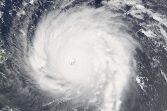
Hurricane Irma developed from a tropical storm to a powerful Category 5 storm, the highest on the Saffir-Simpson Hurricane Scale, and is the most powerful Atlantic Ocean hurricane in recorded history outside of the Gulf of Mexico or north of the Carribean. The expected wind speed for such a hurricane is of at least 252 kilometer per hour. It is predicted to follow a path affecting the region from the Lesser Antilles to the United States, with unusually widespread winds that can extend to 85 km for hurricane force winds and up to 295km for tropical-storm force winds.
UNITAR-UNOSAT requested the activation of the Charter for the western part of the Caribbean on behalf of UN Disaster Assessment and Coordination (UNDAC), while the National Emergency Commission of the Dominican Republic requested the activation of the Charter for the country, with the project management assumed by Oxfam.
UpdateCopernicus EMS-Mapping has now four running activations for Hurricane Irma, which are all listed below separately. In addition, links to all maps produced through the activations are listed in a spreadsheet contributed by a user.
The International Charter Space and Major Disasters also has four running activations, which are all listed below.
- Copernicus EMS - Mapping activation EMSR236: Hurricane Irma in British Virgin Islands
- Copernicus EMS - Mapping activation EMSR234: Hurricane Irma in Sint Maarten
- Copernicus EMS - Mapping activation EMSR233: Hurricane Irma in Haiti and Dominican Republic
- Copernicus EMS - Mapping activation EMSR232: Hurricane Irma in Antilles Islands
- Spreadsheet listing all maps produced under the CopernicusEMS activations above
- Charter activation - Hurricane Irma in Carribean
- Charter activation - Hurricane Irma in the Dominican Republic
- Charter activation - Hurricane Irma in the United States
- Charter activation - Hurricane Irma in Haiti