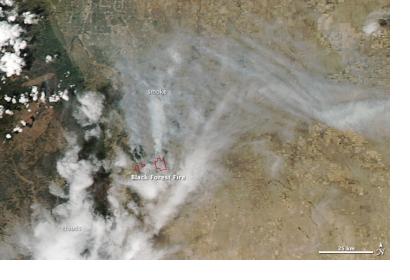
NASA's Terra and Aqua satellites with their Moderate Resolution Imaging Spectroradiometer (MODIS) sensors captured Black Forest fires in Colorado on June 12, 2013, as NASA reported on their website.
"When the National Interagency Fire Center released its 2013 wildfire outlook in early June, it did not forecast unusually high fire risk for Colorado. Most of the Rockies received some relief from drought during the spring, so there was hope that this year’s fire season would be more manageable than the last. But then the heat arrived. Temperatures soared above 100°F (38 °C) in Denver on June 11, the earliest it has ever reached triple digits. That heat, along with gusty winds and drought-parched forests, came together to produce the Black Forest fire, the most destructive the state has ever seen. By the afternoon of June 13, the fire had destroyed 360 homes and damaged 14 others. The Waldo Canyon fire, Colorado’s most destructive prior to the Black Forest fire, destroyed 346 homes."
MODIS captured this image of the fire about 20 miles (30 kilometers) northeast of Colorado Springs. Red outlines indicate hot spots where MODIS detected the unusually warm surface temperatures associated with fires.

