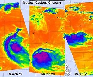
Three days of NASA infrared satellite imagery provides a clear picture to forecasters of the effect wind shear has had on former Cyclone Cherono. Wind shear increased near Cyclone Cherono this weekend and weakened it down to a remnant low pressure area in the Southern Indian Ocean. Cherono's remnants have moved away from Mauritius and still causing ocean swells.
NASA's Aqua satellite flew over former Tropical Cyclone Cherono each day over the last three days and the Atmospheric Infrared Sounder (AIRS) instrument captured the effects of the increased wind shear in infrared imagery. Over this past weekend, vertical wind shear increased battering the structure of Cyclone Cherono and weakening the circulation. Now the remnant low continues to move away from Mauritius and is expected to dissipate over the next day or two.