What is Sentinel map Earth slow surface warping?
The focus of interest is how tectonic strain is building up along the North and East Anatolian Faults - the trigger points for so many damaging quakes in the past. British researchers are now routinely mapping a great swath of Earth's surface, looking for the subtle warping that ultimately leads to quakes. The team is processing satellite images to show how rocks in a belt that stretches from Europe's Alps to China are slowly accumulating strain. Movements on the scale of just millimetres per year are being sought. The new maps are being made available to help researchers produce more robust assessments of seismic hazard. The kind of change they are trying to chart is not noticeable in the everyday human sense, but over time will put faults under such pressure that they eventually rupture - often with catastrophic consequences.
Summary of applications of Sentinel surface warping data
The NERC Centre for the Observation and Modelling of Earthquakes, Volcanoes and Tectonics (COMET) aims to understand tectonic and volcanic processes and hazards through the integrated application of Earth Observation (EO) data, ground-based measurements, and geophysical models. COMET provides National Capability science and expertise in EO and geohazards that underpins a broad range of world-leading research. Environmental Hazards are one of the key societal challenges in NERC’s new strategy. More than 800,000 people have died in earthquakes since the turn of the century; volcanic eruptions have demonstrated their power to cause major disruption to modern society. The UK invests considerable resources via ESA and the UK Space Agency in developing and launching Earth Observation Satellites. The data sets produced by these missions have the potential to make a major impact in geohazard mitigation and research, but missions are conceived, designed and operated on time scales that are far longer than individual responsive-mode grants. A stable, long-term funding platform enables COMET scientists to influence the design and operational program of EO missions and maximises the benefits of the up-front investment in EO infrastructure. COMET scientists are at the forefront of the development and exploitation of EO data for high-impact geohazards research. For earthquakes and tectonics, the key scientific challenges being addressed by COMET during 2014-2019 are: (1) What are the distribution of tectonic strain and seismic hazard in the continents? (2) How does seismic hazard vary in space and time following major earthquakes? (3) What is the mechanical structure of continental lithosphere? The challenges in volcanology are (4) What are the patterns in volcanic deformation and degassing on global and regional scales and how do these relate to the distribution of global volcanic hazard? (5) How does hazard vary in space and time during periods of volcanic activity? (6) How do we generalise models of subsurface processes to understand variations in volcanic behaviour? In addition, COMET scientists are developing new instruments and missions. A new partnership between COMET and the NERC British Geological Survey (BGS) enables us to build on our cutting-edge research to deliver high-impact monitoring services.
Sample Application
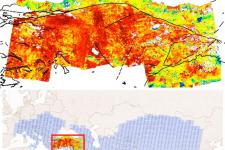
As a proof of principle - and to give an example of what the new system can do - the COMET group showed off its maps of Turkey at AGU.
These capture the 20-25mm/year westwards march of the Anatolian plateau relative to Eurasia.
The focus of interest is how tectonic strain is building up along the North and East Anatolian Faults - the trigger points for so many damaging quakes in the past.
Anticipated Services
Dr Walters is affiliated to the UK Centre for Observation and Modelling of Earthquakes, Volcanoes and Tectonics (COMET).
He announced the start of the new service here in San Francisco, at the Fall Meeting of the American Geophysical Union.
The key to the UK scientists' work is the high performance of the EU's new Sentinel-1 radar satellites.
This pair of spacecraft repeatedly and rapidly images the surface of the globe, throwing their data to the ground using a high-speed laser link. And by comparing whole stacks of their pictures in a technique known as interferometry, the COMET group can begin to see the very slow bending and buckling that occurs in the crust as a result of shifting tectonic plates.
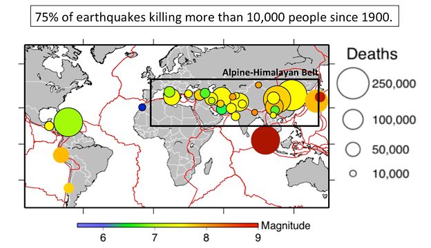
To initiate the service, the researchers are concentrating on the Alpine-Himalayan seismic belt.
This is the sector where most of the deaths arising from big earthquakes occur.
In time, however, the mapping exercise will be extended to cover all major seismic hazard zones, including the rim of the Pacific basin - the so-called "ring of fire", where large tremors are also a regular occurrence.
3D visualization of Earthquakes with magnitude greater than 6 since January, 1, 2000