A type of volcanic event near an opening/vent in the Earth’s surface including volcanic eruptions of lava, ash, hot vapour, gas, and pyroclastic material (IRDR Glossary).
The majority of volcanoes in the world form along the boundaries of Earth's tectonic plates. When tectonic plates collide, one often plunges deep below the other in what's known as a subduction zone. Not all volcanoes are related to subduction: another way volcanoes can form is what's known as hotspot volcanism. In this situation, a zone of magmatic activity—or a hotspot—in the middle of a tectonic plate can push up through the crust to form a volcano. Although the hotspot itself is thought to be largely stationary, the tectonic plates continue their slow march, building a line of volcanoes or islands on the surface (National Geographic).
A volcano is currently active if it is erupting lava, releasing gas or generating seismic activity. An active volcano is labelled dormant if it has not erupted for a long time but could erupt again in the future. When a volcano has been dormant for more than 10 000 years, it is considered extinct. Volcanoes can remain inactive, or dormant, for hundreds or thousands of years before erupting again. During this time, they can become covered by vegetation, making them difficult to identify.
How explosive a volcanic eruption is depends on how easily magma can flow or trap gas. If magma is able to trap a large amount of gas, it can produce explosive eruptions. (Australian Government).
Facts and figures
Over the last 11,500 years, more than 1,500 major eruptions have occurred, with approximately 500 in the Pacific "Ring of Fire" alone (PreventionWeb).
There are volcanoes on every continent, even Antarctica. Some 1,500 volcanoes are still considered potentially active around the world today; 161 of those—over 10 percent—sit within the boundaries of the United States (National Geographic).
There are different types of eruptive events. We can distinguish between primary and secondary events.
Primary events are:
Pyroclastic explosions
Hot ash releases
Lava flows
Gas emissions
Glowing avalanches (gas and ash releases)
Secondary events are:
Melting ice, snow and rain accompanying eruptions are likely to provoke floods and hot mudflows (or lahars)
Volcanoes can have many different appearances. The shape of a volcano provides clues to the type and size of eruption that occurred. Eruption types and sizes depend on what the magma is made up of. Three common volcano forms are:
Shield volcano: have a broad, flattened dome-like shape created by layers of hot and runny lava flowing over its surface and cooling.
Composite volcano : also known as stratovolcanoes, they are formed from explosive eruptions. These eruptions create steep sided cones.
Caldera volcano: these volcanoes erupt so explosively that little material builds up near the vent. Eruptions partly or entirely empty the underlying magma chamber which leaves the region around the vent unsupported, causing it to sink or collapse under its own weight. The resulting basin-shaped depression is roughly circular and is usually several kilometres or more in diameter (Australian Government).
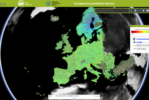
Subsidence processes, sinkholes, or landslides can cause many problems. Even minor subsidence can weaken buildings and infrastructure and lead to issues such as flooding, and in worst cases abrupt disappearance of sections of land. Monitoring and predicting such processes are essential for adopting mitigating strategies.
The new European Ground Motion Service, created and offered by the Copernicus Land Monitoring Service and implemented by the European Environment Agency, provides free and accessible ground motion data.
Based on radar data from Copernicus Sentinel-1 satellite mission, the service provides information on the motion of land, structures and infrastructure in Copernicus Participating States. Its aim is to give users reliable information on ground motion at a local, regional or national scale.
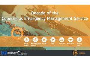
Implementing science to save lives: A Decade of the Copernicus Emergency Management Service
The Copernicus Emergency Management Service (CEMS) celebrates a decade of operation as a world leader in emergency mapping, early warning tools and open-access disaster information.
For the past ten years, CEMS has provided a global service as a fully operation emergency mapping service at no cost to users and with open access data.
Some highlights on the contribution of CEMS in global disaster risk management activities:
576 Rapid Mapping Activations with 5,500+ maps delivered
Designed and implemented the world’s first Global Flood Monitoring tool
Ten years of wildfire forecasts up to ten days into the future
Average of 200+ flood and 500+ flash flood notifications to Member States and authorised users each year
Offers a current and historical database of 7,000+ drought episodes since 1950
NASA is launching a prototype instrument that could make monitoring volcanic activity and air quality easier. The “Nanosat Atmospheric Chemistry Hyperspectral Observation System,” or NACHOS, will use a compact hyperspectral imager to locate sources of trace gases in areas as small as 0.4 square kilometers.
NACHOS is part of Northrop Grumman’s 17th resupply mission to the International Space Station and will remain aboard Northrop Grumman’s Cygnus spacecraft until May 2022, when the spacecraft will unberth from the International Space Station and place NACHOS in low-Earth orbit before the cargo spacecraft reenters Earth’s atmosphere.
If successful, the system will be the smallest, highest resolution space-based instrument dedicated to monitoring atmospheric trace gases like sulfur dioxide (SO2) and nitrogen dioxide, paving the way for future Earth-observing systems that will not…
The scale of a recent volcano eruption took the people of Tonga by surprise. Scientists monitoring the submarine volcano, Hunga Tonga-Hunga Ha'apai, were likewise caught off-guard, failing to foresee an explosion which would unleash a Pacific-wide tsunami.
The scale of the eruption was hailed as a “once in a millenium” event by one scientist. It hurled gasses and ash over 39km into the atmosphere – comparable to that ejected from Mount Pinatubo in 1991 – and generated a…
On the 13th and 15th of January 2022 the underwater volcano on Hunga Tonga-Hunga Ha’pai, located in the South Pacific Kingdom of Tonga erupted. The eruption on the 15th of January 2022 was seven times more powerful than the first eruption of the volcano, which took place on the 20th of December 2021. Additionally, it led to a tidal gauge, resulting in a tsunami wave that impacted countries in the Pacific Ocean, from the Kingdom of Tonga, Australia and New Zealand, Japan, up to Peru, among others, on the other side of the Pacific.
The volcanic eruption was captured by the GOES-West Earth-observing satellite operated by the U.S. National Oceanic and Atmospheric Administration (NOAA), as well as by the Himawari-8 satellite, operated by the Japan Meteorological Agency (JMA), resulting in spectacular images, revealing the large extent of this event.
This is an example of the capacity of geostationary satellites and the benefit of meteorological satellites tracking large…
Space-based Solutions for Disaster Risk Management and Emergency Response for Southern Africa
UN-SPIDER and ZFL are holding a regional virtual expert meeting for Southern Africa, a region vulnerable to hydrometeorological, geological, coastal and biological hazards and gravely impacted by droughts in recent years.
The objectives of this regional virtual expert meeting are:
To raise awareness regarding novel applications of satellite technologies in risk assessment, early warning systems, and disaster response operations;
To survey and examine efforts carried out by risk and disaster management institutions in Southern African countries on the use of space technologies and space-based information in disaster risk management, preparedness, response and recovery efforts;
To explore ways to enhance the use space technologies in disaster risk management and response and recovery applications in Southern Africa.…
The Copernicus DEM is a Digital Surface Model (DSM) which represents the surface of the Earth including buildings, infrastructure, and vegetation. The Copernicus DEM is provided in 3 different instances. Two worldwide coverages at 90m (GLO-90) and 30m (GLO-30) resolution are openly available to the public for download via the PANDA Catalogue and FTP. A further European coverage (EEA-10) is provided at 10m resolution, but data is restricted to eligible users who meet required access rights.
The Copernicus DEM is a Digital Surface Model (DSM) which represents the surface of the Earth including buildings, infrastructure, and vegetation. The Copernicus DEM is provided in 3 different instances. Two worldwide coverages at 90m (GLO-90) and 30m (GLO-30) resolution are openly available to the public for download via the PANDA Catalogue and FTP. A further European coverage (EEA-10) is provided at 10m resolution, but data is restricted to eligible users who meet required access rights.
 on the Landsat 8 satellite acquired this top image of Mount Etna on December 28, 2018. The image highlights the active vent and thermal infrared signature from lava flows, which can be seen near the newly formed fissure on the southeastern side of the volcano. The image was created with data from OLI (bands 4-3-2) and the Thermal Infrared Sensor (TIRS) on Landsat 8. Image: NASA.")
 Publishing institution:
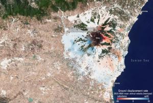


")

 The Copernicus DEM is a Digital Surface Model (DSM) which represents the surface of the Earth including buildings, infrastructure, and vegetation. The Copernicus DEM is provided in 3 different instances. Two worldwide coverages at 90m (GLO-90) and 30m (GLO-30) resolution are openly available to the public for download via the PANDA Catalogue and FTP. A further European coverage (EEA-10) is provided at 10m resolution, but data is restricted to eligible users who meet required access rights.Publishing institution: