United Kingdom of Great Britain and Northern Ireland

country taxonomy block

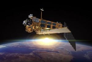
The Indian Space Research Organization (ISRO) launched two Earth observation satellites on 16 September from Sriharikota where the Satish Dhawan Space Center is located. NovaSAR S1-4, which were developed in and will be operated from the United Kingdom, will provide Earth observation data, including for disaster and risk management.

The satellites were constructed by Surrey Satellite Technology Limited, a UK-based company that, in partnership with ISRO (the vehicle was developed by Vikram Sarabhai Space Center), has made possible the commercial PSLV-C42 mission to launch the satellite. This is not the only foreign satellite launched by ISRO. Since 1999, the space organization has released several devices from international…

more
Publishing date 21/09/2018

Last 16 of July the UK Space Agency (UKSA) and the South African Space Agency (SANSA) signed a Memorandum of Understanding (MoU) to increase collaboration in scientific projects related to space.

Both institutions will share infrastructure and knowledge in fields including applications for weather monitoring, climate change and satellite information. Areas covered in this document include making UKSA satellite data accessible to SADC users and SANSA being access point for NovaSar data in South Africa.

"I am delighted to sign this MoU on behalf of the UK Space Agency, which reflects the growing strength in collaboration in cutting edge science between our two countries. South Africa, and in particular SANSA, are key partners for the UK, with a range of new activities linking the UK and South African space industry partners under the UK’s International Partnership Space Program", stated Sir Mark Walport, the UK Government Chief Scientific Adviser.…

more
Publishing date 28/07/2015

The British Geological Survey (BGS) and Bluesky mapping company have reached an agreement so that a set of BGS's map layers will be available for purchase on Bluesky’s website. These geological and geohazard maps will include eight layers with high resolution aerial images, detailed elevation models and Ordnance Survey mapping. The Geological map layers from BGS comprise both the 1:10,000 scale and 1:50,000 scale DigMapGB digital geological maps of Great Britain.

These new tools will facilitate natural disaster forecast, prevention, and management and can help decision makers on six topics, which are collapsible deposits, compressible ground, landslides, running sands, shrink-swell and soluble rocks. Therefore they are especially relevant for flood and landslide monitoring.

According to Rachel Tidmarsh, Bluesky’s Managing Director: “These datasets complement data already on offer, including height models, a recently launched flood risk map and our…

more
Publishing date 02/07/2015

The UK Environment Agency (EA) will make its LiDAR data sets freely available to all users from September 2015.

Until now the EA’s accurate elevation data covering approximately 60 per cent of England and Wales was only accessible to selected non-commercial entities. The LiDAR technique that is used for environmental and land-use modelling, flood monitoring, asset management and urban planning will be available from September this year to the general public. This will also enable app developers to apply this dataset for their own tools.

"Following the floods of 2014, the Environment Agency made a decision to look at all the data sets and work out the feasibility of making them open. So they set up a data advisory group, which consists of members of the Environment Agency and lots of other interested parties from government and other organisations and they have been looking at the issue of open data for the last year," explained Susan Winter, Marketing…

more
Publishing date 19/06/2015

Deimos Space UK and the Mohammed Bin Rashid Space Centre (MBRSC) in the UAE have joined in a year-long project to get more valuable data from their satellites DubaiSat and Deimos.

As an article on Arabian Aerospace online news service reported, the “Smart Application for Feature extraction and 3D modelling using high resolution satellite Imagery” (SAFIY) project will use Earth observation (EO) data to monitor, and detect changes in vegetation, water, road networks and buildings in support of Dubai's “smart government” initiative.

Another objective expected from the cooperation is the development and melioration of mapping applications. Typical applications include products and services for agriculture, forestry, disaster monitoring, land use, surveillance and intelligence.

more
Publishing date 03/06/2015

The European Space Agency (ESA) is working together with the University of Nottingham from United Kingdom, to measure in real time potential movements in large structures, taking as model the Forth Road Bridge in Scotland.

The team has used satellite navigation sensors that can detect movements as small as 1 cm. These measurements could help to decide if a bridge should be closed in case of extreme weather.

During the process, the measurements collected by the sensors were continuously transmitted in real time via satellite to a processing centre at the university and made available via a web-based interface as part of GeoSHM, the project for Global Navigation Satellite System and Earth Observation for Structural Health Monitoring developed by the University of Nottingham with the support of ESA’s ARTES Integrated Applications Promotions programme.

“This information is extremely useful for understanding how much the…

more
Publishing date 18/05/2015

DigitalGlobe organised this week, 27 to 29 April, the ENGAGE 2015 conference in London. It  focused on the importance of geospatial information and tools to help overcome challenges.

This event brought together professionals from the earth observation field and representatives of some of the world’s most eminent organisations across energy, mining, environment, agriculture, global development organisations and location based services,.

This two-day forum included industry-focused panel discussions, innovation talks, case study demonstrations and workshops related to the topic “Better decision making through geospatial insight”. The event highlighted the role of remote sensing and spatial information in saving time and resources for decision-making as well as the new opportunities they offer to better assess our changing planet. 

UN-SPIDER’s expert Lorant Czaran…

more
Publishing date 30/04/2015

Satellite technology allows to assess the quality of water on Earth through the visualization of pollution levels otherwise invisible to the human eye, as a recent study shows.

An international team of researchers from the University of Leicester, the Hungarian Academy of Science and industrial partners, has used the Medium Resolution Imaging Spectrometer (MERIS) instrument hosted on the ENVISAT satellite to measure pollution levels in lakes. These methods were not available for lakes until now due to the complex optical environments defined by a mix of different natural substances in the water.

The research focuses on Lake Balaton in Hungary, a popular tourist area especially vulnerable to environmental and meteorological changes that could result in the build-up of algae. Professor Heiko Balzter, Director of the Leicester Centre for Landscape and Climate Research in the University of Leicester's Department of Geography and co-author of the study, highlighted the…

more
Publishing date 05/03/2015

On 8 July 2014, the UK’s TechDemoSat-1 (TDS-1) manufactured by Surrey Satellite Technology Limited (SSTL) launched from Baikonur in Kazakhstan began capturing video moments after its release from the Russian Soyuz -2 rocket.

The video captured by the platform's cameras is said to be the first by a wholly British made spacecraft incorporating low cost “off the shelf” components. SSTL envisions similar low cost cameras to be used monitoring mobile satellite systems and deployable structures on future satellites.

"In the future, we see such cameras becoming a standard on spacecraft so that you can see precisely what's happening," explained Luis Gomes, director of Earth Observation and Science at SSTL to the BBC.

Also to be tested on the TechDemoSat platform is a large drag sail designed to aid in speeding the satellites return to Earth reducing the amount of debris in orbit.

 TechDemoSat as the name implies is a proving…

more
Publishing date 12/08/2014

Code for Resilience is a global initiative in which, during a year-long period, technologists have been developing mobile applications to increase the availability of locally relevant technologies that can strengthen community resilience to disasters. The initiative is supported by the Global Facility for Disaster Reduction and Recovery (GFRDD), the World Bank Group, and Code for Japan.

Over 1,000 software and hardware developers participated in 11 hackathon events in nine countries over the period of the initiative.  They met with disaster risk management experts to catalyze software and hardware innovations and created tech-based tools for specific disaster resilience challenges defined during community workshops and by the public. The resulting apps from these events range from support to rescuers during an…

more
Publishing date 14/07/2014

In response to the disappearance of Malaysia Airlines flight MH370 the London-based UK satellite operator Inmarsat announced the firm is ready to offer a free basic service tracking commercial airlines around the world. The announcement came ahead of a conference hosted by the International Civil Aviation Organization ICAO held on 12-13 May 2014 in Montreal, Canada.  

“Our Equipment is on 90% of the worlds wide-body jets already. This is an immediate fix for the industry at no cost to the industry,” Inmarsat senior vice-president Chris McLaughlin said according to BBC News.

Inmarsat proposes a solution where at minimum all passenger jets should transmit their GPS data, headings, speeds and altitudes over the Inmarsat global satellite network every 15 minutes.  The company already offers a similar service relaying distress calls from ships of its network free of charge.

This proposal is one of many others seeking to prevent a repeat of the…

more
Publishing date 14/05/2014

Teamsurv, an innovative project funded from the UK European Satellite Navigation Competition as well as from the European Community's Seventh Framework Programme, wants to introduce crowd source mapping to every vessel in and around the UK. The project aims to help create better charts of coastal waters, by logging depth and position data whilst they are at sea, and uploading the data to the web for processing and display.

For water transport the information of depth is crucial. Technology now allows every vessel to gather up-to-date information and to share it with other vessels. The information will consist of GPS coordinates and depth sounder, which every vessel has. Teamserv plans to install a data logger on these vessels to track the information, so scientists can collect and collate them to build up a more detailed map of the sea grounds around the UK and hopefully around the world.

The data will be available online for…

more
Publishing date 19/02/2014

The International Charter Space and Major Disasters was activated because of ongoing heavy storms have caused flooding across the UK. One person has been reported killed and more than 300 properties flooded so far.

Flooding is expected alongside the big rivers – Thames, Severn and Stour. Roads and train services have been disrupted.

The Environment Agency has issued over 200 flood alerts as of yesterday and more rains are being forecasted in the southeast and west of England over the next couple of days. Around 200000 properties have been protected by existing flood defences and further measures are taken to mitigate the losses.

The International Charter will provide satellite-based maps and images of the affected area in order to help assess the situation.

Publishing date 07/01/2014

On 4 December 2013, the International Charter “Space and Major Disasters” was activated, as requested by CCS, due to flood risk in the eastern coast of the United Kingdom. Between the 5 and 6 December 2013 a powerful storm was forecast to hit the region and cause widespread flooding along the coast, affecting as many as 3000 homes. The same storm that brought to Scotland winds of 100 mph, was expected to bring strong winds and high tides in the eastern coast of UK.

In order to prepare the population for the storm’s impact, the Environment Agency of England and Wales – Project Manager of the Charter activation – issued over 150 flood alerts across the country. Even when the full impact of the storm could not yet be predicted, residents were also urged to avoid the shore due to the risk posed by powerful waves.

On December 6, two days after the activation of the Charter, thousands of people have had to evacuate their homes due to the expected storm. The eastern coast of…

more
Publishing date 06/12/2013

Britain is to establish a new rapid response network from top UK-based businesses and charities to respond to major international crises, such as famine, floods and earthquakes, International Development Secretary Andrew Mitchell announced today. The network, called the Rapid Response Facility, will mobilise life-saving support in the critical hours following a humanitarian disaster. It is the first time a British Government has brought together the power of the private sector as well as NGOs in this way to take part in emergency relief.

Following a disaster, supplies, experts and vital aid are too often tied up with paperwork, rather than being immediately deployed, he said. The new facility allows organisations with extensive experience in disaster response to access funding within hours, thereby reaching affected people faster and saving more lives. It will mean the best organisations from across the UK can be mobilised in the critical first 72 hours following a disaster…

more
Publishing date 08/03/2012

The UK government is to kick-start an innovative project to fly radar satellites around the Earth, with an initial investment of £21m.

Radar spacecraft can see the planet's surface in all weathers, day and night.

It is hoped that a series of satellites could eventually be launched, enabling any place on Earth to be imaged inside 24 hours - a powerful capability.

The radar money is part of a £200m boost for science announced by the Chancellor in his Autumn Statement.

George Osborne's investment will be matched by industry.

Radar is one of the most useful tools in Earth observation because of its ability to track objects and events on the ground even when there is thick cloud.

The project being backed by government has been developed by Surrey Satellite Technology Limited (SSTL), which specialises in building small, low-cost spacecraft, and its parent company, Astrium, which makes some of the biggest satellites in orbit today.…

more
Publishing date 29/11/2011

They call it battling ghosts: The incredibly tricky task of using satellites to track the invisible airborne pollutants that determine the air quality and health of our major cities. But as concerns mount over global warming, scientists say existing space technology has now reached its limits in this battle -- unable to measure how emissions are being cut in the urban centers that most people now live in. Now a new generation of orbiting sensors capable of mapping these wraith-like chemicals at city level is being built in a laboratory in central England, a development that will give scientists a new tool in the fight to cut pollution.

Roland Leigh, a climate change technology scientist at the University of Leicester, says his team is midway through what is potentially a 15-year project to launch the sensitive satellite equipment of the future. These small spacecraft will eventually provide an additional dimension to data collected on the planet's atmosphere by Envisat, a…

more
Publishing date 22/08/2011

The use of satellite images to monitor the after effects of natural disasters is seen as a crucial step in aiding long-term recovery efforts. Researchers at the University of Cambridge, partnering with Cambridge Architectural Research Ltd. and ImageCat Inc., have proposed a systematic process to monitor and evaluate disaster-stricken areas through high-resolution images, according to an article published in the Disasters journal.

This method will aim at monitoring the rebuilding of infrastructure such as roads, buildings, and homes, as opposed to short-term recovery efforts that focus on looking for survivors and providing them with food and shelter. The satellite imagery will be able to closely monitor whether the reconstructing of the infrastructure is progressing in a timely manner. If it is not, policies can be amended to try and speed up the recovery process.

Read the entire article at…

more
Publishing date 04/08/2011

The University of Leicester (UK) is going to launch a "Centre of Excellence in Earth Observation Research Training" with the aim of teaching and training young researchers to use the latest satellite technologies to tackle environmental issues. The centre is supported by the "Initial Operations Network for Earth Observation Research Training" (GIONET) project and funded by the European Commission within the Seventh Framework Programme (FP7) and the Marie Curie Programme.

GIONET project seeks to develop new and better methods for research, for addressing disaster relief, as well as for monitoring climate change, environmental disasters and land cover change. Besides, it is expected to satisfy the demand for more researchers and skilled personnel for the EU’s observation programme "Global Monitoring for Environment and Security" (GMES).

More information is available at:

more
Publishing date 26/01/2011

GEO Business is the largest geospatial event in the UK designed for everyone involved in the gathering, storing, processing and delivery of geospatial information. Launched in 2014, the annual geospatial show has grown year on year and is now firmly established as the must-attend event in the industry attracting over 2500 people from more than 50 countries.

This course will provide those involved in disaster risk reduction with a clear understanding of the challenging dynamics of designing policies, mobilising resources and leveraging technology to reduce the risks and effects of disasters.

Interactive learning will support participants’ understanding of key issues in disaster risk reduction and strategic planning, such as monitoring risks, effective resourcing and coordinating fair and even delivery. By applying strategic planning tools throughout the training, participants will leave equipped to design and implement comprehensive plans that consider long-term trends and sustainability in disaster risk reduction planning that are supported by technology and the media.

A comprehensive analysis of the mechanisms behind strategic relief planning will be provided, with subjects to be discussed including:

  • Proactive vs. reactive policies for risk reduction
  • Resource allocation and mobilisation
  • Identify…
more

The conference will be focused on Earth Observation science, technology and applications Into the Future. The programme will include exhibitions and poster sessions, a school conference (7th September), plus plenary and parallel sessions.

The NCEO, CEOI and RSPSoc are hosting the UK National Earth Observation Conference from 4-7 September at Birmingham University, with the topic “Earth Observation into the future”. The aim is to deliver a conference which attracts a significant gathering of the UK EO community across research, government and industry. We have involved the Earth Observation community in planning the content of the conference, and designed sessions to encompass all aspects of Earth Observation – science, technology, and applications.

more

On this 3-day course, you will learn the concept and practice of reducing disaster risks through systematically analysing and managing the causal factors of disasters. The course examines reducing exposure to hazards, lessening vulnerability of people and property, wisely managing land and the environment, and improving preparedness for adverse events.  

What does the course cover? 


  • Terms and concepts 
  • Sendai Framework 
  • Community Based Disaster Risk Management 
  • Hazard, vulnerability and capacity assessments  
  • Participatory tools and techniques 
  • Participatory risk assessments 
  • Planning DRR strategies 


more

International Disaster Response Expo (IDR) tackles some of the most challenging threats to our nations whether man made or natural disasters. It is the most important event dedicated to humanitarian aid and disaster relief. With a highly focused audience uniting in London to drive innovation and help support development programmes and emergency aid, it is an unique opportunity to network, collaborate and build lasting relationship.

The IDR will host the Crisis Response Journal(CRJ)Theatre, which will look at the two most vital elements of society – people and where they live, examining the risks and threats that are inherent in urban areas, whether when working, living or during leisure activities. Add to this how we are increasingly becoming connected, both as individuals and through our infrastructure. How do we ensure the safety, security,…

more

This symposium will explore address the use of a decade of SMOS (Soil Moisture and Ocean Salinity) data for climate research. Many processes, especially related to climate, occur on temporal and spatial scales that are well beyond the lifetime of an individual mission. Ten years of SMOS data are hence a valuable long-term consistent satellite data records to study these processes and to understand changes in the Earth System, for example in the global water or carbon cycle. In addition, longer data records increase the level of confidence in estimating extreme events, such as droughts or tropical cyclones.

The symposium is open to scientists and engineers interested in exploring the capabilities of 10 years of SMOS data, also in synergy with other space or ground based data sources, for climate applications.

The topics that will be discussed are:

  • Relevance of 10 years of SMOS data for climate research and international climate activities (Sustainable…
more